Good Morning Yesterday is a blog I read very often and the reason why this blog was
jump-started. The two main authors, Lam Chun See and Peter Chan, are the source of my inspiration at one time or another. Peter was the inspiration for my
previous article on the lost railway line, so much so that I "abused" somebody's childhood history with my liberal storytelling.
This time round, Chun See is the inspiration.
One day, out of the blue, in his blog
entry that has nothing to do with the lost railway line, Chun See made the following
comment:
Peter. It looks like our articles on the Jurong Railway line has inspired some young people at the Hardwarezone forum to go and check the places we blogged about. They even posted a photo of a bridge (must be near International Biz Park) which I have not seen before.
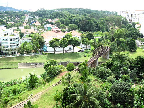
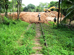
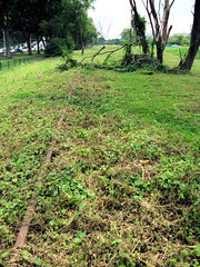
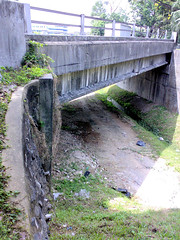
The photo turned out to be this:

Courtesy of HWZ member
tecnica in this
thread. Like Chun See, I also have not seen the bridge before. The desire to explore the bridge prompted me to continue my trail along the lost railway line.
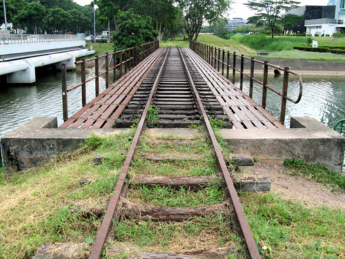
Look at the bridge again. From the photo, it is hard to tell that this is a railway bridge, unless you recognize the sleepers at the edge and its striking resemblance to the Sunset Way bridge.
Like what
Kuriyu Kouhei tells us, what's invisible is more than what's visible. The whole bridge, the railway tracks beside it, how do they look like? Are the tracks still there? Where is this place even? They are invisible now.
It is time for another adventure.
****
Planning
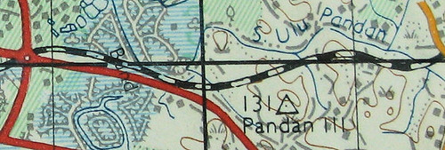
As I'm unfamiliar with the west, I asked my friend Johnny who lives in the west and who used to work at Jurong East to pinpoint me to this place which is near International Business Park. Johnny pointed me to a google map with the HI-P Building placemark and told me my target is south of it.
So the plan was to follow the track after the Sungei Ulu Pandan railway bridge and reach the target, which is like in the middle of nowhere along the Ayer Rajah Expressway. Therefore the trail was extended until the Teban Flyover, after which I will try to find my way towards Jurong East MRT station.
At this point, I got a nasty surprise.
This was the night before the trip. At this critical juncture, I realized I did not have with me any street directory map showing the Jurong Line. There was no scan of that stretch of the railway either on Chun See's blog. Opps!
A map with the railway line is indispensable, so I had to have one, even if it is my own creation.
So I took an old contour map from my collection and combined it with Peter's
description of the stretch:
After the railway crossed the Sungei Ulu Pandan, it swerved to the right (the tracks are still there in front of Clementi blocks 301 and 305) and ran parallel to the river until somewhere behind the Clementi Fire Station and the Buddhist Temple. Then it turned to the left, cut across Commonwealth Avenue West and ran behind ITE Clementi and Faber Terrace until it reached the AYE where it then followed the road westward to Jurong.
An aerial reconnaissance of the stretch also helped in my map creation. I could then doodle the railway line on a modern map.
Ready to go!
 Top: The old contour map.
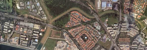
Bottom: Aerial view by Google Earth. AYE essentially unchanged from the old Ayer Rajah Road. The railway line is traced out by the forested stretch, neatly dividing the houses around Faber Terrace. Sungei Ulu Pandan seems to have modified its course.****
Mission
After a toast and cold coffee at Ya Kun, I hopped on the train to Clementi. There, I took a shortcut to the bridge, i.e. along Clementi Ave. 4, and was surprised to find the road terminating at the white-canopy pedestrian bridge. The railway bridge is not far away. There is also the much-talked about "garden" beside the railway track, where a mini kampong environment thrives under block 305 and 301.
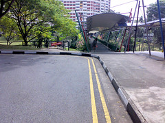
 Left: The pedestrian bridge.
Right: The garden, just before the railway bridge crosses the river.I was stuck. Once on the Ulu Pandan Park Connector, there's no easy way to access the railway track. I could probably attempt the slope in front of 305, but it looked steep and I didn't want to repeat the Sunset Way Residence scenario where the railway track was fenced up from the outside.
So how did I get down from the railway track last time? Remember, I crossed the (scary) railway bridge in my previous article and magically found my way onto the park connector where I took a
picture. Well, it wasn't by magic. It was a down-slope journey across the garden, trampling some greenery in the process.
Not wanting to invade somebody's garden again, I continued along the connector, hoping to find a "breakthrough" (pun intended).
The breakthrough finally came under the Clementi Ave. 6 Flyover. Plants don't thrive very well under a bridge, so it was an easy way up - on sand. No greenery was harmed in the process.
 SLA map from pedestrian bridge to Clementi Ave. 6 Flyover.
Once on track, I walked back to the starting point after the railway bridge. No cheating, a railway exploration is to be conducted along the railway. Every inch of ground is to be covered.
On the way back, I found out I was right. The railway land is fenced up from 301 and 305. Not only that, there is also a drain, like a moat, separating the land from the housing blocks. But quite unexpectedly, I found a gate. Woohoo, so there is a way to the outside world. I'm guessing this gate is for the convenience of the residents maintaining the garden. Seizing my chance, I left the railway land and took the lift up 305.
 The railway bridge from block 305. I vaguely remember Chun See has a similar photo taken from one of the blocks. Only after the trip did I realize it was the same block. Our photos are uncannily similar.
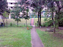
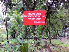 Left: The gate to the outside world.
Right: A sign beside the gate. Assuming the sign is not outdated, the railway land still belongs to Malaysia. The small print reads - By order Federal Land Commissioner for Government of Malaysia.Please don't prosecute me. I'm doing this all for ......... heritage. :-(
And to satisfy my curiosity about the lost railway line as well. So I walked back to the Clementi Ave. 6 flyover. There, the first sign of destruction greeted me. I saw the excavator at work.
I met one of the workers there, asked him what they are building. He couldn't give me the answer, only told me what I already knew, that the land belongs to Malaysia. So it is unclear which party initiated the destruction project.
It was unfortunate that the trip was carried out on a Saturday, a working day for the workers. On the previous trip, I could walk along the destruction stretch at Sunset Way. The reason: it was a Sunday. Since I don't dress and behave like Phua Chu Kang, I had no choice but to skirt around the area.
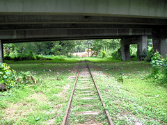
 Left: The railway runs under the Clementi Ave. 6 Flyover.
Right: After the flyover, first sign of destruction after the railway bridge at Ulu Pandan.The destruction stretch ended just before the Commonwealth Ave. West flyover, behind Clementi Fire Station and the Buddhist Temple. There, twin bridges, one for vehicles one for MRT, span across the water. From them, I noticed something interesting about how bridges in general are constructed. The bridge support near a waterway is invariably attached via a horizontal support to the bridge belly. This is done probably to maximize the surface area of contact, to better spread out the force. I've always been crappy at Physics, but thanks to the Almighty, I got A for my A levels. That marked the end of my physics education; I've not touched it ever since. So forgive me if the theory sounds crap to you.
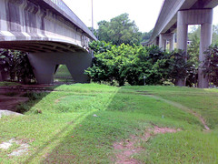
 Left: The vehicle bridge and the MRT bridge. The railway track can be seen clearly under the vehicle bridge. Note the peculiar design of their bridge support near the waterway (the design of the S.Ulu Pandan railway bridge is similar too).
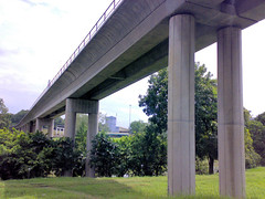
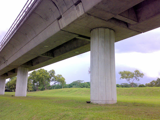
Right: Why different design for the MRT supports? Normally MRT supports look like this.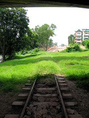
 Left: Under the Commonwealth Ave. West Flyover, towards the Buddhist Temple.
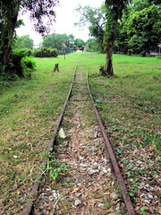
Right: Under the same flyover, but towards ITE Clementi.After the flyover, behind ITE Clementi, the vegetation thickens. The track was almost invisible, if not for the trackbed.

 Left: The trackbed can still be seen despite the tall vegetation.
Right: Close-up of the trackbed. SLA map from Clementi Ave. 6 Flyover (on extreme right) to ITE Clementi.
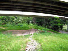
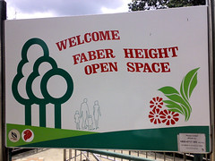
After the verdant patch, a bridge greeted me. This is the bridge at Faber Heights. A colorful but quiet playground - Faber Height Open Space - sits beside the bridge. The bridge is the only way to access the private housing on the other side of the track (refer to the google map at the beginning). The bridge design reminds me of the flyover for planes across the ECP. The belly is very wide, with no breaks in-between.
With such a wide belly, it is no wonder plants don't thrive very well underneath and as a result, the track and sleepers are almost perfectly preserved.
 The Faber Heights vehicular bridge.
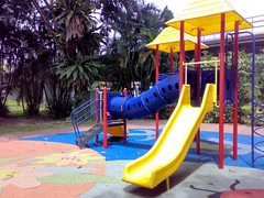
 Left: Colorful playground at Faber Height Open Space. The vehicular bridge is behind.
Right: The sign at the top of the bridge.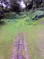
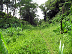 Left: View from bridge, towards ITE Clementi. The thick vegetation disappears just before the bridge.
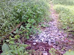
Right: A closer view of the thick (and tall) vegetation.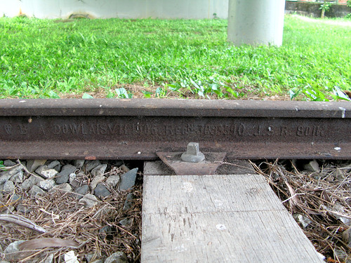 Track and sleeper almost perfectly preserved. Can you read the words on the track?
After the bridge, the trail can be best described as a walk behind others' backyard. The railway track passes in between two rows of private housing. I was barked at by a dog - thankfully inside the premise - while trying to shoot the track. I'm not sure why the hostility, after all I wasn't trying to shoot the dog.
If you are observant enough, you'd remember a tree is blocking the track just after the bridge. Behind this tree, vegetation covers the track for a stretch, making the track stick out like a sore thumb. You should be able to see this on Google Earth. I think the vegetation grew after the track was disused or they would be a safety hazard to a passing train. It is also possible due to Malaysia's ownership of the railway land, local authorities were not authorized, or did not bother, to trim the vegetation.
 Left: Wooden pieces lying beside the track, not sure what they are for.
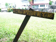
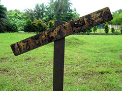
Right: Railway sign, probably a gradient post.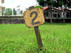
 Left: Mysterious railway sign, a stopping marker?
Right: Even if it is a stopping marker, why did trains have to stop here?After the mysterious sign, the track bends right, almost merging with AYE bending left. At this point, the row of housing ends and the track follows the road westward in parallel.
There, I saw another sign that threw me into confusion. It looked like another gradient post but the numbers were different. Gradient posts are described in this
website:
Gradient posts are placed, facing the track, at each location where the gradient of the trackbed changes. Gradients are expressed as a ratio, e.g. "1 in 200" means that the track rises (or drops) one unit in every 200 units travelled horizontally. The angles of the gradient post's arms indicate the direction of the slope. Some designs of gradient post omit the "1 in".
So for a train travelling westward, the first post will be 140-140 and the second one 333-130. My picture of the 140-140 post is misleading; the arms look straight but that is only because the whole post is slanted; by straightening the post the arms will be slanted. If my understanding is correct, it is like a constant deceleration in height followed by a decreasing deceleration. I'm picturing the slope like a velocity-time graph. As mentioned, my physics is crap so you better double check mentally.
The posts are confusing because I didn't feel there was a slope along the way. So are they gradient posts or not?
I hope a railway enthusiast can help. If possible, also verify whether the first mysterious sign is a stopping marker and why the train has to stop at that location.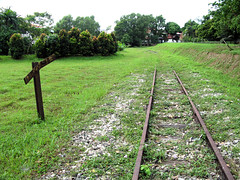
 Left: The track, looking eastward, turning in from the left. AYE is on the right.
Right: The second gradient post?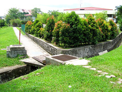
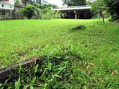
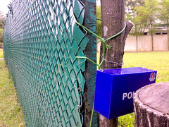 Left: End of private housing. This triangular plot of land is empty now, but because of the fence, I believe a building used to occupy the location.
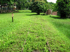
Right: Close up of the fence and what seems like a police postbox. Not sure of the function. As I approached for a shot, the box suddenly moved. I jumped. I think some funny creature was residing inside, maybe a lizard?!The track, still visible, follows the AYE for a short distance before the objective. On the right side is some kind of secondary jungle, probably like what Peter saw in his
article on Bedok. Interestingly, from the contour map, that area (which starts opposite the triangular plot of land) used to be part of a water surface. I'm guessing from the color on the map and the fact "Bund" is labelled. However, I'm not sure what kind of water surface is that. Doesn't look like a lake or river or mangrove to me.
 Left: The track, looking eastward. The deformed track reminds me of my physics "expansion and contraction" lessons where a similar picture is shown in the textbook.
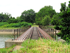
Right: The same deformed track, looking westward. AYE is on the left.Finally I reached the objective!
Nothing could contain my excitement. Since the day I saw it in hardwarezone forum, I had been planning to pay the bridge a visit. Good thing the hardwarezone picture shows only part of the bridge; this only compounded my curiosity and built up excitement along the way.
The excitment turned into fear at the objective, however. I was still afraid to cross a railway bridge after crossing two such bridges during my previous trail. I probably watched too many Indiana Jones kind of movie - a bridge suddenly collapses while you are crossing, and you are forced to run as fast as you can before you realize you are threading air. The last part happens often in those Looney Tunes cartoon.
Oh yes, there's also the low metallic reverberation. It was there.
 The bridge over the River Pandan It bears a striking resemblance to the one at Sunset Way, except this still has track and sleepers on it and is longer.
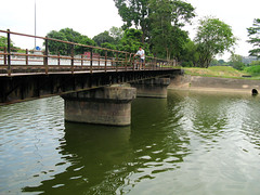
 Left: A man crossed the bridge before me, pushing a bicycle along. This did not increase my confidence. Say, if the bridge collapses the Looney Tune way, he can still hop on the bike and escape faster than I run.
Right: I have crossed the bridge!Hmm, now that I think back on those bridge crossings, a feeling of eeriness starts to envelop me. I mean, have you realized, on each occasion, without fail, there will always be people on the bridge?! Coincidence?
Or maybe this is the Almighty's way of telling me, "look, you can also be like them."
I was never alone.
****
Exfiltration
Ok, technically I had completed the mission - River Pandan railway bridge had been found. But I was in the middle of nowhere along AYE and had to be exfiltrated.
Put this in perspective. Unless you can say "this is my father's road" or "this is my grandfather's road", you have to be exfiltrated because the road does not belong to you. The only difference lies in the method of exfiltration.
For Victor Koo and Chun See who conduct similar missions deep behind enemy lines, they too require exfiltration. In their own words:
Victor:
The last photo was taken last Sunday at about noon time. Traffic was light at that time even in the city centre as it was not a working day for most people. You can tell from the photo that I was in the full-day bus lane. I was in my car, stopped by the roadside for about half a minute, with hazard lights switched on, of course. Took 3 photos with the driver's side window wound down and chose this one for the blog.
Chun See:
By the way, I have also started to explore stretches of the old rail way line along AYE and Teban Gardens - only those places easily accessible by car I must add.
Notice the similarity? They were quick to assert their mobile fighting capabilities. So they are like cavalry on horsepower while I'm infantry totally dependent on leg power, or bus 11. Victor even described his shooting - no I mean sniping - experience from the vehicle.
(I'm not sure whether Peter drives, but his ability to go anywhere in Singapore reminds me of a unit more elite than the cavalry. Does Navy SEALs sound familiar to you? SEAL is acronym for sea, air and land.)
Time to move on. Stop laughing.
 SLA map from Faber Heights Bridge (on extreme right) to south of HI-P Building.
After the bridge, the exfiltration route took the form of a flat, but at times deep, grass patch. The landscape does not look like railway land. Neither was the track visible all the time. This continued for a while until the flatland changed into a valley. The end of the valley is not visible because the track veers to the left (refer to the contour map at the beginning).
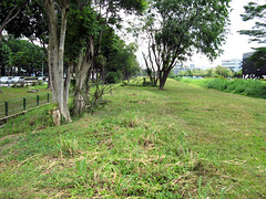
 Left: This flatland does not look like railway land.
Right: The track is sometimes visible, betraying the land's identity.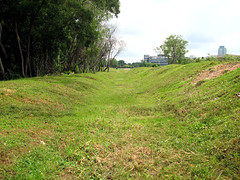
 Left: The start of the valley landscape. The valley veers to the left at the end.
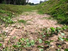
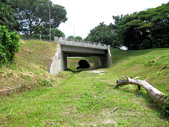
Right: The track is sometimes visible, this time under soft sand.After the left turn, the Teban tunnel appeared, a black hole at the end of the grass patch, a bit scary if you are not expecting it. Unfortunately a portion of the soil gave way (eroded?) to expose a gutter and the track. I leaped.
Then the last obstacle presented itself - a steep climb up a slope to reach the road level. There's nothing to grab at the side if you slip, so be careful. Even for an experienced foot soldier like me, the slope was a bit of a challenge.
When I climbed the slope, my energy was drained. I only had a toast and coffee for breakfast and that was many hours ago. I had been walking almost non-stop - stopping only to shoot - without resting on even a bench. Best, I did not bring any food or water with me (it was deliberate). So I had not drunk anything since that half-filled cold coffee in the morning (Ya Kun threw in lots of ice to chill the drink). I can do that because I'm an experienced foot soldier and know my body condition. Please do not follow my example.
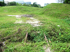
 Left: The drain obstacle at the end of the valley turn. The track is visible.
Right: The black hole under Teban Flyover.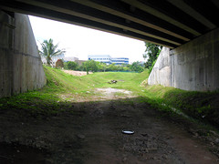
 Left: Under one of the flyovers, looking towards the valley.
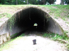
Right: The Teban tunnel close-up.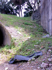
 Left: The final obstacle, a steep climb up to the road level.
Right: At road level, looking down the slope.The map I brought was cut off at the flyover region, so I had to find my way to the MRT station. The march along Jurong Town Hall Road seemed to take forever. Jurong East Station finally appeared at the corner of a big, empty field on the right.
But the station was like a mirage masquerading as oasis, luring weary travellers and making them even more weary. The station was also like a mountain, perpetually stuck outside a moving train and then disappeared after a long nap, your target gone.
The mountain eventually disappeared behind some buildings. A road appeared on the right and I turned.
 Left: I have reached the "summit"!
Right: An oasis is waiting for me!What happened next was purely survival instinct...
Wait a minute, you don't think I jumped into the water, do you?
I mean what happened next was I saw Jurong Entertainment Center, a familiar landmark, so I walked towards it. Duh!
I wanted to settle my lunch inside, as I had not eaten or drank since morning. But it was infuriating, to say the least. The place was crowded on that Saturday, the culprits mostly youngsters, and I wandered among the few fast-food outlets on ground level. I must have walked past each outlet many times. I almost wanted to call it quits and left for home on an empty stomach.
Eventually I gave in and simply walked into McDonald's.
I was lucky to find a seat. I ordered À la carte because I was not hungry as much as I was thirsty. Fried, oily food did not appeal to me in that condition.
The food came.
But I did not devour them like a lion.
Instead, I whipped out my handphone and proudly recorded down the historic moment.
Exercise cut!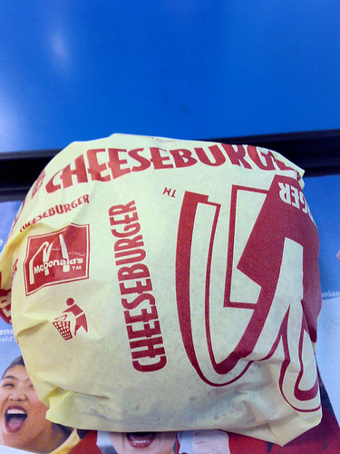 The cheeseburger looks so photogenic in my camera.
 Now, this is the real oasis!PS: Coincidentally, both my breakfast and lunch costed $3.80. The medium coke was more satisfying than the half-filled-cold-coffee-in-small-cup. From the receipts, breakfast was eaten around 0923 and lunch around 1420. From the SMRT record, I exited Clementi Station at 1036. Effectively I went without food and drink for 5 hours and walked for 4 hours.Bonus: The actual maps used in the mission. I carried a messenger bag, so while shooting with the camera, the map would be tucked between my chest and the strap. As you can imagine, the map was soaked with sweat and almost torn from the repeated movement. It was dry in the picture because I did not use it after the Teban tunnel.


