Pages

Jun 23, 2008

Surprising Find at Kent Ridge Park

I had a couple of 2nd shot targets in the South Buona Vista area and in my bid to find two of them (I failed), I stumbled upon a surprising find at Kent Ridge Park.

From the Nparks website, Kent Ridge Park is famous for the canopy walk linking it to the museum Reflections at Bukit Chandu and decommissioned military vehicles on display - M114 artillery guns and a AMX-13 Light Tank. I have known them from previous visits to the park, but this visit yielded an important discovery.

In fact, the website does hint of it vaguely, but it is easy to be overlooked among other more popular activities. The website also does it injustice by not highlighting it in its official map online. The signboard maps in the park do, however.

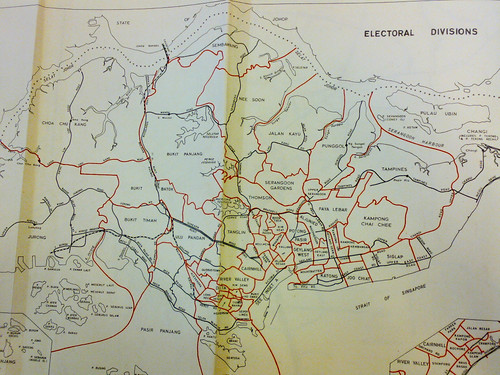
This is the official map:

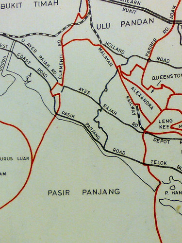
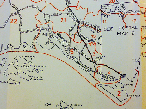
This is a map from another website, showing what's missing in the official version. Can you spot the difference?


Lying on the slope of Kent Ridge Park, away from the well-trodden paths of the Park, lies Kent Ridge Park's very own Mountain Bike Trail! This is surprising because I'd never imagine Kent Ridge Park to have one like Bukit Timah, Ubin or Sentosa where their land contour is a natural candidate for a mountain bike trail.

I thought the hilly slopes of Kent Ridge Park is but natural vegetation and there is no way up the Park from South Buona Vista Road other than Vigilante Drive. It therefore came as a surprise when I found myself at the bottom of the slope, beside South Buona Vista Road, by following the trail on the top of the hill.

According to SACA's website, this could easily be the toughest off-road mountain bike trail in Singapore. There is a cross-sectional view of the trail from their event poster:


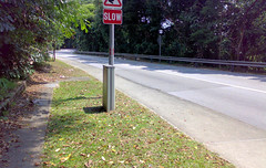
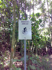
You can feel your adrenaline pumping seeing the "Steep Downhill Ahead" sign:

Kent Ridge Park Mountain Bike TrailKent Ridge Park Mountain Bike Trail

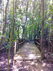
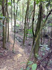
There is nice scenery along the trail, for example this bridge:

Kent Ridge Park Mountain Bike TrailKent Ridge Park Mountain Bike Trail

If you feel the "Steep Downhill" is bad enough, wait till you reach this "Dropoff Ahead":

Kent Ridge Park Mountain Bike Trail

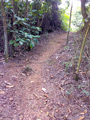
To be honest, the trail got me excited because it is deja vu once again. I've lost track of my frequent walking miles from those years, up the hill, down the slope, day or night we be there. I have walked on countless similar terrain like this, but the ground was surprisingly dry that day. It would be muddy and slippery last time.

Kent Ridge Park Mountain Bike Trail

I think the biking trail is out of bounds to hikers for safety reason, but alternatives are available in our green country. Which is why the trail is attractive to me - it is easy to get lost in Bukit Timah or MacRitchie forest trails but this one is pretty short and part of it borders the road. In comparison, the MacRitchie trails can easily take a few hours.

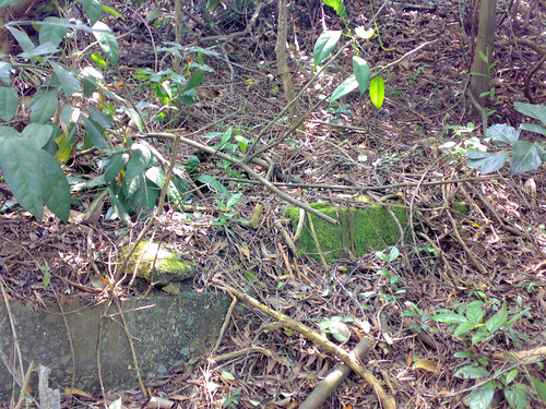
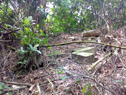
Along the trail, I found man-made remnants on the top of the slope. I'm not aware of any buildings or structures on the slope. Does anybody have any clue?

I'm surprised to find such a nice trail on the slope of Kent Ridge Park. Finding the remnants is a bonus, for they might be clue to a building that once stood on the top of the hill.


Kent Ridge Park Mountain Bike Trail

Kent Ridge Park Mountain Bike Trail

Jun 21, 2008

2nd Shot: Buona Vista Road

Buona Vista was so named because of the good view it offers — buona vista means "good sight" in Italian. Indeed Buona Vista offered good view of the Pasir Panjang Ridge and the sea beyond during the early days, as shown in the source of my second shots.


South Buona Vista Road

Source 1
Source: National Archives of Singapore PICAS
Caption: Pineapple Plantation at Buona Vista Road
Record Date: 1900
2nd Shot
Date: May 2008


South Buona Vista Road

Source 2
Source: National Archives of Singapore PICAS
Caption: View of Buona Vista Road, Singapore
Record Date: 1910
2nd Shot
Date: May 2008

The photos, taken at different times, were shot at neighboring locations. In source 1, there is a tree where the road bends around the hill. In source 2, there is a big tree in the foreground. They are uncannily similar. If a photographer stood at the bend in source 1, he should produce a shot like source 2.

So where are these two places today?

The photos should be taken at the Gap area of Buona Vista Road because of the proximity to the sea. After looking through map photos of the Gap, here is the most likely candidate along South Buona Vista Road. Indeed the valley below the pineapple plantation looks like where part of the future Prince George Park Residence will be built.

With clue and camera-phone in hand, I took the 2nd shots under the punishing heat of the midday sun.

Unfortunately, for source 1, the high ground where the picture was taken is gone. There is no way to reproduce the 2nd shot accurately. I have to be contented finding the next best "high ground":

South Buona Vista Road

High indeed. Luckily I did not fall down for my effort, after risking my limbs and all. The motorists would think I'm crazy though, standing on the, er what's that called, box.

This explains why the angle at which the road appears from the corner of the first 2nd shot is off. If I were to stand at the position in the above photo, the 2nd shot will be more accurate.

Next, I tried searching for our friend the tree. It has been 100 years since the photos were taken. We can see striking changes, like over the years, part of the cliff in source 2 have been chipped away, so the bend is more gentle now.

Sadly, I couldn't find the tree. None of the trees resemble it. I think it is gone. But imagine if the tree survives, how would it look like?

By the way, anybody knows what tree is that?

Terrain Features

Given a map, can you identify the terrain features? If your geography lessons are but a distant memory like mine, then it is time for a refresher course.

On identifying terrain features, the US Army require their soldiers to identify five major and three minor ones on a map:

Major Terrain Features
  1. Hill
  2. Ridge
  3. Valley
  4. Saddle
  5. Depression
Minor Terrain Features
  1. Draw
  2. Spur
  3. Cliff
What's interesting is, according to the ArmyStudyGuide website, terrain features can be learned using the fist or hand, to show what each would look like on the ground.

This, I wasn't taught in my geography classes.

The study guide contains short instructions with useful illustrations on identifying the terrain. Do check it out.

Why is Clementi Labelled Pasir Panjang?

Lam Chun See posted a question in his blog about why in the 1981 and 1963 street directories, the area south of Ulu Pandan Road and Sungei Ulu Pandan was known as Pasir Panjang. I might have found the answer.

In the July 1972 street directory, there is a very important map pullout in the appendix. Here is a picture using my camera phone:

ElectoralDivisions

The Pasir Panjang area, enlarged:

PasirPanjang

If we compare the photo by Chun See with the area demarcated by the electoral map, it is possible that Pasir Panjang on Chun See's map is a label for the electoral division.

A bit of history. Pasir Panjang used to be a Group Representation Constituency (GRC) by itself. In 1991, it merged with Brickworks GRC to become, erm, Brickworks GRC. In 1996, Brickworks GRC was scrapped. Today the area is under West Coast GRC.

There is another possibility though.

The same street directory reveals another interesting map:

PostalDistricts

It is a map of the postal districts then. Notice how the area labelled 'Pasir Panjang' on Chun See's map is in district 5.

Interestingly, postal districts are demarcated in certain areas by the Sungei. For example, Sungei Ulu Pandan draws the boundary between 5, 10 and 21.

In the same street directory, two postal districts (5 and 21) divide up Clementi Road. However I notice something strange. From how the milestone is recorded, Clementi Road should start from the southern, Pasir Panjang, side, but where is the stretch before the 7 milestone??

RoadPostalDistricts
By 1981, Postal Districts had made way for Postal Codes:

RoadPostalDistricts2

Once again, Clementi Road is divided into two. However this time, the boundary is pushed further up. Back in 1972, the boundary was at the 9 1/2 milestone which, according to the postal district map above, is just before the Clementi Road and Ulu Pandan Road junction. The milestone is not marked on the street map, so I'm making an educated guess based on the island map above.

By 1981, the boundary is at Lorong Gaung. This has disappeared, but its location is just opposite the present Corona Florist nursery. I will blog about this next time, but meanwhile do read Peter Chan's fascinating entry on it.

Back to our title question. Both my hypotheses have their weaknesses. On the electoral map, the area to the left of Clementi Road (future Clementi New Town) falls under Bukit Timah. The Pasir Panjang label, however, cuts into the area left of Clementi Road. On the postal district map, no such problem, however this time the label cuts across Sungei Ulu Pandan.

To summarize, the electoral map uses major roads to demarcate boundaries. The postal district map uses rivers. The Pasir Panjang label, unfortunately, cuts across the road and the river.