Pages

Sep 30, 2008

The Historian as Storyteller

After reading this article by Justine Ferrari, we can better appreciate what the oldies are doing in recounting the past. I can't agree more with historian Peter Cochrane.

I have always enjoyed history as a narrative. In my school days, I invested my time and energy in the history of China, not as an academic subject, but something I pursued in my spare time. I felt a sense of accomplishment when I corrected my teacher publicly in class about her slip in recounting a Chinese historical narrative. She was from the PRC while I'm from Singapore.

I built up a small collection of materials related to my interest. In those days when Internet was in its infancy, I visited the libraries to build up my collection. If time permits, I may consider deviating from the usual stuff and blog about my interest in Chinese history. But I have yet to explore many places in Singapore and unravel their mysteries, so I'm not sure when that will happen.

Here, I present my snippet summary of the article.

**********

Historians Neglecting Storyteller Role


HISTORY has been "dulled down" by focusing exclusively on analysing evidence and argument, with historians neglecting their role as storytellers.

Award-winning historian Peter Cochrane is urging his colleagues to look to the narrative techniques of literature to recreate the past in a vivid and lively way.

Cochrane, an inaugural winner of the Prime Minister's Prize for Australian History, said historians should be able to cross freely into the territory of novelists and poets to use their techniques of plot, character, and imagination.

"We spend a great deal of our time on the intricacies of analysis, evidence evaluation and argument while we tend to neglect the literary side of history writing," he says in a speech prepared for this week's Australian History Teachers Association annual conference in Brisbane.

"This, I think, is an old, ingrained prejudice. Historians tend to see themselves as social scientists, as scholars whose job it is to 'write up' or report on their findings, rather than as writers whose job it is to create or imagine the past, to captivate an audience.

"We should be crossing boundaries and borrowing what we can from fiction, or at least from fiction writers ... in terms of structuring and vivifying a story."

.
.

While historians could not empathise like fiction writers, Cochrane said they could infer or extrapolate from records in an imaginative approach that brought the characters and story to life. Without a historical imagination, Cochrane said, history was not much more than a retranscribing of records.

"History has to be vivid, creative, imaginative; it has to squeeze every ounce of historical juice out of the record and then leave it to the reader and other historians to say if you went too far," he said.

.
.

Narrative skills were needed to bring history alive: devising a plot, composing a paragraph, choosing a metaphor and evoking the character of the protagonist are all fundamental to the skills of history, all require historical imagination. "The history profession, with some exceptions, has been wary of biographical or character-driven narrative mode because it might be the 'first step into the Hades of commercialisation and dumbing down," he says.

"Narrative movement, along with character and human drama, is essential to the historian's duty to ensure the story's not a bore.

.
.

Sep 22, 2008

My First Train Spotting Experience

(My first train spotting on 200908. I hope the readers don't find it too mushy.)


Initial Encounter

There is no mistake. I'm going back.

You see, last Saturday while executing my missions, I saw a most magnificent train to travel past Ten Miles Junction.

The time was 5:03pm.

Moments before, I was still wondering whether a train would appear. They don't appear every few minutes like the MRT or LRT and I consider myself lucky if one is spotted.

Then .... (substitute the sound of train approaching). Before I knew it, she was moving horizontally across my eyes.

I was too stunned to take out my camera.

**********

Missing Her

From that day, I began to ask around frantically. A bit exaggerated, but I did attempt to find out more about the train. From email correspondence with railway enthusiasts, I learnt that it was a freight train. The train can be described as a flatbed wagon or flatcar, or what I call long trolley on wheels. But there was no freight on board. The locomotive was pulling a never-ending series of flatbeds with nothing on top. It was my first time seeing such a train. Normally the locomotive will be pulling passenger compartments or boxcars and if you are too used to seeing MRT trains on viaducts like me, you'd forget a train can be much much longer.

I have to find her again. Not even the cars and babes from Super Import Nights can deter me.

**********

The Mission

I took a gamble. Without consulting any railway enthusiast or website, I assumed the train would come again next Saturday at the same time. If not, I would return from Choa Chu Kang a dejected person. The mission would have failed and this blog would not be written.

My destination: Ten Miles Junction. The map shows the railway line crossing over the LRT line and under Choa Chu Kang Road. This is misleading. The LRT line is elevated and the railway track crosses the road as a level crossing.

**********

Where is the Bus?

At 4:40pm I was pressed for time. No proper planning was done before the trip and I reached Choa Chu Kang Bus Interchange with the impression there would be many buses to Ten Miles Junction. I couldn't be more wrong. There were only two and they would only come few minutes later.

I panicked. Should I hail a cab? Or take a bus from outside the interchange? Precious seconds ticked by. I knew I was doomed. Even if a bus were to come now, I might not reach there before the train.

**********

A Long Wait

The wait had become excruciating. Once again, precious seconds ticked by. The train still had not appeared.

At the interchange, a bus - service 67 - arrived at the berth, before time. I hopped onto it and hoped for the best of luck. I alighted at Phoenix LRT Station around 4:55pm. Phew.

I thought I would be late, but the train, if she were to come, snatched the honour. Three minutes past five. That was when she appeared at the same time one week before. I planned to give her 15 minutes grace. Then fifteen minutes past five. Was she going to come?

Waiting for her was not fun. I looked like a fool loitering above the canal. Instead of flowers, I had brought a camera.

The pavement had more than a few people walking. Plus there was a female security guard or car park attendant sitting nearby. I felt like a terrorist in her eyes, so I ensured the LRT viaduct pillar stood between us. However I could do nothing for the people streaming past me. What did they think I was doing, then?

To kill the boredom, I started imagining things. Looking at the crossing barriers pointing to the sky I thought, what if it goes down with a car just below? Will the windscreen get smashed or will the barrier get dented, in the event it is not a car but a truck?

Choa Chu Kang Level Crossing
Choa Chu Kang Level Crossing. For vehicles flouting traffic rules by stopping inside the yellow box, what if the barrier on the right goes down at this time?

I tried to kill time by doing other things - loitered around, stared at the dirty canal water, flipped my street directory (I think so), looked at my watch; every now and then stealing a glance at the barrier.

The barrier was the only clue to a train approaching. I dared not stand near the barrier, for fear that in my excitement of an approaching train, I would miss the barrier coming down on me. Neither was it a good idea to wait on the track - the pedestrians and vehicle drivers would find me idiotic or suicidal. Now I wonder what do real train spotters use to scan for approaching trains? A binoculars? A telescope?

Grace period over. No sight of the train. She stood me up. But wait, did she ever promise to come again next Saturday, at the same time?

I left the spot in disappointment. I still harbored the thought of seeing her, so I left the spot but not the place. I skirted around the mall to the heavy vehicle park on the other side, to check out the railway bridge (over the canal) from that position. I saw the bridge last Saturday - the ugliest railway bridge that I've seen in Singapore.

By this time, the mission was already a failure. Even if she were to arrive, I would not be prepared. With no clue from the barrier, the train would just move across unexpectedly like last Saturday. Worse, she might arrive just when I am in front of the mall.

**********

The Diversion

The bridge is ugly all right, regardless of your position from it.

At the heavy vehicle park, the stretch of railway was visible behind the canal. As expected, no sight of the train. I had gave up by then; I was there just to look at the bridge.

The ugly bridge did not make me stay for long, so I walked back to my original position, not to wait for her but to leave the place altogether. Along the way, I shot the row of shophouses opposite Ten Miles Junction. That activity did not take me more than a few seconds. In fact I took only two pictures, from the side of the mall.

At the bend where Woodland Road turns into Choa Chu Kang Road, I turned to my right.

A short distance away was the level crossing, with the familiar sight of barriers and vehicles stopping and moving off, taking their cue from the traffic lights at the junction of Woodlands/Choa Chu Kang Road.

The vehicles were not moving this time; neither did they stop inside the yellow box but parked neatly behind it, like waiting for something to happen.

The barrier was down.

**********

The Finale

My mind yelled the four letter word (commonly associated with the latrine).

In that split-second, the legs began to take flight, the New Balance pounding the ground to achieve even faster speed.

The arms did a quick draw, one arm tearing the flap off the messenger bag, the other fishing the weapon out of it. The fingers, not idle, but twirling the dial to video mode.

The legs braked at the location where I stood few minutes before. This time, I saw her approaching from the distance.

Still huffing and panting nonetheless, I pressed the shoot button.

Mission accomplished!

**********

The Video


Here is the video from my first train spotting mission. As you will see, the camera rocked quite violently during the first few seconds due to the race to reach the crossing before the train.

Also, to make the video more original, I challenge the reader to guess the number of flatcars towed by the locomotive. Then watch, as the video counts the flatcars one by one to arrive at the answer.

Enjoy!

Sep 18, 2008

2nd Shot: High Street and North Bridge Road Junction

High Street and North Bridge Road Junction

Source
Source: National Archives of Singapore
Caption: Electric Tramcars at High Street and North Bridge Road Junction
Record Date: circa 1908
2nd Shot
Date: August 2004


This is actually my second 'second shot'. The first is here. After four years lying in a digital forest, it is time to let her see the world.

My old second shots are especially memorable. Back then, with the old 3.1 Megapixel Amconics, I would retake and retake the second shot, on multiple days, until they look perfect to me. They are still not perfect, but the end result looks better than those taken by the new 10 Megapixel prosumer camera.

How did it feel like to sit in one of those trams, I wonder?

Update: Victor asked in the comments how I oriented myself at the junction. Unless you are an oldie and frequented High Street often in the past (Aurora, Metro, Polar Cafe, TMA, Ensign Bookstore anybody?), or you have elephant memory like Peter Chan from GMY, the best clue will be the bridge in the background. That is the old Elgin Bridge. The bridge in the modern photo is the new Elgin Bridge.

Old Elgin Bridge
Old Elgin Bridge
Source: National Archives of Singapore

Sep 14, 2008

Our Friend Google Earth

Chun See asked me in the blog comment regarding terrain feature on Google Earth. While the feature is no secret, there are certain settings which I discovered that will give us a nicer shot of the hills. I started playing with the terrain feature only recently, while trying to get a "second shot" of the hills in Kanchanaburi for my Thailand trip. You can read about the adventure in my ongoing blog series.

Ok, Google Earth is started. You have found the hill you wanted. You are oriented to some compass direction (the middle mouse button is for that). What's next?

Next is to turn off those irritating layers.

Just joking. Though I still do it everytime. Layers like Geographic Web will clutter up the map with Panoramio or Wikipedia placemarks so I usually turn them off from the Layers sidebar.

Want to make those boxes disappear? Turn off Geographic Web from the Layers sidebar.

The next step is to make your application fullscreen using shortcut key F11. You'd want to see as much of the hill as possible.

When the hill is found, select a location you will like to see the hill from.

Then zoom in on the location. Before you touch ground level, tilt your view (using the middle mouse button) from looking at the ground to look at the horizon or hill.

Bukit Gombak using terrain feature. Notice the screen has minimal cluttering, the result of turning off whatever can be turned off in the View menu.

There you have it!

But this is not the end. You can actually make the hill look bigger. This is called elevation exaggeration. You may need it to make the ridge more prominent, for example.

Bukit Gombak with elevation exaggeration. Differences, like the height at different parts of the ridge, are now more prominent.

As an exercise, you can start examining your favourite hill in Singapore. Or try Mount Everest.

Before I end, here are some tips to make your favourite hill nicer. In Tools-Options, you get to set the elevation exaggeration, as well as the terrain quality and anisotropic filtering.

Google Earth Options dialog box. You get to set the elevation exaggeration here.

Sep 11, 2008

Where is the Location of that Artillery Gun? A Second Shot Mission

Thanks to Chun See's kind recommendation, I'm now on this mystery as well.

For those who have not read Chun See's blog articles on the mystery, you can go here and here. There is also the forum where a discussion is held among old British soldiers ('lau pengs') on the same topic which you can read it here.

To summarise, there are actually two mysteries - the location of H Sub Section and the location in Roger-Hatchy's photo. Or is it? Can they be the same mystery after all, with Roger-Hatchy's photo showing the location of H-Sub?

Like Chun See, the mysteries are also driving me (chest)nuts. I have been thinking of them over the weekend, poured over maps and executed a "second shot" mission to recce possible sites.

The process is nothing short of exciting. Here I thank Chun See for giving me the idea for the mission and I definitely agree with Peter when he said, "Wah this is so exciting trying to find old places."

Two things can be confirmed about the mysteries. Both locations were in the Tengah area and both gun deployments happened in the 1960s. If you were not around in the 1960s like me, you may be disadvantaged when trying to solve such mysteries. So without further ado, let me bring you back in time, to the Tengah area of the 1960s ....

Tengah Area, circa 1966

Before we look at the 1960s version, let's see how the area looks like today. A quick (and small) one.

Google Map Tengah
Courtesy of Google Earth. Highlighted lines are major roads. Start at Tengah Flyover where PIE joins KJE (near the left edge). If you are a driver or a resident in the area, the rest should be easy. Clockwise from Tengah Flyover, Tengah Airbase, the residental estates of Choa Chu Kang, Teck Whye, Bukit Batok, Jurong East and Jurong West (separated from its East sibling by a vertical canal).

In the 1960s, the residential estates had not existed. Neither were there PIE nor KJE. Instead life was concentrated in the kampongs located along the milestones of Choa Chu Kang Road and Jurong Road.

CCK Street Directory
From Street Directory, circa 1966. Choa Chu Kang Road at the top, Jurong Road at the bottom. Note the kampongs alongside.

So we have the old and new map of the area. In 40 years much have changed. For example, Hong Kah Village is gone and the name today is mostly synonymous with the electoral boundary. Thus with respect to the boundary set by the government, the maps do not actually show Tengah but Hong Kah. But because the old British soldiers take Tengah as a reference (the runway of Tengah Airbase was a prominent landmark from high ground), and that happens to be the locality name they remember most vividly, I will call the area Tengah.

As part of my second shot hobby, I like to find traces of old roads and imagine how they looked like before they got realigned or expunged. Unlike the oldies, I have no recollection of the old roads so I can only imagine. Luckily digital tools can help us bridge the gap.

Hong Kah Overlay
Overlay of a 1966 topographical map on Google Earth.

Looking at the overlay, I can finally trace out Choa Chu Kang Road or what was once it. From Tengah Airbase, the current Old Choa Chu Kang Road is the old one. At Track 14, it cuts across the KJE diagonally, parallels Jalan Lam Sam and the canal bridge, cuts the flats around Blk 462 and the field beside Avenue 5. Then at Old Keat Hong Camp I, I think it goes into the camp compound. In any case, it links up with Avenue 1 after the MRT underpass outside Camp II, cuts the field opposite Keat Hong LRT Station and finally links up with Choa Chu Kang Road at Teck Whye LRT Station.


Exact Location of the Roger Hatchy Photo

Do you know where is this place? Note that the photo is over 40 years old.


The photo posted by Roger Hatchy in the forum. This and more photos in his Photobucket.

Having lived in the Chestnut Drive area for 25 years as a child, Peter was quick to point out the 'mountain range' as Bukit Gombak. In particular, he recognized RAF Gombak radar station on the ridge. According to him, this is the view of Bukit Gombak from the Choa Chu Kang side.

Bukit Gombak
Top: Google Earth Terrain showing Bukit Gombak.
Bottom: The mysterious mountain of the 1960s from the Roger Hatchy photo.


Dear readers, what do you think?

To verify my hypothesis and to get a feel of the land, I executed a second shot mission. The plan was to walk along Track 22/Jalan Chichau/Jalan Lam San and survey the terrain, noting any possible targets. This seems to be the only road that cuts through the jungle mass between PIE and KJE. Then I would cross KJE to reach Jalan Lekar and check out Chun See's hypothesis as well.

Not sure why, but I sensed some of the passengers looking at me weirdly when I alighted from 174 at the Track 22 bus-stop.

In the Roger Hatchy photo, the camera seems to be facing Bukit Gombak perpendicularly and the saddle is at the center of the picture. Looking at the topographical map, there are two likely locations. The first is West Bukit Timah 117 and the second is Hill 140. I think I might have climbed up 117 located on the left side of the road. However the trees have grown quite tall and I couldn't even see Bukit Gombak, though I caught a glimpse of a tower (on Bukit Gombak) through the canopy. 140 is located at the end of the road that crosses the canal. It is unmistakable, the road cuts through a big field and there is even a road up the hill. Unfortunately, wild dogs guard the end of the road. I was scared so I turned back.

Hong Kah
Topographical map of 1966 showing West Bukit Timah 117 and 140. Standing on these hills, you will face Bukit Gombak perpendicularly and the saddle will be to your center.

Hill 140-2
Bukit Gombak from Hill 140. Looking at the topographical map, there should be a Hill 115 in front. I think it was flattened to develop Bukit Batok West.

Bukit Gombak from Hill 117
Bukit Gombak from Hill 117. Hill 140 is in front.

Location of H Sub

The only clue on the location of H Sub comes from the description of Ken Nichols in two places:

.... but when I saw the photo I immediately thought it was of my site which was located some distance to the right of the road which you would travel on when approaching Tengah from the Singapore city direction. To reach the site that I remember, you would need to follow a track leading off that main road which wound its way through a kampong and then you would negotiate a steep hill which was very difficult for the trucks to ascend until several truck loads of course gravel could be laid down. Once at the top of the hill the site had such a commanding view of RAF Tengah and the runway ....

.... it was situated some distance off the right hand side of the road that you would be travelling on if you were travelling to Tengah from the city of Singapore but I can't remember the name of that road. To access H Sub you would need to turn left off that road,.... probably about a km. before Tengah, and you would then follow the track as it wound its way through the Kampong area before eventually climbing the hill to the top where the gun was located. I remember the ascent to be quite difficult for the equipment towing Bedford trucks, and eventually it was necessary for a layer of course gravel to be deposited on the track surface to make the climb easier for the subsequent re-supply vehicles. From the top of the hill we could look down on the Kampongs on three sides but I vaguely remember being told that we should stay clear of the other side which was to the right of our position as we faced the runway at Tengah because that was the site of a cemetery, however that cemetery wasnt visible to us from the site so I never saw it ....

To summarise using Chun See's words:

it was off Choa Chu Kang, to the right, through a kampong, and up a steep hill with no proper road; and it had a commanding view of Tengah air base and the runway.

Thus Chun See's hypothesis:

My own guess is that the site our British friends referred to as H Sub was around the Jalan Lekar/Jalan Semangka area. According to my 1963 street directory, Jalan Lekar was just a small track of the main road which was probably a kampong then, and thus fitted Ken’s description.

Peter, however, did not share the same view. In the forum, he wrote:

Since you indicated the cemetery was on your right, then more accurately your position would have be today's "Hong Kah Road" or "Hong Kah Circle". Do the goggle search you find that the cemetery should be north of Hong Kah Flyover on the Pan-Island Expressway.

Therefore in Peter's view, they were travelling along Jurong Road rather than Choa Chu Kang road. I think this is a crucial difference that can break either hypothesis. So what was the favoured road to Tengah from the city of Singapore in the 1960s? Or did Ken take the less favoured road?

I went to the area mentioned in Chun See's hypothesis to check out the terrain. As it was near evening and I'm not cavalry, I did not manage to recce the whole Jalan Lekar/Jalan Semangka area but just Track 14. I knew about the cemetery from a friend living in Choa Chu Kang so I thought of going there to have a look.

Track 14Gombak from Track 14
Left: Cemetery at Track 14. Background shows Bukit Gombak.
Right: Close up view of Bukit Gombak from the same position.


The cemetery is on a small hill and I went to the top to take that shot. Bukit Gombak looks so small in the background, so Jalan Lekar/Jalan Semangka cannot be the location of Roger Hatchy's photo.

Conclusion

I believe I might have found the site of Roger Hatchy's photo. Of the two likely locations, I pick Hill 140. The hills around 117 are a bit far away from Bukit Gombak.; if you look at the topographical map, Track 14 lies roughly along the same vertical axis as 117, but in my cemetery photo, Bukit Gombak looks so small. I'm not sure if you were to stand on 117 with a clear view of Bukit Gombak, the latter will look much much bigger. Furthermore from 117, 220 lies in front, but in the Roger Hatchy photo, the hill in front does not look any higher than the gun hill. If it was 140, 220 would not be in the photo, instead 115 would be in front, which is around the same height as the gun hill. Unfortunately, I think 115 was flattened to make way for Bukit Batok West so there is no way to verify using Google Earth.

Comments?

Sep 6, 2008

Kanchanaburi: First Look

The current entry is part of a series of articles on my first overseas Second Shot project, undertaken in August 2008.
  1. Prelude: A Dream Up North
  2. Photo Essay: H-Hour 0630
  3. Kanchanaburi: First Look


So I have overran my objective at Suvarnabhumi.

That wasn't too hard. Tiger came to a stop. I sashayed across the jetway and got my red book chopped. That was it.

The Kingdom of Siam lies in front of us.

********************

And so is uncertainty and the fear of travelling in a foreign country with people speaking a different tongue. Luckily we planned for our missions before the trip and now standing on foreign soil, we have some ideas what to expect and a rough schedule to follow. (Eisenhower said plans are useless but planning is indispensable, so our plans are not set in stone.)

By now you should have guessed, we are going to Kanchanaburi. This will be our home for the next three days. So Victor got it right in the blog comments. =)

Before I reveal the success or failure of my second shot attempts, let me present an intelligence briefing on Kan (as we fondly refer to Kanchanaburi). If you are planning to go Kan, I hope this article is of some use to you. Ultimately this is but a debrief exercise for me. I hope to organize my knowledge in a coherent form and by recording it down, I can see how much I have learnt about the place after the trip. A written record will be useful for future missions too. The information presented is accurate to the best of my ability but I accept responsibility for any error. Feel free to comment/correct.

********************

Kanchanaburi is the name of the third largest province in Thailand after Nakhon Ratchasima and Chiang Mai. Coincidentally its land area is almost identical to Johor's - 19,480 km² v.s. the latter's 18,986 km² (Singapore is just under 700 km²). But unlike Johor whose capital city is Johor Bahru or JB, the capital of Kanchanaburi Province is also known by the same name. Kanchanaburi Town will be the focus of this article.

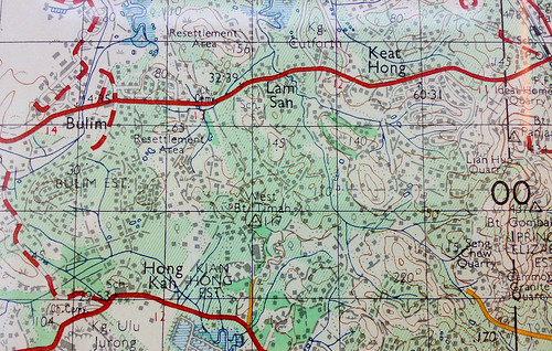
Size Does Matter (and what it means to be within a foot walk)

One intel failure, agreed by my travel partner also, is that we have underestimated the size of Kanchanaburi (Town). It is easy to understand why. On the net it is hard to find a good map of the town with distance indicated. When we finally found it, we were 'misled'.

The map we found came from the website of our guesthouse accommodation. Study it closely and read the accompanying description from the website.

The website description - Because of the central position, our guests can reach the famous Bridge over the River Kwai, the war cemetery, the Thai-Burma Railway Centre (TBRC) and several other local attractions within a foot walk.

No sweat! The attractions are all within a foot walk. On the map, it looks like you can even leopard crawl to and back with ease. Ok, I'm joking.

But no exaggeration here. On the map, the roads are straight, the surrounding barren and the labelled landmarks are within walking distance. A walk to the attractions feels like a stroll in the park. That was what I thought, really.

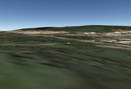
Now, let me show you what all the guidebooks and websites in the world won't show you - a "down to earth" comparison with Singapore.

Courtesy of Google Earth. Top is Kanchanaburi Town and the bottom Singapore City. Both are at eye altitude 2.24km. A stroll from the War Cemetery to the Railway Bridge is equivalent to a walk from Bugis Junction to URA Centre. In case you are not familiar with Singapore, the distance spans three MRT (subway) stations.

Now, the distance looks more daunting. It does not feel like a stroll in the park anymore. The journey from Bugis to Maxwell Road along North/South Bridge Road (大马路), on pavement, takes you under trees and buildings. In Kan, no pavement exists in most places and there is paucity of shade or shelter. Under the punishing weather, you feel like a participant in a death march.

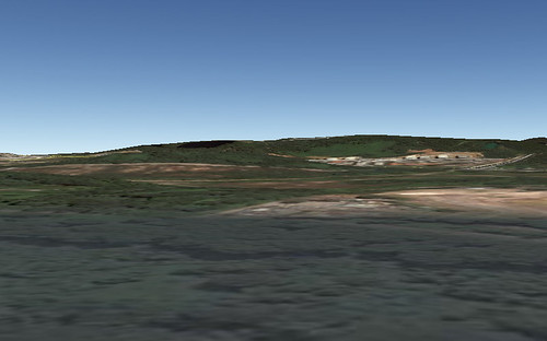
To be fair, let's examine maps from other advertising sources which I got in Kan.

Top is from a small advertising booklet on Tasty's Cooking School. Bottom is from a booklet on Pong Phen Guesthouse & Bungalows. Both use the same map template. The distance from the War Cemetery to the Railway Bridge still looks pretty manageable here.

Let's do a small exercise to exacerbate the confusion. Look for the train station on the two maps I scanned from Kan. Pretty much the only similarity is that it lies below the railway. They don't agree on how far it lies from the end of the railway bend. The first map shows the station as just below the end of the bend, the second one a bit further. Now look for the War Cemetery to its bottom right. Once again, the maps differ; the cemetery is much further away on the first one.

Which one is correct? Neither one of course. If you have been to Kan and your memory is still fresh like mine, you'd be amused at the exercise. The maps are quite divorced from reality. On the Google Earth aerial further up, I have marked the location of the War Cemetery. The ramrod straight road just above the cemetery is Sang Chuto Road. Further up is the railway. Notice the railway bend is so much further away than on the two maps. And the quite funny thing is, you can't even find the part where Sang Chuto Road suddenly bends.

What does all these tell you? Not that they are deliberately deceiving us of course. For the record, I stayed in a wonderful guesthouse (photos in future article). In the first place the maps are not marked as to scale. Their purpose is to show the landmarks in relation to one another, for that they are pretty accurate. Just as we should not stereotype Japanese girls to look like anime girls, those maps are not meant to be studied like a street directory.

When the website states "attractions within a foot walk", nothing could be further than the truth. The truth is that as Singaporeans, we have a Garden City - pavement lined with lush greenery, well-paved roads and because of our unique architectural tradition, we have shophouses, under them runs five-foot ways doubling as walking path and providing shelter. I find none of them in Kan. A journey from the War Cemetery to the Bridge will find yourself walking on the road, under a merciless sun, darting around stationery vehicles and electric (telephone?) poles and trying to keep a safety distance from moving cars or bikes. Don't ask me how long that will take. The furthest we walked was from the Bridge back to our guesthouse. Let's just say I was thankful it was done at night.

Free and Easy to Kanchanaburi

This is almost an oxymoron. When things are free or flexible, they are not always easy. The "free" part comes at a price. Whether it is reading the latest Lonely Planet or surfing TripAdvisor, research is necessary if you don't want any nasty surprise. This research, I feel, is a price worth paying for. You learn a lot this way.

At 128km from Bangkok and linked by highway, Kan is readily accessible from the capital via car, bus or train.

A cab from the airport or city will be in excess of a thousand baht, exceeding our budget. One cab driver quoted us 2000 baht after we told him we were heading for Kan. We were in his cab heading for the bus terminal when we engaged in small talk and blurted out our destination. He told us he could drive us to Kan at that price. His reply was as confident as his driving. I became nervous. The small talk was not conducted in the most perfect conversant English but a smattering of keywords like 'Kanchanaburi'. What if he thought we wanted to change course and go Kan? I declined politely and he took the cue.

A train ride to Kan was considered because tickets are cheap (100 baht/pax) and experience novel. However the travelling time, around 5 hours, put us off. Furthermore there are reports about the train being late, not good news considering our tight schedule. In any case, much as I relished a railway journey, the risks are too great for the payoff. The option was scrapped but I still got my train ride and if you persevere to the end of this blog series, you will get to see my pictures and videos.

So we took the bus. Getting to the bus terminal was an adventure in itself. We did not travel straight to the bus terminal from the airport because Cheng Cheng had to settle his stuff at Asoke. To get to Asoke, we took the Airport Express bus. The last time I took an 'Airport Express' bus was in Hong Kong, but that one was a double-deck. I don't remember seeing any double-decker in Thailand.

Airport ExpressAirport Express
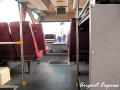
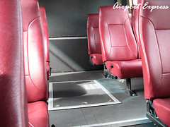
Left and Right: Interior of the Airport Express bus AE3 that took us to Asoke. Surprisingly the bus was empty except for us and one other passenger. There are four Airport Express routes (AE1 to AE4) serving the major hotels in the city. The cost is 150 baht. Of interest is AE2 ending at Khao San Road, the backpacker heaven in Bangkok.

AE3 Ticket
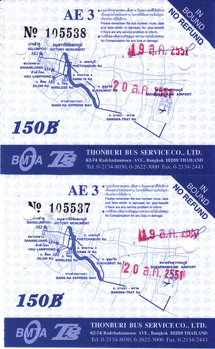
Our AE3 bus tickets. You can see the correction made on the chop for the previous day. Does this mean business was not good and tickets were over-indented?

At the shop in Asoke we discovered, to our amazement, that the shop assistants did not understand our destination. Make no mistake, they understood and spoke English comfortably but were puzzled at the mention of "Southern Bus Terminal". Eventually Cheng Cheng managed to get our destination across and they were kind enough to write us a note in Thai. The bus terminal's name in Thai is "Sai Tai Mai".

We are now in the cab earlier in the story. Other than the 2000 baht episode, the journey was memorable for his "zhng" ride and skillful driving. The engine, with its low purring, reminded me of a souped-up vehicle and its performance somehow confirmed my suspicion. The journey itself was quite long and took us under many long and beautiful bridges. The total metered cost was around 200 baht. Sai Tai Mai is quite far from Bangkok's center of action. It lies outside the Bangkok Metropolis Map. Check out cell A1, the upper left corner of the map - the terminal lies outside this region.

Courtesy of Flickr member sakichin - photo of Sai Tai Mai. We were searching for the Kan ticket counter frantically, so no mood to shoot pictures. The building was really new, I read that the bus terminal shifted quite recently but confusingly both old and new terminals are called Sai Tai Mai, if I remember correctly. I believe we went to the new terminal.

Bus 81 Ticket
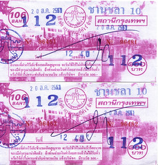
Our Bus 81 tickets to Kan. Departure time 1240. I think the official price is 106 baht but we paid 112 baht. This may be the much-touted 'farang price'. Or the extra baht may be for the free drink on the bus. (Note the Thai Buddhist Calendar used - year 2551 - which you can find on the AE3 bus tickets too. Thanks to Johnny who pointed it out)

Bus 81 to KanchanaburiBus 81 to Kanchanaburi
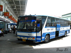
Left: The famous 'blue and white' Bus 81 to Kanchanaburi. There is actually a loo at the back of the bus, typical of Thai travel coaches.
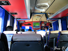
Right: The interior of the bus. Surprisingly, there was a stewardess on the bus, serving us free drink (a bottle of water) and collecting the rubbish (including the bottle, finished or not) before the destination. She was well-dressed, in blue office suit and skirt, more so than the air-stewardess on our budget airline. I decided not to take a picture of her when Cheng Cheng said I might get beaten for that.


The bus took around 2 hours to reach Kan. I think we were the only tourist backpackers on the bus; most of the passengers got down before the terminal and not carrying any luggage.

Overall it was an enjoyable journey on Bus 81. Now thinking back, Bus 81 beats any budget airline. There is TV and loo, a stewardess on board well-dressed and not bad looking, and the free mineral water was a rather kind gesture to me. At 112 baht, Bus 81 is a good bargain, truly a no-frills ride.

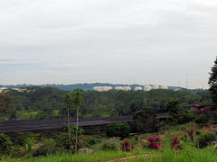
Welcome to Kanchanaburi!