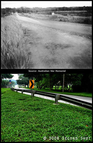
From Australian War Memorial, caption reads:
SINGAPORE ISLAND, STRAITS SETTLEMENTS, MALAYA, 1945-09-30. THE CHOA CHU KANG ROAD NEAR BULUM VILLAGE WHERE TROOPS OF 2/29 INFANTRY BATTALION SET UP AN AMBUSH AND REPULSED AN ATTACK BY THE JAPANESE ON THE MORNING OF 1942-02-10.
This is the original stretch of Choa Chu Kang Road outside Tengah Air Base (gate visible in the background, on the left). From second shot, the road has been widened, land taken from the left (airbase) side. Two reasons why I’m fascinated with the second shot.
If you look carefully at the 1945 photo, just before the road becomes straight from the right bend in the foreground, a hump is visible (look carefully at the ‘kerb’ on the right). The hump has survived all the PUB work, if any, along the stretch and is visible in my second shot.
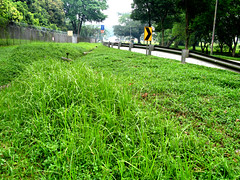
The 1945 photo shows tall grasses growing on both sides of the road. The second shot shows the grasses immaculately trimmed. But take a step back and voila, you see tall grasses like the ones in the 1945 photo:
NParks has a Heritage Trees Scheme promoting conservation of our trees. I’m not a tree hugger but I simply love the historical aspect of the scheme. According to their website (emphasis by me),
Some of the Heritage Trees were planted in parks, along roadsides or in gardens many decades ago, while others may have been self-sown or are remnant forest trees that had been retained despite the rapid urbanisation of Singapore.My search for the remnant nutmeg trees inside the Istana was a failure. But I may have serendipitously discovered the remnant roadside grasses of Choa Chu Kang Road.
On the gentle hill slope in the background of the 1945 photo the new Keat Hong Camp would be built. Back in 1945, the British Keat Hong Camp was at Choa Chu Kang Road but east of this location. That camp was later taken over by a SAR (Singapore Armour Regiment) unit. I have blogged about the stretch of Choa Chu Kang Road outside that camp. The camp has recently shifted to its current location at Tengah. You can see the camp in my second shot if not for the trees blocking, on the right side of the road:
Thus Keat Hong Camp has always been located along (original) Choa Chu Kang Road.
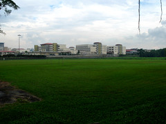
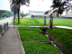
Of historical interest are the remnants of an old gate opposite Tengah Air Base. I’m not sure what it was used for, maybe oldies like Peter can tell me. Today the land behind the gate is a playing field (you can see a goalpost in the previous photo). The ‘no entry’ and ‘protected place’ signs are still hanging on the gate pillar. What anachronism!


16 comments:
I am afraid I cannot remember what was exactly opposite Tengah Airbase, but if your readers are interested, they can see a 1969 photo of me taken at the entrance to what was known then as Royal Air Force, Tengah.
However, I do know that a little down the road towards Jalan Bahar, there used to be a kampong. There was a market and hawker centre where you can see from the main road.
Sorry, forgot to insert the link to my 1969 photo.
John Harper mentioned in his comments here that the land outside Tengah Air Base was mostly vegetable farms.
On the street directory, the land opposite the air base is marked soccer field.
Just before the cemetery is Teen Challenge Dare Center and Jalan Sabit/Jalan Berseri. The market and hawker center could be situated there.
I was at TAB around mid 80s till I ROD at 88. I was still there throughout my reservists training.
Opp. the TAB is the hawker centre and on the left is the petrol station. Just before the hawker centre, is Hongkah Lane where you could drive thru all those kampong with veg. farm, and tropical fish farm like goldfish, angel fish, etc..
When driving thru this long and winding Hongkah Lane, you may sometimes see those 'road runner' dashing across the road. Of course there were some real beauties staying in those kampongs too.
Gone are those beautiful memories when we went back for reservists in the later part.
You know I have been trying very hard to recall what the old CCK Road was like. In spite of cycling throughout the length of it in 1969, and driving past it occasionally in my working days, I still cannot remember much. It is so frustrating.
I do know that there were a lot of trees and old shops. I remember visiting a modern egg farm called Seng Choon Farm in the 80's when I was working in NPB. We accessed it from a side road which sloped downhill, crossed a river and then up again in the north direction.
But as in the case of the Thomson Rd when I blogged about it, many forgotten details came back after other readers shared their memories. Hope some of your readers will do that.
> Hope some of your readers will do that.
lol .. most of my readers are also your readers in GMY. In fact GMY is the top advertiser, according to Google Analytics.
Interesting post about Tengah Air Base.
My friend happens to worship at the nearby Calvary-Tengah church. The road towards the area couldn't have been more isolated and forbidding, with no tresspassing signs everywhere.
Great good job on the second shot of the road and the heritage grass! Preserve those memories before it's all turned into condominiums.
Samuel
Thanks for the encouragement again, Samuel.
I think we better take pictures of old Chua chu Kang road now. The whole road from Sungei Tengah rd to jalan bahar is being widened, and Development has made itself felt! Already some trees have been chopped, forest has been cleared, and I fear the teen challenge opposite the air base will go too... :(
Hi Visqueraient, thanks for the heads up! Yes, we better document Old CCK Rd before it is too late ...
Heads up on the widening of Old cck road. I don't think anymore trees are going to be chopped, but the construction is proceeding quite close to the tree near the mosque (a strangler fig, I think). I think the road will only run closely beside. So maybe it'll be saved after all. But on a high note, they are preserving the old bus stop architecture!! Nearer the Lim Chu Kang end, they're rebuilding the bus stops in the old style! Using wooden scaffoldings and molds. =D
I was passing Keat Hong Camp recently. ALL DEMOLISHED.
The teen challenge building used to be a school. Anyone knows the name of the school? Thank-you.
Chua chu Kang primary school in the 80s. Before that is Chua Chua Kang Chinese primary school.
From what I can recall, from the start turning right from Jalan Bahar, we will pass long the Teens Challenge (used to be old CCKPS), continue further down, will reach the a row of dormitory with the pair of gate, in front of it is a soccer field, after which, we will reach the foodcourt and market, further down, a row of shophouses(with houses in it), further down there used to be another primary school which nam sam school (south view primary school). continue down the road, we will be seeing the 2 camps, firstly will be Old KHC1 and the next one. Hope this help :)
Post a Comment