The current entry is part of a series of articles on my first overseas Second Shot project, undertaken in August 2008.- Prelude: A Dream Up North
- Photo Essay: H-Hour 0630
- Kanchanaburi: First Look
So I have overran my objective at
Suvarnabhumi.
That wasn't too hard. Tiger came to a stop. I sashayed across the
jetway and got my
red book chopped. That was it.
The Kingdom of Siam lies in front of us.
********************
And so is uncertainty and the fear of travelling in a foreign country with people speaking a different tongue. Luckily we planned for our missions before the trip and now standing on foreign soil, we have some ideas what to expect and a rough schedule to follow. (Eisenhower said plans are useless but planning is indispensable, so our plans are not set in stone.)
By now you should have guessed, we are going to Kanchanaburi. This will be our home for the next three days. So Victor got it right in the
blog comments. =)
Before I reveal the success or failure of my second shot attempts, let me present an intelligence briefing on Kan (as we fondly refer to Kanchanaburi). If you are planning to go Kan, I hope this article is of some use to you. Ultimately this is but a debrief exercise for me. I hope to organize my knowledge in a coherent form and by recording it down, I can see how much I have learnt about the place after the trip. A written record will be useful for future missions too. The information presented is accurate to the best of my ability but I accept responsibility for any error. Feel free to comment/correct.
********************
Kanchanaburi is the name of the
third largest province in Thailand after Nakhon Ratchasima and Chiang Mai. Coincidentally its land area is almost identical to Johor's - 19,480 km² v.s. the latter's 18,986 km² (Singapore is just under 700 km²). But unlike Johor whose capital city is Johor Bahru or JB, the capital of Kanchanaburi Province is also known by the same name. Kanchanaburi Town will be the focus of this article.
Size Does Matter (and what it means to be within a foot walk)One intel failure, agreed by my travel partner also, is that we have underestimated the size of Kanchanaburi (Town). It is easy to understand why. On the net it is hard to find a good map of the town with distance indicated. When we finally found it, we were 'misled'.
The map we found came from the
website of our guesthouse accommodation. Study it closely and read the accompanying description from the website.
 The website description - Because of the central position, our guests can reach the famous Bridge over the River Kwai, the war cemetery, the Thai-Burma Railway Centre (TBRC) and several other local attractions within a foot walk.
No sweat! The attractions are all within a foot walk. On the map, it looks like you can even leopard crawl to and back with ease. Ok, I'm joking.
But no exaggeration here. On the map, the roads are straight, the surrounding barren and the labelled landmarks are within walking distance. A walk to the attractions feels like a stroll in the park. That was what I thought, really.
Now, let me show you what all the guidebooks and websites in the world won't show you - a "down to earth" comparison with Singapore.
 Courtesy of Google Earth. Top is Kanchanaburi Town and the bottom Singapore City. Both are at eye altitude 2.24km. A stroll from the War Cemetery to the Railway Bridge is equivalent to a walk from Bugis Junction to URA Centre. In case you are not familiar with Singapore, the distance spans three MRT (subway) stations.
Now, the distance looks more daunting. It does not feel like a stroll in the park anymore. The journey from Bugis to Maxwell Road along North/South Bridge Road (大马路), on pavement, takes you under trees and buildings. In Kan, no pavement exists in most places and there is paucity of shade or shelter. Under the punishing weather, you feel like a participant in a death march.
To be fair, let's examine maps from other advertising sources which I got in Kan.

 Top is from a small advertising booklet on Tasty's Cooking School. Bottom is from a booklet on Pong Phen Guesthouse & Bungalows. Both use the same map template. The distance from the War Cemetery to the Railway Bridge still looks pretty manageable here.
Let's do a small exercise to exacerbate the confusion. Look for the train station on the two maps I scanned from Kan. Pretty much the only similarity is that it lies below the railway. They don't agree on how far it lies from the end of the railway bend. The first map shows the station as just below the end of the bend, the second one a bit further. Now look for the War Cemetery to its bottom right. Once again, the maps differ; the cemetery is much further away on the first one.
Which one is correct? Neither one of course. If you have been to Kan and your memory is still fresh like mine, you'd be amused at the exercise. The maps are quite divorced from reality. On the Google Earth aerial further up, I have marked the location of the War Cemetery. The ramrod straight road just above the cemetery is Sang Chuto Road. Further up is the railway. Notice the railway bend is so much further away than on the two maps. And the quite funny thing is, you can't even find the part where Sang Chuto Road suddenly bends.
What does all these tell you? Not that they are deliberately deceiving us of course. For the record, I stayed in a
wonderful guesthouse (photos in future article). In the first place the maps are not marked as to scale. Their purpose is to show the landmarks in relation to one another, for that they are pretty accurate. Just as we should not stereotype Japanese girls to look like anime girls, those maps are not meant to be studied like a street directory.
When the website states "attractions within a foot walk", nothing could be further than the truth. The truth is that as Singaporeans, we have a Garden City - pavement lined with lush greenery, well-paved roads and because of our unique architectural tradition, we have shophouses, under them runs five-foot ways doubling as walking path and providing shelter. I find none of them in Kan. A journey from the War Cemetery to the Bridge will find yourself walking on the road, under a merciless sun, darting around stationery vehicles and electric (telephone?) poles and trying to keep a safety distance from moving cars or bikes. Don't ask me how long that will take. The furthest we walked was from the Bridge back to our guesthouse. Let's just say I was thankful it was done at night.
Free and Easy to KanchanaburiThis is almost an oxymoron. When things are free or flexible, they are not always easy. The "free" part comes at a price. Whether it is reading the latest Lonely Planet or surfing TripAdvisor, research is necessary if you don't want any nasty surprise. This research, I feel, is a price worth paying for. You learn a lot this way.
At 128km from Bangkok and linked by highway, Kan is readily accessible from the capital via car, bus or train.
A cab from the airport or city will be in excess of a thousand baht, exceeding our budget. One cab driver quoted us 2000 baht after we told him we were heading for Kan. We were in his cab heading for the bus terminal when we engaged in small talk and blurted out our destination. He told us he could drive us to Kan at that price. His reply was as confident as his driving. I became nervous. The small talk was not conducted in the most perfect conversant English but a smattering of keywords like 'Kanchanaburi'. What if he thought we wanted to change course and go Kan? I declined politely and he took the cue.
A train ride to Kan was considered because tickets are cheap (100 baht/pax) and experience novel. However the
travelling time, around 5 hours, put us off. Furthermore there are reports about the train being late, not good news considering our tight schedule. In any case, much as I relished a railway journey, the risks are too great for the payoff. The option was scrapped but I still got my train ride and if you persevere to the end of this blog series, you will get to see my pictures and videos.
So we took the bus. Getting to the bus terminal was an adventure in itself. We did not travel straight to the bus terminal from the airport because Cheng Cheng had to settle his stuff at Asoke. To get to Asoke, we took the Airport Express bus. The last time I took an 'Airport Express' bus was in Hong Kong, but that one was a double-deck. I don't remember seeing any double-decker in Thailand.
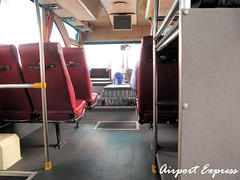
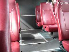 Left and Right: Interior of the Airport Express bus AE3 that took us to Asoke. Surprisingly the bus was empty except for us and one other passenger. There are four Airport Express routes (AE1 to AE4) serving the major hotels in the city. The cost is 150 baht. Of interest is AE2 ending at Khao San Road, the backpacker heaven in Bangkok.
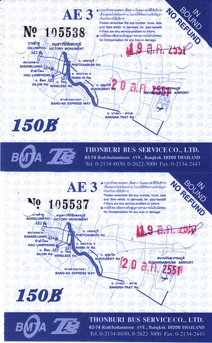 Our AE3 bus tickets. You can see the correction made on the chop for the previous day. Does this mean business was not good and tickets were over-indented?
At the shop in Asoke we discovered, to our amazement, that the shop assistants did not understand our destination. Make no mistake, they understood and spoke English comfortably but were puzzled at the mention of "Southern Bus Terminal". Eventually Cheng Cheng managed to get our destination across and they were kind enough to write us a note in Thai. The bus terminal's name in Thai is "Sai Tai Mai".
We are now in the cab earlier in the story. Other than the 2000 baht episode, the journey was memorable for his "zhng" ride and skillful driving. The engine, with its low purring, reminded me of a souped-up vehicle and its performance somehow confirmed my suspicion. The journey itself was quite long and took us under many long and beautiful bridges. The total metered cost was around 200 baht. Sai Tai Mai is quite far from Bangkok's center of action. It lies outside the
Bangkok Metropolis Map. Check out
cell A1, the upper left corner of the map - the terminal lies outside this region.
 Courtesy of Flickr member sakichin - photo of Sai Tai Mai. We were searching for the Kan ticket counter frantically, so no mood to shoot pictures. The building was really new, I read that the bus terminal shifted quite recently but confusingly both old and new terminals are called Sai Tai Mai, if I remember correctly. I believe we went to the new terminal.
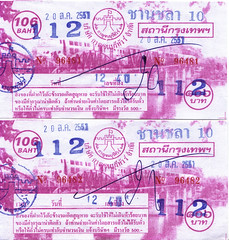 Our Bus 81 tickets to Kan. Departure time 1240. I think the official price is 106 baht but we paid 112 baht. This may be the much-touted 'farang price'. Or the extra baht may be for the free drink on the bus. (Note the Thai Buddhist Calendar used - year 2551 - which you can find on the AE3 bus tickets too. Thanks to Johnny who pointed it out)
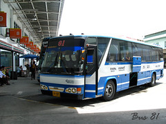
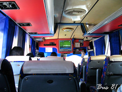 Left: The famous 'blue and white' Bus 81 to Kanchanaburi. There is actually a loo at the back of the bus, typical of Thai travel coaches.
Right: The interior of the bus. Surprisingly, there was a stewardess on the bus, serving us free drink (a bottle of water) and collecting the rubbish (including the bottle, finished or not) before the destination. She was well-dressed, in blue office suit and skirt, more so than the air-stewardess on our budget airline. I decided not to take a picture of her when Cheng Cheng said I might get beaten for that.The bus took around 2 hours to reach Kan. I think we were the only tourist backpackers on the bus; most of the passengers got down before the terminal and not carrying any luggage.
Overall it was an enjoyable journey on Bus 81. Now thinking back, Bus 81 beats any budget airline. There is TV and loo, a stewardess on board well-dressed and not bad looking, and the free mineral water was a rather kind gesture to me. At 112 baht, Bus 81 is a good bargain, truly a no-frills ride.
Welcome to Kanchanaburi!


