Thanks to Chun See's
kind recommendation, I'm now on this mystery as well.
For those who have not read Chun See's blog articles on the mystery, you can go
here and
here. There is also the forum where a discussion is held among old British soldiers ('lau pengs') on the same topic which you can read it
here.
To summarise, there are actually two mysteries - the location of H Sub Section and the location in Roger-Hatchy's photo. Or is it? Can they be the same mystery after all, with Roger-Hatchy's photo showing the location of H-Sub?
Like Chun See, the mysteries are also driving me (chest)nuts. I have been thinking of them over the weekend, poured over maps and executed a "second shot" mission to recce possible sites.
The process is nothing short of exciting. Here I thank Chun See for giving me the idea for the mission and I definitely agree with Peter when he
said,
"Wah this is so exciting trying to find old places."Two things can be confirmed about the mysteries. Both locations were in the Tengah area and both gun deployments happened in the 1960s. If you were not around in the 1960s like me, you may be disadvantaged when trying to solve such mysteries. So without further ado, let me bring you back in time, to the Tengah area of the 1960s ....
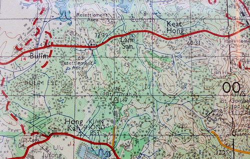
Tengah Area, circa 1966
Before we look at the 1960s version, let's see how the area looks like today. A quick (and small) one.
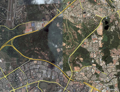 Courtesy of Google Earth. Highlighted lines are major roads. Start at Tengah Flyover where PIE joins KJE (near the left edge). If you are a driver or a resident in the area, the rest should be easy. Clockwise from Tengah Flyover, Tengah Airbase, the residental estates of Choa Chu Kang, Teck Whye, Bukit Batok, Jurong East and Jurong West (separated from its East sibling by a vertical canal).
In the 1960s, the residential estates had not existed. Neither were there PIE nor KJE. Instead life was concentrated in the kampongs located along the milestones of Choa Chu Kang Road and Jurong Road.
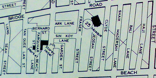
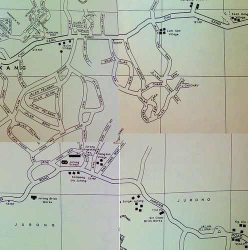 From Street Directory, circa 1966. Choa Chu Kang Road at the top, Jurong Road at the bottom. Note the kampongs alongside.
So we have the old and new map of the area. In 40 years much have changed. For example,
Hong Kah Village is gone and the name today is mostly synonymous with the
electoral boundary. Thus with respect to the boundary set by the government, the maps do not actually show Tengah but Hong Kah. But because the old British soldiers take Tengah as a reference (the runway of Tengah Airbase was a prominent landmark from high ground), and that happens to be the locality name they remember most vividly, I will call the area Tengah.
As part of my second shot hobby, I like to find traces of old roads and imagine how they looked like before they got realigned or expunged. Unlike the oldies, I have no recollection of the old roads so I can only imagine. Luckily digital tools can help us bridge the gap.
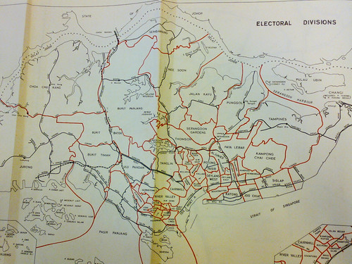
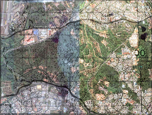 Overlay of a 1966 topographical map on Google Earth.
Looking at the overlay, I can finally trace out Choa Chu Kang Road or what was once it. From Tengah Airbase, the current Old Choa Chu Kang Road is the old one. At Track 14, it cuts across the KJE diagonally, parallels Jalan Lam Sam and the canal bridge, cuts the flats around Blk 462 and the field beside Avenue 5. Then at Old Keat Hong Camp I, I think it goes into the camp compound. In any case, it links up with Avenue 1 after the MRT underpass outside Camp II, cuts the field opposite Keat Hong LRT Station and finally links up with Choa Chu Kang Road at Teck Whye LRT Station.
Exact Location of the Roger Hatchy Photo
Do you know where is this place? Note that the photo is over 40 years old.
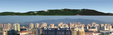
 The photo posted by Roger Hatchy in the forum. This and more photos in his Photobucket.
Having lived in the Chestnut Drive area for 25 years as a child, Peter was quick to point out the 'mountain range' as Bukit Gombak. In particular, he recognized RAF Gombak radar station on the ridge. According to him, this is the view of Bukit Gombak from the Choa Chu Kang side.
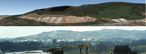 Top: Google Earth Terrain showing Bukit Gombak.
Bottom: The mysterious mountain of the 1960s from the Roger Hatchy photo.Dear readers, what do you think?
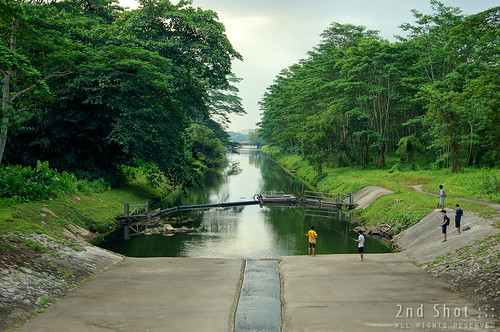
To verify my hypothesis and to get a feel of the land, I executed a second shot mission. The plan was to walk along Track 22/Jalan Chichau/Jalan Lam San and survey the terrain, noting any possible targets. This seems to be the only road that cuts through the jungle mass between PIE and KJE. Then I would cross KJE to reach Jalan Lekar and check out Chun See's hypothesis as well.
Not sure why, but I sensed some of the passengers looking at me weirdly when I alighted from 174 at the Track 22 bus-stop.
In the Roger Hatchy photo, the camera seems to be facing Bukit Gombak perpendicularly and the
saddle is at the center of the picture. Looking at the topographical map, there are two likely locations. The first is West Bukit Timah 117 and the second is Hill 140. I think I might have climbed up 117 located on the left side of the road. However the trees have grown quite tall and I couldn't even see Bukit Gombak, though I caught a glimpse of a tower (on Bukit Gombak) through the canopy. 140 is located at the end of the road that crosses the canal. It is unmistakable, the road cuts through a big field and there is even a road up the hill. Unfortunately, wild dogs guard the end of the road. I was scared so I turned back.
 Topographical map of 1966 showing West Bukit Timah 117 and 140. Standing on these hills, you will face Bukit Gombak perpendicularly and the saddle will be to your center.
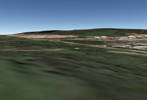 Bukit Gombak from Hill 140. Looking at the topographical map, there should be a Hill 115 in front. I think it was flattened to develop Bukit Batok West.
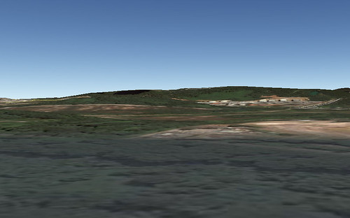 Bukit Gombak from Hill 117. Hill 140 is in front.
Location of H Sub
The only clue on the location of H Sub comes from the description of Ken Nichols in two places:
.... but when I saw the photo I immediately thought it was of my site which was located some distance to the right of the road which you would travel on when approaching Tengah from the Singapore city direction. To reach the site that I remember, you would need to follow a track leading off that main road which wound its way through a kampong and then you would negotiate a steep hill which was very difficult for the trucks to ascend until several truck loads of course gravel could be laid down. Once at the top of the hill the site had such a commanding view of RAF Tengah and the runway ....
.... it was situated some distance off the right hand side of the road that you would be travelling on if you were travelling to Tengah from the city of Singapore but I can't remember the name of that road. To access H Sub you would need to turn left off that road,.... probably about a km. before Tengah, and you would then follow the track as it wound its way through the Kampong area before eventually climbing the hill to the top where the gun was located. I remember the ascent to be quite difficult for the equipment towing Bedford trucks, and eventually it was necessary for a layer of course gravel to be deposited on the track surface to make the climb easier for the subsequent re-supply vehicles. From the top of the hill we could look down on the Kampongs on three sides but I vaguely remember being told that we should stay clear of the other side which was to the right of our position as we faced the runway at Tengah because that was the site of a cemetery, however that cemetery wasnt visible to us from the site so I never saw it ....
To summarise using Chun See's
words:
it was off Choa Chu Kang, to the right, through a kampong, and up a steep hill with no proper road; and it had a commanding view of Tengah air base and the runway.
Thus Chun See's hypothesis:
My own guess is that the site our British friends referred to as H Sub was around the Jalan Lekar/Jalan Semangka area. According to my 1963 street directory, Jalan Lekar was just a small track of the main road which was probably a kampong then, and thus fitted Ken’s description.
Peter, however, did not share the same view. In the
forum, he wrote:
Since you indicated the cemetery was on your right, then more accurately your position would have be today's "Hong Kah Road" or "Hong Kah Circle". Do the goggle search you find that the cemetery should be north of Hong Kah Flyover on the Pan-Island Expressway.
Therefore in Peter's view, they were travelling along Jurong Road rather than Choa Chu Kang road. I think this is a crucial difference that can break either hypothesis. So what was the favoured road to Tengah from the city of Singapore in the 1960s? Or did Ken take the less favoured road?
I went to the area mentioned in Chun See's hypothesis to check out the terrain. As it was near evening and I'm not cavalry, I did not manage to recce the whole Jalan Lekar/Jalan Semangka area but just Track 14. I knew about the cemetery from a friend living in Choa Chu Kang so I thought of going there to have a look.
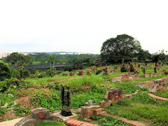
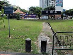
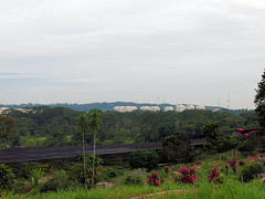 Left: Cemetery at Track 14. Background shows Bukit Gombak.
Right: Close up view of Bukit Gombak from the same position.The cemetery is on a small hill and I went to the top to take that shot. Bukit Gombak looks so small in the background, so Jalan Lekar/Jalan Semangka cannot be the location of Roger Hatchy's photo.
Conclusion
I believe I might have found the site of Roger Hatchy's photo. Of the two likely locations, I pick Hill 140. The hills around 117 are a bit far away from Bukit Gombak.; if you look at the topographical map, Track 14 lies roughly along the same vertical axis as 117, but in my cemetery photo, Bukit Gombak looks so small. I'm not sure if you were to stand on 117 with a clear view of Bukit Gombak, the latter will look much much bigger. Furthermore from 117, 220 lies in front, but in the Roger Hatchy photo, the hill in front does not look any higher than the gun hill. If it was 140, 220 would not be in the photo, instead 115 would be in front, which is around the same height as the gun hill. Unfortunately, I think 115 was flattened to make way for Bukit Batok West so there is no way to verify using Google Earth.
Comments?