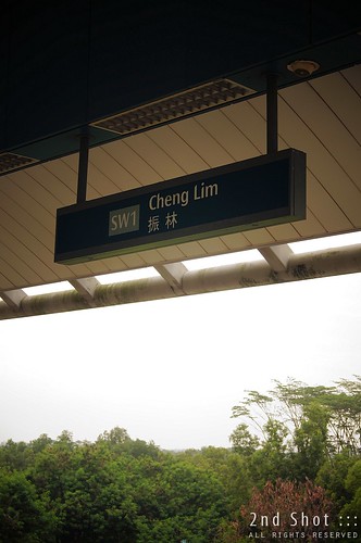
The weekend following Nomination Day on 16 Jan, we made our way to Sengkang and went around the housing estate in style - in a LRT, our first ride on the Sengkang LRT Line. Only the West Loop, i.e. half of the estate, was completed due to time constraint but still this did not stop me from alighting at one station opened for passenger service only this year. At Cheng Lim Station, located in a part of Sengkang still developing, the view to the north was surprisingly rural. As I stared at the platform signboard with the background in blur, my mind began to wander; and there and then, I wondered where was the PAP candidate's roots in Punggol.
 |
| Dr Koh Poh Koon (ST Photo) |
The Straits Times article by Jessica Cheam gave further clue to Dr Koh's roots in Punggol:
As a boy living near where the Cheng Lim LRT station now stands, he recalled with delight how he played among the pig sty and chicken coops his family kept.I did not catch the part where Dr Koh explained he was living near the site of today's Cheng Lim Station. Did Dr Koh make the association in his speeches or interviews? Or did the journalist make the association herself without verifying with Dr Koh?
In fact I am puzzled over the association of Lorong Cheng Lim where his farmhouse was located with Cheng Lim station where I alighted that weekend. I did not realize it then, when my mind was wandering at the station, that Lorong Cheng Lim did not actually cut through the forested patch today north of the station. Far from it. That was a romantic notion.
Pouring over old maps and comparing them with our current street map, I now have a better idea of the alignment of Lorong Cheng Lim including the location of its "entry point" from the main road, i.e. Punggol Road.
 |
| In an old topo map, Lorong Cheng Lim is shown as a dotted track from the main road. Where is this area in Punggol today? |
 |
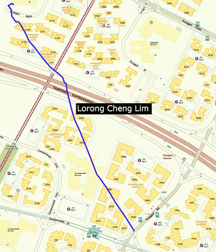
| Using a larger-scale map the track marked Lorong Cheng Lim is plotted onto OneMap. |
I'd like to believe my plot is reasonably accurate having used heritage landmarks north and south of Lorong Cheng Lim as guidelines. Even as an approximate alignment, the plot is good indication the track cut through what is today's Compassvale Green, Compassvale Sec School, Compassvale Lodge, TPE, Punggol Waves and terminating at Punggol Walk / Punggol Green Pri School. From the plot, it appears the junction of Lorong Cheng Lim and Punggol Road was located just slightly after today's Punggol Road - Compassvale St cross junction. An eating place sits at the corner (Blk 297C) today, an appropriate signpost to the old junction as your vehicle descends down the gentle slope of Punggol Road after St. Anne Church. Incidentally this would position Lorong Cheng Lim at the 9 1/4 milestone of Punggol Road (note the 15km marking on today's map). How far am I from the historical truth?
We are told Dr Koh moved to Toa Payoh around 1976 after spending three years at the farmhouse. Incidentally the 1970s was the period when redevelopment commenced in Punggol to phase out pig and poultry farming so Dr Koh and family could have been resettled by the government. How was Punggol developed after Dr Koh's time, into the late 70s, 80s and 90s before Punggol New Town?
What is puzzling from the plot of course is the discrepancy of distance between Lorong Cheng Lim and Cheng Lim Station today. According to SBS Transit on Cheng Lim Station,
This station is located very near the old road called Cheng Lim Farmway. Cheng Lim marked the area where farms were plentiful in the old days.Not surprisingly, there is a Farmway Station further down Anchorvale Street before Sungei Punggol.
On a map drawn probably in the 90s before Punggol New Town, I saw Cheng Lim Farmway 2, 4 and 5 and Track 13 marked where today we find Punggol Field and Punggol Central around Punggol Station. As I could not find these tracks on older maps, I suspect they were renamed or added after redevelopment crept in. Interestingly, Google Map also lists Cheng Lim Farmway 1, 3 and 5 and locates them between Farmway and Cheng Lim stations where a vehicle park sits today. Finally in a 1985 photo below, we are told Lorong Cheng Lim was once linked to Cheng Lim Farmway 1.


5 comments:
Your analysis is correct.
I moved to punggol in 1976. My family pig farm was at Lor Cheng Lim Farmway 1, two house away from the last photo in your blog. I was ten years old then. I am quite puzzled when Dr Koh said that he lived in a pig farm and moved out in 1976. I remembered when we were there, all the pig farms were in the beginning stage of construction. Prior to that I do not know any farms existing. Most of the pig farms were set up in 1976, and the farmers were mainly from Lim Chu Kang and Choa Chu Kang.
Hi BC, thanks. Any idea where is your house in Sengkang or Punggol today?
As for Dr Koh, he had an interesting childhood and his family could have owned the pioneer pig farm in Punggol. Hope some heritage group interview the chairman-designate for PAP Punggol East branch.
Hi guys, I used to live at 2 Cheng Lim Farmway 6 from 1978 - 1990. I also rem the last photo. I was hoping to find my old house location too.
found a link form URA too bad they nv state the exact location.
http://www.ura.gov.sg/dc/street_name/street_name(c).html
agricultural produces are having good contribution in every countries economy, Peoples are more paying attention to the farming how they can increase more and more productivity.
Well thanks for this blog posting.
Malaysia Agricultural Machinery Producers Report
This post is very interesting.
The maps from 1978 to 1995 on the One Historical Map website appear to suggest that Cheng Lim LRT is very near where the road called Cheng Lim Farmway 1 used to be. So I don't think the naming of Cheng Lim LRT is too far off geographically.
Cheng Lim Farmway 1 does not appear on the 1975 map, so it was probably built between 1975 and 1978.
From the old maps I think your extrapolation of Lorong Cheng Lim is correct, but Cheng Lim LRT is probably named for its proximity to Cheng Lim Farmway 1 rather than Lorong Cheng Lim. Farmway LRT station, which is next to Cheng Lim LRT, probably got its name from Cheng Lim Farmway 1 (or the many other surrounding "Farmway" roads) as well.
Anyway I have no ties to the area and all I'm relying on are maps I can find online so if anyone has inside knowledge please contribute!
Post a Comment