


For those who have not read Chun See's blog articles on the mystery, you can go here and here. There is also the forum where a discussion is held among old British soldiers ('lau pengs') on the same topic which you can read it here.
To summarise, there are actually two mysteries - the location of H Sub Section and the location in Roger-Hatchy's photo. Or is it? Can they be the same mystery after all, with Roger-Hatchy's photo showing the location of H-Sub?
Like Chun See, the mysteries are also driving me (chest)nuts. I have been thinking of them over the weekend, poured over maps and executed a "second shot" mission to recce possible sites.
The process is nothing short of exciting. Here I thank Chun See for giving me the idea for the mission and I definitely agree with Peter when he said, "Wah this is so exciting trying to find old places."
Two things can be confirmed about the mysteries. Both locations were in the Tengah area and both gun deployments happened in the 1960s. If you were not around in the 1960s like me, you may be disadvantaged when trying to solve such mysteries. So without further ado, let me bring you back in time, to the Tengah area of the 1960s ....
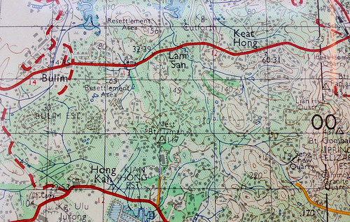
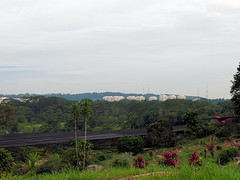
Tengah Area, circa 1966
Before we look at the 1960s version, let's see how the area looks like today. A quick (and small) one.
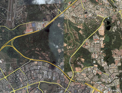
Courtesy of Google Earth. Highlighted lines are major roads. Start at Tengah Flyover where PIE joins KJE (near the left edge). If you are a driver or a resident in the area, the rest should be easy. Clockwise from Tengah Flyover, Tengah Airbase, the residental estates of Choa Chu Kang, Teck Whye, Bukit Batok, Jurong East and Jurong West (separated from its East sibling by a vertical canal).
In the 1960s, the residential estates had not existed. Neither were there PIE nor KJE. Instead life was concentrated in the kampongs located along the milestones of Choa Chu Kang Road and Jurong Road.
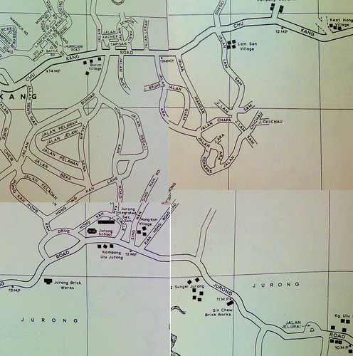
From Street Directory, circa 1966. Choa Chu Kang Road at the top, Jurong Road at the bottom. Note the kampongs alongside.
So we have the old and new map of the area. In 40 years much have changed. For example, Hong Kah Village is gone and the name today is mostly synonymous with the electoral boundary. Thus with respect to the boundary set by the government, the maps do not actually show Tengah but Hong Kah. But because the old British soldiers take Tengah as a reference (the runway of Tengah Airbase was a prominent landmark from high ground), and that happens to be the locality name they remember most vividly, I will call the area Tengah.
As part of my second shot hobby, I like to find traces of old roads and imagine how they looked like before they got realigned or expunged. Unlike the oldies, I have no recollection of the old roads so I can only imagine. Luckily digital tools can help us bridge the gap.
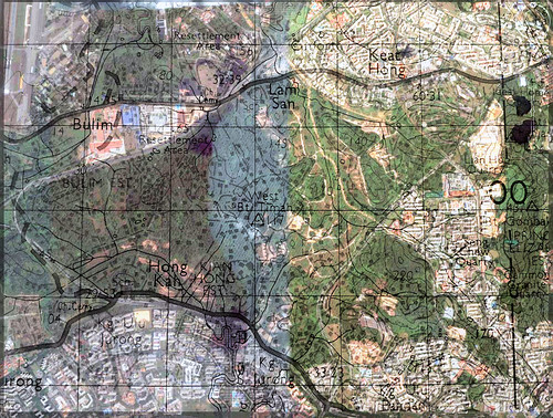
Overlay of a 1966 topographical map on Google Earth.
Looking at the overlay, I can finally trace out Choa Chu Kang Road or what was once it. From Tengah Airbase, the current Old Choa Chu Kang Road is the old one. At Track 14, it cuts across the KJE diagonally, parallels Jalan Lam Sam and the canal bridge, cuts the flats around Blk 462 and the field beside Avenue 5. Then at Old Keat Hong Camp I, I think it goes into the camp compound. In any case, it links up with Avenue 1 after the MRT underpass outside Camp II, cuts the field opposite Keat Hong LRT Station and finally links up with Choa Chu Kang Road at Teck Whye LRT Station.
Exact Location of the Roger Hatchy Photo
Do you know where is this place? Note that the photo is over 40 years old.
 The photo posted by Roger Hatchy in the forum. This and more photos in his Photobucket.
Having lived in the Chestnut Drive area for 25 years as a child, Peter was quick to point out the 'mountain range' as Bukit Gombak. In particular, he recognized RAF Gombak radar station on the ridge. According to him, this is the view of Bukit Gombak from the Choa Chu Kang side.
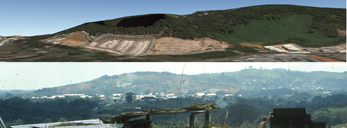
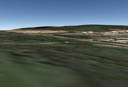
Top: Google Earth Terrain showing Bukit Gombak.
Bottom: The mysterious mountain of the 1960s from the Roger Hatchy photo.
Dear readers, what do you think?
To verify my hypothesis and to get a feel of the land, I executed a second shot mission. The plan was to walk along Track 22/Jalan Chichau/Jalan Lam San and survey the terrain, noting any possible targets. This seems to be the only road that cuts through the jungle mass between PIE and KJE. Then I would cross KJE to reach Jalan Lekar and check out Chun See's hypothesis as well.
Not sure why, but I sensed some of the passengers looking at me weirdly when I alighted from 174 at the Track 22 bus-stop.
In the Roger Hatchy photo, the camera seems to be facing Bukit Gombak perpendicularly and the saddle is at the center of the picture. Looking at the topographical map, there are two likely locations. The first is West Bukit Timah 117 and the second is Hill 140. I think I might have climbed up 117 located on the left side of the road. However the trees have grown quite tall and I couldn't even see Bukit Gombak, though I caught a glimpse of a tower (on Bukit Gombak) through the canopy. 140 is located at the end of the road that crosses the canal. It is unmistakable, the road cuts through a big field and there is even a road up the hill. Unfortunately, wild dogs guard the end of the road. I was scared so I turned back.
Topographical map of 1966 showing West Bukit Timah 117 and 140. Standing on these hills, you will face Bukit Gombak perpendicularly and the saddle will be to your center.
Bukit Gombak from Hill 140. Looking at the topographical map, there should be a Hill 115 in front. I think it was flattened to develop Bukit Batok West.
Bukit Gombak from Hill 117. Hill 140 is in front.
Location of H Sub
The only clue on the location of H Sub comes from the description of Ken Nichols in two places:
.... but when I saw the photo I immediately thought it was of my site which was located some distance to the right of the road which you would travel on when approaching Tengah from the Singapore city direction. To reach the site that I remember, you would need to follow a track leading off that main road which wound its way through a kampong and then you would negotiate a steep hill which was very difficult for the trucks to ascend until several truck loads of course gravel could be laid down. Once at the top of the hill the site had such a commanding view of RAF Tengah and the runway ....
.... it was situated some distance off the right hand side of the road that you would be travelling on if you were travelling to Tengah from the city of Singapore but I can't remember the name of that road. To access H Sub you would need to turn left off that road,.... probably about a km. before Tengah, and you would then follow the track as it wound its way through the Kampong area before eventually climbing the hill to the top where the gun was located. I remember the ascent to be quite difficult for the equipment towing Bedford trucks, and eventually it was necessary for a layer of course gravel to be deposited on the track surface to make the climb easier for the subsequent re-supply vehicles. From the top of the hill we could look down on the Kampongs on three sides but I vaguely remember being told that we should stay clear of the other side which was to the right of our position as we faced the runway at Tengah because that was the site of a cemetery, however that cemetery wasnt visible to us from the site so I never saw it ....
To summarise using Chun See's words:
it was off Choa Chu Kang, to the right, through a kampong, and up a steep hill with no proper road; and it had a commanding view of Tengah air base and the runway.
Thus Chun See's hypothesis:
My own guess is that the site our British friends referred to as H Sub was around the Jalan Lekar/Jalan Semangka area. According to my 1963 street directory, Jalan Lekar was just a small track of the main road which was probably a kampong then, and thus fitted Ken’s description.
Peter, however, did not share the same view. In the forum, he wrote:
Since you indicated the cemetery was on your right, then more accurately your position would have be today's "Hong Kah Road" or "Hong Kah Circle". Do the goggle search you find that the cemetery should be north of Hong Kah Flyover on the Pan-Island Expressway.
Therefore in Peter's view, they were travelling along Jurong Road rather than Choa Chu Kang road. I think this is a crucial difference that can break either hypothesis. So what was the favoured road to Tengah from the city of Singapore in the 1960s? Or did Ken take the less favoured road?
I went to the area mentioned in Chun See's hypothesis to check out the terrain. As it was near evening and I'm not cavalry, I did not manage to recce the whole Jalan Lekar/Jalan Semangka area but just Track 14. I knew about the cemetery from a friend living in Choa Chu Kang so I thought of going there to have a look.
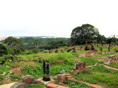
Left: Cemetery at Track 14. Background shows Bukit Gombak.
Right: Close up view of Bukit Gombak from the same position.
The cemetery is on a small hill and I went to the top to take that shot. Bukit Gombak looks so small in the background, so Jalan Lekar/Jalan Semangka cannot be the location of Roger Hatchy's photo.
Conclusion
I believe I might have found the site of Roger Hatchy's photo. Of the two likely locations, I pick Hill 140. The hills around 117 are a bit far away from Bukit Gombak.; if you look at the topographical map, Track 14 lies roughly along the same vertical axis as 117, but in my cemetery photo, Bukit Gombak looks so small. I'm not sure if you were to stand on 117 with a clear view of Bukit Gombak, the latter will look much much bigger. Furthermore from 117, 220 lies in front, but in the Roger Hatchy photo, the hill in front does not look any higher than the gun hill. If it was 140, 220 would not be in the photo, instead 115 would be in front, which is around the same height as the gun hill. Unfortunately, I think 115 was flattened to make way for Bukit Batok West so there is no way to verify using Google Earth.
Comments?


24 comments:
Okay, I'm terribly sorry but I'm going to go into one long off-topic ramble because reading this got me all excited.
It's about EXACTLY the area you captured on Google Maps - the Tengah area. I'm most interested in it because in a street directory as recent as 1991, all those roads (and a few more) were still there, connecting to Old CCK Road and I could only imagine the number of old houses and kampongs and everything that were there - you know, it's all part of that important Heritage thing the authorities keep going on about, but I was curious like HELL about it because it has all completely poofed into nowhere and appears as one large mysterious green area on current maps. Also because Jalan Lam Sam/Chichau/T22 was featured in that book "Lost Roads" and it piqued my curiosity...
Of course, you could imagine my dismay when I actually walked to Jurong Road and realised the whole area along the right side is a military Restricted Area (although I believe a part of Jalan Lam Sam off Bricklands Road is still accessible to the public). Did you really manage to walk from Jalan Lam Sam all the way down to Track 22 as you planned to?
Sorry I'm going on and on, I got so excited reading this because it was truly an experience going there. I can't believe you thought of crossing the KJE though.
Sigh, let's just say after my trip to Jurong Road I ended up in a very wrong place a few hours later. And saw more than I should have (1). And made the very stupid mistake of forgetting there was a honking expressway built since 1991.
Now that you've posted about it though I absolutely have to go explore north of Old CCK Road - I've passed that area a few times but I gotta go look around there, and in Sungei Tengah also.
Really I owe so much to people like you and Mr. Lam for making all these fascinating but exact blog posts about little-known remnants of the past - they're so exciting and it's awesome to go there and look at it yourself (or go explore some place and then it gets covered in greater detail on these sites)
Do guys in NS ever get to go to these awesome ulu places? Granted it's while they're training, but the atmosphere is so different, they're tranquil but have a lovely "deserted" feeling also because many places were dwellings once upon a time...
Anyway thanks so much. And sorry for the crazy rambling, I just couldn't help it. Wah, I wish it wasn't the exams period...
(1) Google Maps is outdated in many areas; but it is not lying about the remnants of roads in the Tengah area. Yeah.
Icemoon, that is some pretty impressive detective work. I'm in no position to dispute your conclusion, so I'd have to say that you're right!
BTW, where did you get the 1966 topo map from?
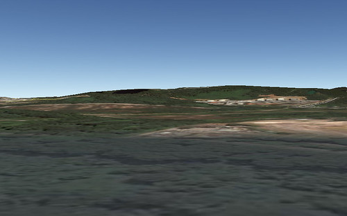
Top: Google Earth Terrain showing Bukit Gombak.
Bottom: The mysterious mountain of the 1960s from the Roger Hatchy photo.
refer to the above photos - if u move the goggle map more to the right, then u can align the slight "valley" on Bukit Gombak to the bottom photo. Doing that makes u move closer south towards Jurong Road. So the hill where the gun was located might not be Hill 140 but nearer to West Bukit Timah Hill.
Track 14 chinese cemetery is on a hill. How could a AA gun site share the same ground with a cemetery? So the Jalan Lekar area not possible.
Thank you Icemoon for another painstaking effort. But I must confess, I have a tough time following your description of the two hills; 117 and 14o. Really had to strain with the aid of a magnifying glass to see these 2 hills on your topo map.
Can I confirm that these 2 hills lie to the south of KJE near Track 22. I am afraid I have not been here before; but they seem to be too far away from Tengah to be overlooking the runway isn't it? According to one of the old soldiers, they were near the end of the runway. That's why I suspected the Jalan Lekar/Samangka area. Even Track 14 where the Chinese cemetery lies is too far away from the runway.
Anyway, I have not yet check out the area that I guessed to be the location of that artillery ... so I will need to get back to you later. But I don't think it is Hill 140 or Hill 117.
Dear Passerby. Like you I am also all excited about exploring this location. But unfortunately, unlike fit young men like you and Icemoon, there's no way I can explore these areas on foot.
Anyway, I want to address one question you raised. You asked whether we did any army training in these areas. The answer is definitely Yes. And more often than we would have liked.
In the early 70's, a lot of our army training takes place in these kind of rural areas like Tuas, Hong Kah, Neo Tiew, Marsiling and Tampines. Often, the newspapers would carry an announcement telling the public about such training and warning them not to be alarmed by the sound of thunderflashes. I did mention this a couple of times in my blogs but I didn't go into detail because I did not realize that this is something totally alien to the younger generation. Anyway, look out for my next post becos it so happens that I had planned to touch on this topic.
Let me just quote a few sentences from my previous posts to illustrate to you what I mean.
1) From my article on Where have all the wayang stages gone?
;
"I remember one occasion during my Section Leaders training when we had an exercise which was called either Fighting Patrol or Recce Patrol. We started after lunch from Safti (Pasir Laba) in Jurong towards Bukit Batok. Our RV (rendezvous point) was a wayang stage along what is now Bukit Batok East Avenue 2, near the junction with Old Jurong Road, just opposite the entrance of the Bukt Batok Nature Park. We had our dinner there and then made our way back to Safti. I recall that at that time, what troubled me most was not physical exhaustion, but an ache in my neck because of wearing the heavy steel helmet for such a long time."
2) From my article on What Melvyn missed.
"6. Seeing many places that most Singaporeans never saw, nor will ever see; from the sand pits of Tampines, to the kampongs of Hong Kah, Bt Batok, Bt Panjang, Marsiling and Kranji."
PS - As a parent of 3 school/univ-going children, I think I should urge you to put off such 'expeditions' until after your exams. There's plenty of time for these later.
Sorry Icemoon to hijack this post and side-track. Like I said before, once we lau pengs start talking about the army daze, we can't stop.
I remember one occasion when I was doing my section leaders course and we had some topo exercise in the Marsiling area (those days mainly vegetable farms). One joker in our company lost his bayonet and the whole company had to spend hours and hours searching the bushes and mud tracks and vegetable plots to look for it. Cannot remember if we finally found it or not.
Hi passerby,
Actually I'm more excited to read about your adventures. Do you keep a blog? I remember in your very first comment on my blog, you told me you already explored the beginning of the Bukit Timah siding. =)
Yup, I have read "Lost Roads" too, it was written by a lady and in quite nice prose. Nope, I walked from Track 22 up, not down from Jalan Lam Sam. And I did not complete it, I saw the canal and just followed it out to Bricklands Road.
Let's just say the mentality when you're training is just very different. Most of the time, you're just too tired or "sianz" to think about other things.
Hi. I just came back from a recce of the Jalan Lekar - Jalan Semangka area. At first I got quite excited becos the view looked just like the Roger Hatchy photo. I took a photo of Bukit Gombak from the highest point I could find; but when I got home and made a comparison, I don't think it's the right place after all. In terms of distance, it looked much further tha RH's photo.
Here's a photo I uploaded to Flickr.
http://www.flickr.com/photos/69528240@N00/2853015504/
What do you guys think?
I also checked out Jalan Lam San but it was out of bounds to public???
One day we must get together and go for another recce. Without a car, it is very difficult for you guys. But if you really want to check out the Jalan Lekar - Jalan Semangka area, I suggest you take a shuttle bus from CCC station to Qian Hu and then walk up Jalan Lekar. Its only a few hundred metres I estimate.
1. Why Jalan Lam San protected area?
2. I like to request someone make a sketch on their position relative to Bukit Gombak - there are a couple of towers. That way we can orientate ourselves from the photos taken to Bukit Gombak. Also this can be used for future references by others or for blog article. Without this sketch-map very difficult to visualise what you guys are saying.
From Cho Chu Kang side, you see 5 towers on Gombak. The 2 extreme right is at the ridge fronting Hillview. The extreme left is fronting Bukit Panjang. The short center one was where the old Raf radar station was located. If you travel up Gombak Drive to the top, assuming the Provost clear you after the railway track head up the road past the 25 pounder on display. The old radar would be at the end of the road after the road bend. If u peep through the bush between the end of the road and the bend (has a RSAF squadron unit there) in the direction of Choa Chu Kang you should be able to recognise the buildings/hills in the Tengah area. This is one way to get accurate bearings rgt?
@Lam Chun See
Don't worry Mr. Lam, I haven't gone exploring since I went down Neo Tiew Road all the way to Kranji Loop ~2 months ago. It's technically easier to be stuck at home studying anyway.
Thank you for the pointers regarding army exploration. I was just wondering if NS guys *nowadays* (not in the 70s) still get to see such places - like Ulu Sembawang (which I was reminded of after recent coverage of the Artists Village).
I guess some would... I saw a whole army drill thing going on in that fascinatingly eerie cluster of abandoned HDBs at the junction of LCK Rd and Neo Tiew Road. Very interesting to see and hear soldiers training in those run-down HDB buildings with a gloomy, dusty playground marked by a red Restricted Area sign.
I asked because my brothers who completed NS haven't really said much about having been to such places. Granted one was PES C, so he didn't see much, but the other... I guess he was, indeed, too tired and "sianz" to really care about these things. Focussed more on his missions.
Anyway I think it's precisely because some of these things feel "alien" to us youngsters that they should be blogged, or it'll become even more alien to us...
@Icemoon: I have a blog but it's mostly personal and I hardly write in it, so I'd rather not have it mentioned here.
I'm really curious to know how you went from Track 22 all the way to Jalan Lam Sam though. I thought Track 22 is off-bounds? Or did you just sneak in because there was nobody around? (It can be done *loud cough*)
Anyway, this time I've left my email in case you really want to contact me, but I assure you my "experiences" are fewer and far less interesting than yours :)
(Oh and I thought my NS question was a loud enough hint, but please let me clarify: I am neither fit (failed almost my entire PFT last year), nor a man. I'll give you the "young" though, although I definitely don't look it)
Hi passerby,
I had an enriching conscription experience, bashed through jungles, climbed mountains, crossed rivers, sat in all three choppers, took the navy landing craft (like those in Saving Private Ryan) and of course, saw those scenery "reserved" for conscripts .. hehe - Kidney Hill, Elephant Hill, and even a Hamburger Hill!!
Never trained in Ulu Sembawang before, but the Neo Tiew FIBUA Village, yes.
Actually I never walked to Jalan Lam Sam. I saw the canal and just followed it out, with the Buddhist Temple bell going gong .. gong .. in the background. LOL
There are different levels of off-bounds you know. With regards to training areas, the real off-bounds places are the Live Firing Areas. Other places, I saw civilians from time to time.
Chun See said:
Often, the newspapers would carry an announcement telling the public about such training and warning them not to be alarmed by the sound of thunderflashes.
Here's something interesting. Because conscription is conducted in English, it was not until later then I realize what those mandarin radio/tv broadcasts are saying. You hear them especially when there are exercises on the southern islands.
"演习 。。 使用空弹和雷光弹 。。"
Blanks and thunderflash! Wah leow, took so long to notice.
Peter,
The whole Hong Kah jungle including Jalan Lam Sam/Track 22 is under Keat Hong Camp, 40SAR. I'm ashamed to admit we had armour training there a few times, but I never pay attention to the geography.
Icemoon & Passerby. Did you know that the HDB flats at junction of Neo Tiew Rd and Lim Chu Road used to actual human-populated flats unlike the Fibua Village.
There used to be a hawker centre and even during my reservist days (80's) I have eaten their before. I think there are a lot of foreign workers quarters there now.
Yeah, I googled up the area when I visited it last time and saw recollections of people who lived there and of NSmen who would stop there for drinks (and their commanders would apparently lurk in the food centre to look out for anyone idling to buy drinks when nobody was looking)
It's precisely because it was a real place where people lived that it's so fascinating now that it's abandoned. (Also I had no idea what FIBUA was until googling it just now. Cool)
Eh, I figured that as long as they don't catch you it's OK for civilians to walk into restricted areas other than the Live Firing Zone, but I'm a typical paranoid Singaporean - after hearing about those people chased out from Sungei Khatib Bongsu which has the signs especially.
Didn't stop me from um... appreciating certain places though. I don't know if I want to do it again.
I'm not which hawker centre was that, but there's one inside the Neo Tiew HDB estate passerby mentioned. Now it is the resting area for the conscripts.
I can still remember the training vividly. Our block was the one to the right of the hawker centre from the main road. From the kitchen, the entire thing looks so drama. They threw smoke so the conscripts could cross from the hawker centre to the block. Then when they got to your storey, you could see what they doing through the door hole.
Passerby, actually military stuff quite fun when you read it, quite enjoyable when you watch it (like SAF Open House), but totally sianz when you do it.
Back to the place in question. You can actually walk along the canal from Bukit Batok Road to Brickland Road. Best to do it on weekend when conscripts are at home.
I don't think young girl should walk there alone. Spore is safe but still ....
Icemoon. Do you mind explaining a bit how you can get a shortof the hills viewed from horiz level through Google. Very interesting.
Yup, desolated places are not safe. MSK may not be hiding inside, but there are still mozzies, wild boars?!, wild monkeys and of course wild dogs. I am instantly reminded of this article by Chun See.
Chun See, I have finished the explanation in a new blog entry.
Hi I think the gun post photo was taken at Lim Chu Kang hill at Jalan Murai.It has a 360deg commanding view .
Hi there, come and think of it, it was during my NSF days, I did some topo exercise in lam sam area, and i can still remember some hidden knoll in there which gives u a nice view of the bukit batok area too. What i am amaze is, there are still many remnants of the past village still lying ard, for instance, we can find sweet potato, tapioca, banana plants for food too.
Yu, now that we think back, the memories are so sweet, like that sweet potato, haha. I was cursing and grumbling in my heart every time I was there for training.
Post a Comment