


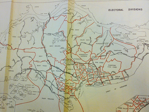
In the July 1972 street directory, there is a very important map pullout in the appendix. Here is a picture using my camera phone:
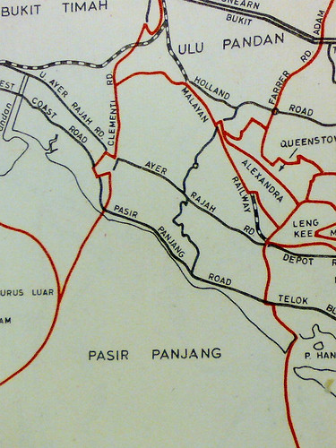
The Pasir Panjang area, enlarged:
If we compare the photo by Chun See with the area demarcated by the electoral map, it is possible that Pasir Panjang on Chun See's map is a label for the electoral division.
A bit of history. Pasir Panjang used to be a Group Representation Constituency (GRC) by itself. In 1991, it merged with Brickworks GRC to become, erm, Brickworks GRC. In 1996, Brickworks GRC was scrapped. Today the area is under West Coast GRC.
There is another possibility though.
The same street directory reveals another interesting map:
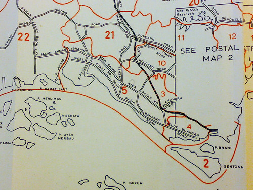
It is a map of the postal districts then. Notice how the area labelled 'Pasir Panjang' on Chun See's map is in district 5.
Interestingly, postal districts are demarcated in certain areas by the Sungei. For example, Sungei Ulu Pandan draws the boundary between 5, 10 and 21.
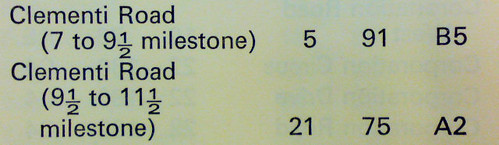
In the same street directory, two postal districts (5 and 21) divide up Clementi Road. However I notice something strange. From how the milestone is recorded, Clementi Road should start from the southern, Pasir Panjang, side, but where is the stretch before the 7 milestone??
By 1981, Postal Districts had made way for Postal Codes:
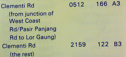
Once again, Clementi Road is divided into two. However this time, the boundary is pushed further up. Back in 1972, the boundary was at the 9 1/2 milestone which, according to the postal district map above, is just before the Clementi Road and Ulu Pandan Road junction. The milestone is not marked on the street map, so I'm making an educated guess based on the island map above.
By 1981, the boundary is at Lorong Gaung. This has disappeared, but its location is just opposite the present Corona Florist nursery. I will blog about this next time, but meanwhile do read Peter Chan's fascinating entry on it.
Back to our title question. Both my hypotheses have their weaknesses. On the electoral map, the area to the left of Clementi Road (future Clementi New Town) falls under Bukit Timah. The Pasir Panjang label, however, cuts into the area left of Clementi Road. On the postal district map, no such problem, however this time the label cuts across Sungei Ulu Pandan.
To summarize, the electoral map uses major roads to demarcate boundaries. The postal district map uses rivers. The Pasir Panjang label, unfortunately, cuts across the road and the river.


6 comments:
Wow you certainly have come up with a very thorough analysis. I suspect it's the electorial boundary demarcation becos according the my 1963 map, the electorial boundaries for Pasir Panjang is the same as what you have for your 1972 map. That means, the people who prepared the street directories did not change up after GRC realignment came about.
I can't see any of the images, they're all marked as private...
To anonymous,
Thanks! You should be able to see them now.
this post most cheem, i certainly cannot keep up with it. :(
Woh you either work in the electorial board or the National Archives of Singapore. I'm impressed!
Thanks laokokok!
But no, I work in neither. :P
Post a Comment