Pages

Mar 29, 2009

Amazing Red Dot Quiz (2) - Where can you see this mountain from Singapore?

My previous quiz on the time capsule was met with enthusiasm by fellow heritage bloggers. All of them got the answer correct by hook or by crook despite a digitally manipulated quiz photo. For quiz 2, I’m changing my strategy. The location will not be in town. I will not manipulate the quiz photo in any manner.

Since starting the blog, I’ve grown to like mountains. Thanks to blog projects like the Roger-Hatchy photo and Peter who keeps on titillating me with images of Mount Pinatubo and lady caddies. No wonder I was wild with ecstasy when the mountain appeared, like Mount Kilimanjaro, in front of me.


Now, ladies and gentlemen, where can you see this mountain from Singapore? The exact location please. Don’t say Bishan when it is in Toa Payoh, for example.

(The answer is now published in another article.)

Mar 22, 2009

Hill 100 from 500 Feet: Air and Land Survey of Hill 100 Today

Baxter

Chun See is right. Hill 100 is at the current Baxter location. :)

Because the hill was flat on top, the highest elevation would correspond to the plateau as seen in his photo from 500 feet. It was here that Chun See did his field fortification simulation exercise – Exercise Albino – in the mid 70s. The plateau is today within the Baxter compound. Therefore Woodlands Ave. 3 outside Baxter did not cut through the tip of Hill 100.

As to why the exercise was codenamed Albino, my guess is that the plateau, devoid of trees, stood out against the surrounding green from aerial observation. Indeed, aerial photos from late 60s show the plateau as one striking white patch.

Hill 100 Different Era
Hill 100, Different Era. The plateau stood out in the 1970 aerial. At first, I mistook the aerial for a CT scan or ultrasound.

But the white patch did not exist in an 1950 aerial. I do not know why the white patch exists thereafter. In his blog, Chun See recounted his experience of seeing cows grazing on a hill side along Woodlands Road and he believed the hill to be Hill 100. If that is true, then cows may be the culprit. Okay, I’m joking.

Fast forward to the present. Here is a ‘second shot’ taken at 500 feet.

Hill 100
Top: Old air photo (mid 1970s) from 500 feet showing Hill 100 with Woodlands Road in the foreground.
Bottom : Google Earth Terrain (circa. 2008) at 500 feet. Annotations by me.


I believe my ‘second shot’ is accurate because in the previous blog on Woodlands-Marsiling Road Junction, I have determined the U-turn along Woodlands Road to be where the overhead bridge is today. Furthermore, the high ground beside Woodlands Road are very similar in both pictures.

For many days, I poured over old aerials, photos and topographical maps, checking them against Google Earth, to ascertain how Hill 100 has changed over the years. In particular, I’m intrigued as to where Woodlands Ave. 3 cut the hill. The road was added to link Woodlands Road at Kranji with Woodlands New Town and later BKE.

Woodlands Ave 3
Left: Woodlands Road beside Hill 100. Map and annotation by Chun See.
Right: Google Map of the same area today. Note the addition of Woodlands Ave. 3.


Kranji MRT Station
Woodlands Road at Kranji MRT Station. Ave. 3 can be seen in the background, up an incline, cutting the contours of Hill 100.

From my research, I do not think Woodlands Ave. 3 cut through the tip of Hill 100 where the plateau used to be. From the layout of Baxter and comparison with surrounding terrain, I believe the plateau was flattened for the building of Baxter (or whoever used to occupy the site).

Baxter and Hill 100
Overlay of Google Map (satellite) and aerial photo from 1970.

Today, the highest point of Hill 100 (accessible to public) is the junction of Woodlands Ave. 3 with Woodlands Industrial Park D Street 1.

Highest Point of Hill 100 Accessible to Public
Highest point of Hill 100 today accessible to public.

It was here that I had that moment of euphoria. Walking along Woodlands Ave. 3 beside Tech Semiconductor Singapore, I noticed the slope looked suspiciously ancient. This was an area untouched by development. But not for long; the Singapore Turf Club Riding Centre is being built on the site. At the junction of Woodlands Ave. 3 with Woodlands Industrial Park D Street 1, I saw what could be the original elevation in the 1970s.

Possible Original Elevation
Possible original elevation opposite Baxter. In the blown up 1970s air photo, the 'white patch' plateau is in the foreground.


Articles in the series:
Part 1 – Was This Metal Box Company of Malaya?
Part 2 – Where (exactly) is Woodlands-Marsiling Road Junction?
Part 3 - Air and Land Survey of Hill 100 Today.

Mar 14, 2009

Hill 100 from 500 Feet: Where (exactly) is Woodlands-Marsiling Road Junction?

Around the same time the oldies were on their mission to find Hill 180 and Hill 265, I was next door in Kranji surveying the remains, if any, of Hill 100. I have no personal recollection of these hills – not having spent my conscription days sweating on them – but was intrigued by Chun See and Peter’s description of the hills and various inputs by readers.

I have covered Metal Box Company of Malaya earlier and I believe I have found the place. Today I’m moving a little south to touch on the Woodlands-Marsiling Road Junction.

Woodlands-Marsiling Road Junction, 1963Source: Street Directory of 1963.

So where is the junction today? On a 2009 street directory, Woodlands Road runs in a north-north-west direction after the T-junction with Woodlands Ave. 3. and bends gradually right to a north-east direction almost parallel to the railway track. Outside Woodlands Fire Station, Woodlands Industrial Park D Street 2 meets Woodlands Road. This may be the site of Woodlands-Marsiling Road Junction, after comparing with the 1963 street directory. We need more concrete evidence. Enters Chun See’s “Hill 100 from 500 Feet” photo.

You may like to read how Chun See managed to snap a photo at 500 feet here.

His photo from 500 feet shows the Woodlands-Marsiling Road Junction in the 1970s. I shall use Google Earth to do a “second shot” of the area today.

Woodlands-Marsiling Road JunctionTop: Old air photo showing Woodlands-Marsiling Road Junction by Lam Chun See.
Bottom: Google Earth terrain (circa. 2008) showing area outside Woodlands Fire Station. Annotations by me.


In 30+ years much have changed, but Woodlands Road in the foreground still runs towards the Johore Causeway (service 170 uses it) and the area below is still forested. On closer look, the U-turn and bus bay look like they were carried over from the past.

Nothing beats a ground observation so I made my way to Kranji on MRT and Bus 11. Standing on the overhead bridge, I commanded a good view of Woodlands Road running below.

Woodlands Road Looking SouthTop: The old air photo blown up.
Bottom: View of Woodlands Road in the southerly direction. Annotations by me.


I made the following observation:
  1. The loop that is now the bus bay existed from the 1970s (it might not have been a bus bay last time).

  2. Google Earth seems to show two rows of lane markers beside the bus bay, so they might have been erased recently (before March 2009).

  3. The road divider on the right side still has the perpendicular network of drains. The bus bay exit coincides with the second road-connecting drain from the overhead bridge and the old photo agrees with this (on the old photo, try peering through the foliage).

  4. The southern U-turn would be where the overhead bridge is now.

  5. The fence demarcates the limit of the old 1970s road divider.

  6. The pedestrian walkway is next to the kerb, but in the 1970s it was some distance from the road. In the old photo, you can see trees planted between the walkway and the road.

  7. There is a sharp bend of the kerb to accommodate a bus bay, after which Woodlands Road bends noticeably. In the 1970s, this part of Woodlands Road was smooth.

Next, the view of Woodlands Road in the northerly direction shows the northern U-turn and the junction of Woodlands Road with Woodlands Industrial Park D Street 2.

Woodlands Road Looking NorthTop: The old air photo blown up.
Bottom: View of Woodlands Road in the northerly direction. Annotations by me.


I made the following observation:
  1. Assuming the U-turn existed from the 1970s, the lane markers can lead us to the Woodlands-Marsiling Road junction. I’m assuming the marker interval remains fairly unchanged.

  2. In the old photo, there are five markers between the U-turn and the left turn into Marsiling Road. In my March 2009 photo, there are also five markers between the U-turn and the left turn into Woodlands Industrial Park D Street 2. I believe I have found the original entrance to Marsiling Road.

  3. The original exit from Marsiling Road cannot be the exit today because the triangular divider is too wide. Furthermore, the exit today is very near the overhead bridge. In the old photo the exit is pretty far from the southern U-turn (invisible in the blow-up) and earlier we agreed (I hope you do) the southern U-turn would be where the overhead bridge is now.

  4. Land was taken from the Baxter side to build the new exit to Woodlands Road. The span of Woodlands-Marsiling Road Junction is about eight markers wide, from the old photo. Eight markers from the left turn today will bring you to the corner of the triangular divider, a little short of the exit.

I believe I have found the exact location of Woodlands-Marsiling Road Junction. What do you think, readers?

Articles in the series:
Part 1 – Was This Metal Box Company of Malaya?
Part 2 – Where (exactly) is Woodlands-Marsiling Road Junction?

Mar 10, 2009

Hill 100 from 500 Feet: Was This Metal Box Company of Malaya?

Chun See’s Hill 100 post on the anniversary of the Fall of Singapore and his follow-up post got me excited over the various landmarks mentioned in the blog. He mentioned Hill 100, Woodlands Home for the Aged, Marsiling Road, Metal Box Company etc. – landmarks from the past. All of them are not on the map today. With an insatiable thirst for heritage mysteries, I embarked on my own missions to find out more about the landmarks. Besides, Second Shot has not had a heritage adventure in a long time….

Today I will blog about my search for the Metal Box Company of Malaya. The company later became CarnaudMetalbox (might be related to CarnaudMetalbox Engineering) and produced aluminium drink cans and tin cans for packaging kerosene and cooking oil, according to the oldies.

Metal Box Company Metal Box Company, 1963. Source: National Archives of Singapore.

Possible Metal Box CompanyWoodlands Road, March 2009.

I’m not sure whether the March 2009 photo is a “second shot” of the 1963 one. All I know is, when I was walking along that stretch of Woodlands Road, the coconut? trees behind the fence looked quite out of place. I don’t think these were the same trees in the 1963 photos, but this was as if nature’s way of telling me, “those trees mark the spot, dude!”

Coincidentally, if you look at my next photo, there is a bus stop just before the overhead bridge. Could this be the same bus stop in the 1963 photo but upgraded?

Possible Metal Box Company
Woodlands Road, March 2009.

Looking at the 1983 Street Directory, my location certainly looks like where Metal Box Company used to be located.

Street Directory by Chun See


What do you think, readers? Have I found what was once Metal Box Company of Malaya?

Update on March 14, 2009

This was the photo taken by yg of the old gate, as mentioned in the comments:


Metal Box Company Gate


Articles in the series:
Part 1 – Was This Metal Box Company of Malaya?

Mar 6, 2009

From Boon Lay to Joo Koon: Games, Eye Candies and Oh, Where's my Goodie Bag?

Pioneer Station - To Joo Koon
While I enjoyed myself at the Open House as a non-paying passenger, that was not the purpose of my trip. A free train ride is nothing to shout about. My real purpose was to meet, for the first time, members from the forum and to score goodie bags from the Open House. Now, a goodie bag is something to shout about because you only get it during special occasions – like an Open House. I’m hoping I don’t sound cheapskate to you.

So call my mission Operation Goodie Bag(s). However I got more than what I bargained for, as you’d see….

Elders and their Goodie Bag
Alarm bells started ringing before the 
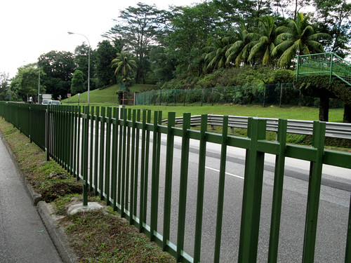
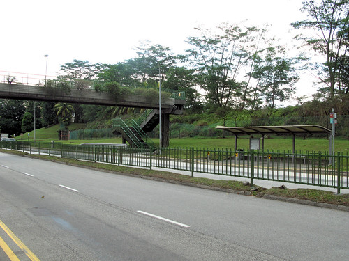
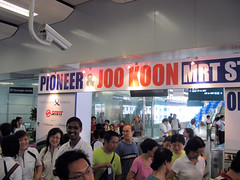
official opening at 11am. You see, we reached Pioneer Station before 11am to beat the crowd even though I didn’t expect much of a crowd. For goodness sake, this is not the Singapore Flyer where you camp overnight to get free tickets. So imagine my surprise when I saw people ………… walking about in the station!

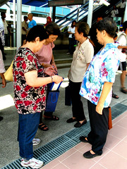
Worse, there were people already leaving the station! Most of them were elderly folks. I’m guessing this must be some smart aleck’s idea to work with the various Residents’ Committee and Elderly Groups in the event the marketing campaign fails to attract visitors. It’s show time! Picture the scene where you have happy elderly citizens walking about when the guest-of-honour makes his appearance….

I applaud whoever’s idea for some elderly/retiree cohesion and Saturday morning workout. However, the decision to present the elderly with the much-sought-after goodie bag was a bad one. I thought I saw a SMRT memorabilia when some elderly aunties inspected the content in the bag (above picture). Bad choice. Bad bad choice. They probably dumped the content to the garang-guni a week after.

Approaching Station
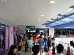
When we finally travelled up the escalator, I realized we were not the early birds. There was already a crowd in front of us as well as in the station.

Fare Gate
There was a intimidating welcoming party (wearing LTA polo tees) behind the fare gates left open specially for the Open House. They were standing about bua long long chattering with one another. I’d prefer if they formed a line screaming and shaking their pom pom on my arrival - 欢迎欢迎, 热烈欢迎!

It was here that I met and shook MP for Pioneer Mr Cedric Foo’s hand. I think he looked a bit surprised when I addressed him Sir. If I’m not mistaken, he was the Minister of State for Defence before Assoc Prof Koo Tsai Kee. Old habits die hard when you were a conscript.

Station Escalator
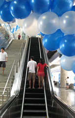
The Open House was that because you were allowed to walk around and take pictures indiscriminately. It was also a mini fun fair. You have balloons. You have joy rides. Not to forget games.

Game booths were manned by LTA staff where for no fee, you could win fantastic prizes like a sticky pad. The games were pretty creative (and I mean this from the bottom of my heart). I’m not showing any pictures, see if you can visualize the game from its pithy description:
LTA Band Live Performance
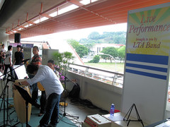
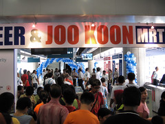
Kudos to LTA for trying to create some ambience with their Live Performance Band available at 
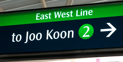
Joo Koon Station only. A pity they had stopped playing when I was there. I guess the live entertainment was necessary to cheer the visitors up, who came from Pioneer Station and suddenly realized they were in the middle of nowhere. No visible entertainment or 
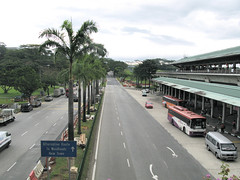
F&B outlet. Joo Koon, between PIE Pasir Laba Flyover and AYE Benoi Flyover, is an industrial area in Tuas.

Fare Gate
Interviewed
The people factor was what kept the Open House alive. I don’t mean the crowd but the eye candies. The above are eye candies staff from LTA at Pioneer Station.

Interviewed
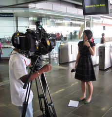
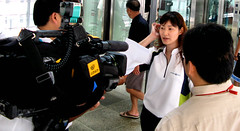
At Joon Koon Station, I had a bigger catch surprise in the form of a TV reporter for Mediacorp’s Channel 5 and CNA. I don’t know her name. Anyone can recognize her?

Interviewed
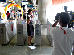
Nice dress but I’m more interested in the paper under her feet. No, she wasn’t littering. The litter paper was her script. I’m not sure whether this is a common trick employed by reporters to hide their script.

I spent a fruitful Saturday morning at the stations – taking joy rides, watching the games but not playing them, shooting eye candies etc. But oh, where’s my goodie bag?

Goodie Bag Outside
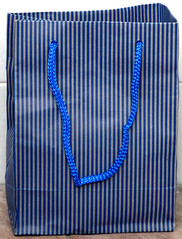
Due to unfortunate circumstances, I did not get the official goodie bag with the SMRT memorabilia. Instead I got a paper goodie bag. Do you want to know its content?

Goodie Bag Gift
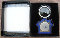
There was a LTA keychain that looked like excess inventory from HDB. So much for a SMRT memorabilia.

The Open House would be a laughing stock if the paper bag contained only the keychain. So to make the bag heavier they added something else….

Want to know what’s the additional object? Please don’t laugh when you see this.

Kudos to the organizers!

Mar 2, 2009

Our Merlion Struck by Lightning


Have you read the news?

Our national icon was struck by lightning! On the last day of February.

The original Merlion statue located at One Fullerton was struck by lightning this afternoon, causing quite a commotion.

Claire Huang caught up with some witnesses to find out what happened.

Nature sure knows how to throw a tantrum.

In its fit of anger, Singapore's longstanding original icon - the Merlion, was damaged by lightning flashes.

23 year-old Ms Swee Xueping who was having lunch with 5 other friends said the incident caused a stir.

"So we were actually sitting at Coffeebean, and then we were buying (food) and then we heard a loud thunder sound. Then we saw the lightning which was quite, it's kind of orangey and then there was a commotion, and we heard a loud noise, but we didn't know what actually happened. We were just wondering how come there's this big commotion."

A staff who wants to be known only as Mr Yap said the incident happened between 4 and 5pm.

Mr Yap who works in a shop a few metres away from the damaged statue, describes how some passersby who were stranded in the rain, dashed into the restaurant for cover.

"Something like an explosion sound, very loud. Then after that some of the pieces fell off the Merlion. All the people under the umbrella (3 parasols) ran in, towards our shop. They were scared that there'll be another thunder (lightning) strike."

Mr Yap's colleague Ms Toh said she didn't realise that the lightning had struck the statue until a customer drew her attention to it.

"I heard the thunderstorm and I saw many of the customers running into our outlet. I just heard from a customer then noticed "Hey, why the Merlion's head dropped?""

The explosion, caused by the lightening, created a hole the size of a soccer ball, on the Merlion.
But according to eye witnesses, no one was hurt.

In fact, many passersby and tourists didn't even notice the rubble on the walkway.

The statue is one of five Merlions in Singapore.

The 8.6 metre tall statue was originally located at the mouth of the Singapore River but was moved to Fullerton in 2002.


Image and report from Lightning strikes the Merlion at Fullerton.

Bad omen for the nation? You decide.

Here's a little heritage snippet from the bold sentence (emphasis by me). Do you know where are the five Merlions in Singapore?

From wikipedia entry on Merlion,

These five Merlions in Singapore are the only ones recognised by the STB:
  • The original statue at Merlion Park
  • The two-metre tall cub statue standing behind the original statue
  • The 37-metre tall gigantic replica — with Mouth Gallery Viewing Deck on the ninth storey, another viewing gallery on its head and The Merlion Shop — at Sentosa Island
  • The three-metre tall glazed polymarble statue at Tourism Court (near Grange Road) completed in 1995
  • The three-metre tall polymarble statue placed on Mount Faber's Faber Point in 1998