Pages

Dec 28, 2008

2nd Shot: Junction of Smith Street and New Bridge Road

Second Shot

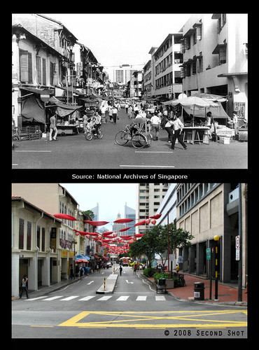
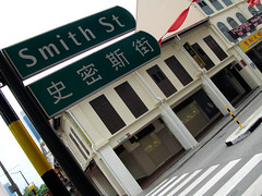
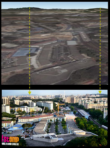
Source is a 1960 photo and my second shot was taken on the morning of March 2, 2008. You can see Chinese New Year decorations leftover from the festive season a month before.

The scene of the 1960 Smith Street is pretty comical actually. It is like a standoff between the old and the modern. On the left you have those dingy shophouses with wooden creaky windows and walls in need of a paint job; on the right the stylish flats stand stoutly with their whitewashed walls. They stare across at each other with their eyes, the windows. If we agree that the pace of development accelerated in the 1960s, then the standoff can be likened to a struggle in post-independence Singapore - will the old make way for the new? Who will outlive the rest?

Residents of the shophouses in 1960 Smith Street would be surprised to find the flats opposite gone in 2008. Their own houses, interior modernised and facade preserved, are still staring defiantly across the street.

**********

What got me interested in a second shot was the foreground building on the right. You may not recognize this nondescript building in the 1960 photo, but what if I were to show you this?

Kempeitai West District Branch

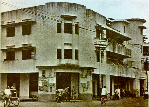
This famous photo, reproduced in history textbooks, will be familiar to those who paid a little more attention during their history lessons. You will also find it in the exhibition at Old Ford Factory which ordinary guy blogged about here.

This SIT flat was the Kempeitai West District Branch. The infamous YMCA was Kempeitai HQ as well as East District Branch. Because I've not read of any North or South Branch, the West Branch seems very high up in the hierarchy. The Kempeitai commandeered other civilian properties as well, like the White House Hotel at Mayo Street which is now Hotel 81 Rochor.

Here, I share with you some interesting observations. In both old photos, we see similar-sized advertisement plastered on the entrance wall. The one in 1960 shows the big Chinese characters 猪肉粥 (pork porridge), the 'porridge' is especially big judging from the lady in front. Below the advertisement, the wall was painted with a different colour. This colour stripe would be very prominent as it reached chest level, again using the lady as reference. I wonder how the building looked like in colour.

Next, look up and to the left, at the row of windows along Smith Street. Have you noticed the wall was actually tapered for the first two windows? But wait, here comes the most exciting part - the flower pot outside the window. It could be the same pot, barren in the older photo, but teeming with life just like the street downstairs in the later one.

**********

This shall be my last post for 2008. I hope you enjoy this second shot post and also the Second Shot blog itself. More exciting posts coming up in 2009, including the backlog of exploration and research which I've not blogged.

I wish to thank you guys for your support, especially Adelin who has been my constant reader and follower; FOYers Chun See and Victor who first started linking to me from their blogs, contributing a large part of the incoming traffic; Noel for writing the post in yesterday.sg. I wish to thank Peter also for sharing with me his research from his family history project. To all the readers, whoever you are, wherever you are, let me say a big thank you!

Smith Street

Dec 25, 2008

Old Tracks, New Trail (3) - Track Excavation at Jurong Port Road

International Business Park

My last journey took me to Teban Flyover where my wearied spirit squeezed out the remaining energy and pushed on to Jurong Entertainment Centre. There, an oasis and a cute cheeseburger marked the end of my 'infantry' mission.

That was five months ago.

Last Saturday, a kind offer from Chun See brought a few of us FOYers together for a visit to the Old Jurong Line. It was enjoyable when you got to operate like cavalry (thank Chun See for his Toyota Wish) and had running commentary from an ex-kampong boy of the trees and plants along the way. We were also treated to Peter's interesting life accounts over lunch at the former Jurong Ice Skating Rink and I'm grateful for his patient sharing of personal research on topics related to WWII and old railway. My appreciation goes to the oldies.

For me, the trip was like visiting an old friend whom you have not seen for - in this case - half a year. People change, they grow bald as they get older, but the Jurong Line landscape grows in the opposite way. What was once upturned soil is now a verdant grass patch.

Sunset Way Sunset Way
Left: Sunset Way Railway Bridge on June 1, 2008.
Right: The same place, on December 20, 2008.


Turning bald (or bushy) is just external change. We are not oblivious of what happens internally. I think/hope/believe I'm more courageous now when it comes to crossing a railway bridge. Previously I was scared stiff and the mind conjured doomsday scenarios to deter my legs from moving forward, you can read my adventure here. I have my Kanchanaburi trip to thank for in this case. I self-trained by crossing (only twice) what is arguably the most famous railway bridge in the world.

Sungei Ulu Pandan Railway Bridge
Don't stop, never give up. It helps not to look down at the river below when crossing the Sungei Ulu Pandan Railway Bridge. Chiong ah!

Some places are just too memorable to be forgotten, even when they are covered with grasses now. When I resumed my journey from Sungei Ulu Pandan Railway Bridge the last time, I started from the Ulu Pandan Park Connector. There was no way for me to get onto the track from the pavement below. So I walked until the Clementi Ave. 6 Flyover where there was a clearing. The clearing is gone today.

Below Clementi Ave. 6Below Clementi Ave. 6
Left: The clearing to the right of the railway track on July 19, 2008.
Right: The clearing no more on December 20, 2008.


The stretch after the flyover had construction activity the previous time so I had to skirt around the area. This time there was none so I could walk uninterrupted to ITE College West (Clementi). With this stretch completed, I have officially 'conquered' the Old Jurong Line between the railway bridge at Sungei Ulu Pandan and Teban Flyover.

Behind Clementi Fire Station
Walking on high ground behind Clementi Fire Station.

I broke new ground. I also saw what I thought were new landmarks. But I'm not sure, perhaps I wasn't paying attention last time.

New Bridge, Commonwealth Ave. West
A new bridge beside Commonwealth Ave. West Flyover?

I also saw new use for old landmark. I'm referring to the Sungei Pandan Railway Bridge.

Sungei Pandan Railway BridgeSungei Pandan Railway Bridge
Left: The Sungei Pandan Railway Bridge on July 19, 2008.
Right: The same bridge on December 20, 2008. Can you see what has changed?


I didn't know why the authorities were so nice as to build a boardwalk until I consulted the street directory. Fact is, the disused railway bridge is the only link between the divided Ulu Pandan Park Connector.


Original map by SLA. Label by me.

Sungei Pandan Railway BridgeSungei Pandan Railway Bridge
Left: Apologies to the lady. She had to use the sidewalk as we were blocking her way. I thought I saw the man in front turning back for her after he crossed the bridge, so sweet!
Right: FOYers, guess whose?


Railway Track Excavation


Jurong Port Road Map

After a hearty lunch at former Jurong Ice Skating Rink, Chun See led a cavalry expedition to the rest of the Old Jurong Line. One of our stop points was at Jurong Port Road where, according to the old street directory, a railway crossing used to exist. The oldies were right also in claiming, while on the way back, that Bridgestone used to stand on the current SPH Print Centre. You can see this validated by the street directory.

It was at Jurong Port Road that I saw my first track excavation.

I was excited, not over the discovery of old tracks since I already knew of a crossing at the location, but that of the nature of the excavation. Tracks do get unearthed like the stretch before Sunset Way but the digging happens on undeveloped forest floor. Coupled with the fact that the stretch is relatively well known, as least from the old street directory, the discovery, if you may call it, is not very exciting. In comparison, check out my photo of the place in September, sans excavator. A pavement was built over the tracks (that they managed to dig out the tracks prove it). That it was next to the road made it more significant.

I was reminded of railway structures turning up surreptitiously over the years, like bridge foundations during the construction of Somerset MRT and underground tracks next to Buona Vista MRT, not to forget the grand-daddy of Singapore Railway - the Tank Line - parts of it may still be buried underneath the road.

Jurong Port Road
The spot on September 21, 2008. Photo taken by me.

Jurong Port Road ExcavationJurong Port Road Excavation
Tracks and sleepers excavated.

While not an expert on railway stuff, I can still recognize a track when I see one dug out. Those in my excavation photos looked like iron pickets used by SAF or what is called in general angle iron stakes. Thank Johnny for the name.


Angle iron stake. They even felt like iron pickets when I tried to lift one up. The track actually budged! I wanted to bring a souvenir home but found nothing suitable.

Before I end, here's a short video of the excavation. The process was pretty heart-wrenching. The excavator was trying to scoop the track up but to no avail. The track just refused to surrender. In the end machine triumphed. I wonder what happened to the tracks and sleepers afterward.


Track to Excavator: Let go of me!

Dec 20, 2008

Christmas Present from NHB


Jingle bells, jingle bells, jingle all the way ....

Christmas is coming and NHB is giving out a big present:

During the Christmas Open House 2008, all entry to NHB museums and special exhibits are absolutely free of charge.

Read here.

Dec 14, 2008

A Sook Ching Centre 63 Years after the Japanese Surrender?

Hong Lim Complex

I'm not joking.

This picture was taken today opposite China Square Central. You may have visited the food centre before; I have tried their prawn noodle and fried char kway teow. But a Sook Ching Centre?!

Sook Ching (肃清) - purge through cleansing - was the systematic extermination of hostile Chinese by the Japanese military during the Japanese Occupation of Singapore. It was at such a place, a mass-screening centre, that local Chinese, innocent or not, were chosen to be massacred. If such a place still exist today, 63 years after the occupation, you'd avoid the place at all cost.

Whoever approved the direction sign should be shot, Sook Ching style. How can one mix up direction to a historical site with direction to a local amenity? I'm pretty sure historical sites have their own unique direction signs. You may have seen them in the city area. They tell you unambiguously the direction to a historical site and some even indicate the walking distance. They are also located in the open and not like the one in picture - you can see the tip almost touching the ground floor ceiling.

The historical site in question is the Sook Ching Centre at the corner of Cross Street and South Bridge Road. There used to be a monument marker near the road junction, but today the whole area was fenced up and I could not find the marker from the small opening behind the traffic light. I guess the marker was temporarily removed to facilitate the construction work going on.

Dec 7, 2008

December 7, 1941: Pearl Harbor

This eluded me until few days ago. December 7 this year falls on a Sunday, just like in 1941.

December 7, 1941 - a date which will live in infamy.

Schedule is too packed for me to release anything related to Pearl Harbor or the war. They will come in future.

(This post was pre-written and released by Blogger's Scheduled Post feature.)

Dec 5, 2008

Who's that Guy inside St. Patrick's School and St. Joseph's Institution?

While going through some recent photos in my hard-disk, I found this. Now, get ready for the million dollars question -just who is this guy?

St Patrick's School
Statue in St. Patrick's School

Picture was taken while I was at St. Patrick's School. This huge bronze statue guarded the entrance to the school building. This must be St. Patrick right?


********

Whenever you walk along Bras Basah Road in front of SAM, look to your left for sexy SMU girls right. Above the foyer, a bronze statue with fingers pointing stands proudly since the St Joseph’s Institution days. Now, get ready for the next million dollars question. - just who is this guy?

Photo Credit: acroamatic under Creative Commons license.


********

Don't fret. One more chance. If the guy is not St. Patrick or St. Joseph, then he must be the school's founder right? After all, there is a statue of Tan Kah Kee in front of the clock tower in Chinese High School as well. Guess who founded Chinese High?

Wrong. All wrong!

The guy could not be the founder of St. Patrick or St. Joseph in the sense Bishop William Oldham founded Anglo-Chinese School. This can be verified from the picture taken at the base of the St. Patrick's School statue.

St Patrick's School
St. John Baptist de La Salle (1651-1719)

Singapore was founded a hundred years after his death, you say leh?

********
St. John Baptist de La Salle

Some tidbits about our man St. John Baptist de La Salle. First, he was a French priest so the name's actually Jean-Baptiste de La Salle. Second, the 'Saint' part of his name didn't exist until his canonization in 1900 by Pope Leo XIII, so he was John Baptist and not St. John Baptist when SJI was founded (am I right?). Third, and this is why he truly deserved a place in St. Patrick's and St. Joseph's, he founded the Institute of the Brothers of the Christian Schools. Long name? Wait till you see the French - Frères des écoles chrétiennes and Latin - Fratres Scholarum Christianarum.

St Patrick's School
Forget about the long name. In Singapore (in fact U.K., Ireland and Australasia), they are known as De La Salle Brothers. Above was taken in St. Patrick's School when I was there for some business.

You can read about group's history if you are interested, like what they did and their contributions since the founding in 1680. Looking at how far they have come, I've to say it's pretty impressive. From wikipedia's last count,

Currently, about 6,000 Brothers and 75,000 lay and religious colleagues worldwide serve as teachers, counselors and guides to 900,000 students in over 1,000 educational institutions in 84 countries.

So St. Patrick's and St. Joseph's are just two of over a thousand educational institutions indebted to the movement. They are not the only ones in Singapore though. There are other Lasallian Schools as well, for example St. Anthony's Primary School and De La Salle School. Their school buildings are relatively new, so I'm not sure whether there's a nice bronze statue like the one in St. Patrick's. Heck, did they even "shift" the one from old SJI to SJI Malcolm Road?

St Patrick's School
Where is St. John Baptist pointing to?

If you observe statues of St. John Baptist, you can't help but notice the similarity - the man himself with stretched right arm and fingers pointing up, surrounded by two children and books. There's an old joke about the one at SAM, previously SJI. If you look again at the picture of the statue, it looks like St. John Baptist was telling the boy to go somewhere. Exactly where, you can find the joke in acroamatic's School Days at SJI. For acroamatic's own guess, look here.

To find out more about school days at SJI Bras Basah, read ordinary guy's award-winning blog article on his alma mater.

Nov 20, 2008

Heritage with a Modern Twist: Explore Singapore! 2008


Courtesy of Walter Lim (Director of Corporate Comms. and Industry Promotion, NHB)


As one who tries to blog about heritage creatively, I'm glad to know Explore Singapore! is back again. For the third successive year, this iconic museum event will show you a whole new side to our museums and heritage.

Take note - this is no more an event than a morsel can constitute a meal. It is a heritage buffet! Spanning over 70 activities at more than 27 museums island-wide, both young and old will be spoilt for choice, from 20 Nov to 7 Dec 2008.

Prepare to get awe-struck, star-struck, even love-struck. Not your typical museum event, the activities cover familiar lifestyle themes like food, love, shopping and entertainment - all part of NHB's efforts to bring heritage to the mass.

A gloomy economy and shrinking wallets should not deter us from taking part, as entry charges are waived or pegged at very affordable rate during this period. The kids can also indulge themselves in the activities catered for them, as do lover-birds - yes, couples are part of the target audience as well.

Here's a sampling of activities from the website. You can find more information and the full list here.

Wedding Talk by Vernetta Lopez - Wedding planner and celebrity radio personality Vernetta Lopez shares her ideas for the perfect wedding. Enjoy this special workshop with your partner in a beautiful dining hall tastefully designed by Vernetta herself. (3 Dec, SAM)

Self-Defence Workshop with Vincent Ng - Join celebrity hunk and Singapore Wushu champion Vincent Ng as he demonstrates basic self-defence moves for the ladies. Gain a basic understanding of the physical and cultural aspects of Wushu and learn leg, hand and body movements. Pick up useful stances, punches and kicks to protect yourself! (6 Dec, Civil Defence Heritage Gallery, Ladies only)

Love Tales of Bras Basah and BugisJoin us on a leisurely walk and discover the many love stories hidden within the quaint and lovely historic districts of Bras Basah and Bugis. (22 Nov/5 Dec, Singapore City Gallery)

Cosplay Challenge 09 - Come discover the world of Cosplay through our exclusive Cosplay exhibition that includes award-winning costumes from the World Cosplay Summit exhibition. Participate in our special Cosplay workshops and stand to win attractive prizes! (Singapore Discovery Centre)

Comics and Superheroes Exhibition - Explore the fantasy world of make-believe. This exhibition explores the origin and development of comics which began in mid-1600s with the introduction of caricature, gradually evolved into comic strips and books, and eventually progressed from print to screen. (4 Dec onwards, Singapore Philatelic Museum)

Screening of Princess Monoke by Hayao Miyazaki - Don’t miss cult animation favourite Princess Mononoke, a period drama set in the late Muromachi period of Japan. Based on the relationship between the supernatural guardians of a forest and the humans who consume its resources, it is a beautifully drawn masterpiece that is particularly relevant today. (5 Dec, SAM)

Marina Barrage Reservoir Cruise - Take a cruise on the new scenic Marina Reservoir! (Fridays-Sundays during Explore Singapore! period)


The highlights of Explore Singapore! are the three weekend activities - HungryGoWhere.com Big Eat Out!, Dim Sum Dollies Day Out and Wrap! Festival. The last needs a bit of elaboration. It is actually the finale event of Explore Singapore! with musical performance by Nanta from Korea, Jack and Rai from EIC and magic show by Jeremy Pei. The climax is reached when the lucky winner for the brand new Subaru Forester car (COE included) is announced. Here are the ways to win it.


Photo Credit: Yesterday.sg.
Don't need to touch the car for three days lah. Just take part in Explore Singapore! and you stand a chance to win it.

Nov 14, 2008

Recognise what mountain this is?

Came across this on STOMP:
STOMPer Albert took these photos from his home in Clementi Avenue 3, which show a mountain in the background.

He says:

"These photos were taken from my house at Clementi Ave 3, facing Clementi MRT station.

"The mountain can be seen on clear days or just after a heavy shower."

Do you recognise what mountain this is?


Singapore's No. 1 citizen journalism website with 12 million monthly page views issued this challenge arousing my interest. This heritage hobbyist with growing interest in the natural geography just couldn't resist taking up the challenge.

My initial impression of the first photo was of incredulity. With a mountain range towering behind the tall buildings, you thought when did Singapore have her own Mount Kilimanjaro? I have not had the luxury to admire the scenery from a tall building in Clementi, but I know Bukit Timah/Gombak/Batok lie nearby. This mountain, however, lies much further away. Does such a mountain exist? What can be more shocking than if you wake up one day and suddenly find a mountain on the horizon? Either you are dreaming or Uncle Yu moved the mountain (寓公移山).

But you will not find such a view in Clementi. The first photo is zoomed, so the mountain looks smaller in reality. From Albert's home in Clementi Avenue 3, you should see something like in the second photo. In the second photo, we see two mountains. The one on the left - our Kilimanjaro - is still shrouded in mystery. The one on the right looks easy with her proximity to Clementi. We'll find out in a moment.

The right one is easy, I suppose most STOMP comments got the right one right or near. By right, the challenge is with the left one, not right. So by answering the right one, how can they be right? I guess some people gave up left right and came up with Fuji, Kinabalu, Ice Mountain and yes, there's even Brokeback. They are joking, am I right?

A Brokeback Mountain in Singapore? Not anytime soon.

Do you want to find out its real name? I sure do, so we need to enlist the help of our friend again. Previously she helped me confirm the mysterious mountain of the 1960s which turned out to be Bukit Gombak.

Get ready to be excited. Firing up the client, you can't wait for the globe to rotate to Singapore. You know where you should stop from the position of Clementi MRT Station in the photo. You pan to the location, descend to the approximate elevation and look straight at the horizon, expecting to see the mountain on the left. If you don't, then perhaps the mountain was built out of a mole-hill before Google could update the map.

I did find my Kilimanjaro on the horizon after some adjustment. I almost missed it as the mountain disappears at low elevation.

Clementi Google Earth
Google Earth view of the photo. The two mountains can be seen clearly.

I was off to the mountain - flying like Superman to the destination - the moment "Kilimanjaro" appeared in sight. Even Superman takes time to fly, so in the meantime let's take a look at the mountain on the right which we have neglected. Look carefully, there are actually two of them, two hills to be exact.


View Larger Map
Line of sight to the two hills. It is easy to find Albert's place from the MRT station in the photo. This will be our origin point. From there, extrapolate the line of sight to the hills in the general direction.

Sorry to disappoint the Bukit Timah supporters. You are mistaken if you think the Tin Hill is one of them.

Ok, Superman should have reached his destination now. Ooh, and with the realization he is in Malaysian airspace. Superman boleh! Needless to say, our superhero does not need a passport.

Gunung Pulai from Clementi
Top: The mountain at close range, from Google Earth.
Bottom: The mountain in the background of the photo.


So where is this mountain? I give you a clue - it is pretty near a resort with golf course. In fact I was at this resort quite recently.


View Larger Map
Line of sight to Bukit Gombak and the mountain.

Nov 5, 2008

A Lorong is not a Street: Taxonomy of the Singapore Road Name


Given the plethora of online resources and services, do you still use the paper street directory?

While people are flocking to Google Map and SLA Map, there is a reason why I still hug my street directory book and even bought the latest edition recently.

There are things that you just cannot find on the paperless version. The road index is an example. Gone are the days you have to scan the index for your road, the online version like SLA Map provides a search box for that purpose.

The street directory from a certain publisher contains a real gem - their road index is in dual language. This, I thought, is a good chance to brush up my Chinese. Yeah right! Actually I'm lying. My English is the one to be brushed up, as far as the taxonomy of road name is concerned. You can't fault me for this - I had English and Chinese as first language in school and now with really talented Mainlanders working under with me, my working language is by and large Mandarin.

Disclaimer: My Chinese is by no means fantastic. What follows is a hodgepodge of guesswork.

If you do a classification on the road index, you'd realize there are more than two dozens ways we name the Singapore road. The list is shocking, you never thought Boat Quay and Boat Quay Lane are different roads in the index.

Taxonomy of the Singapore road name. Here are 22 most common and more interesting ones. The full list could be double the number.

There is no one-to-one translation between the English and Chinese road name. Is this any surprising? There is a sociopolitical reason behind this and I shall not elaborate. There is also the linguistic reason English "borrows" heavily from its cousins across the Channel.

Take Boulevard for instance. The word is suspiciously French and I never bothered to check the meaning from the dictionary. It sounds cool with the usual French airs. Of course it is only cool if you enunciate the French way, the same with 'reservoir' and 'rendezvous'. My ignorance disappeared after seeing the Chinese translation - 林荫道. Chey, so it is just a road lined with and shaded by trees. In fact the dictionary definition is:

a broad avenue in a city, usually having areas at the sides or center for trees, grass, or flowers.

And the translation for Avenue happens to be 道. Now I know why Orchard Road looks so different from Orchard Boulevard.

The mixing and matching leads to better understanding. A Way is a Big Avenue, so Boon Lay Way is wider than Boon Lay Avenue. A Track is a Rural Avenue. An Alley is a Small Lane. A Grande is supposed to be a Majestic Avenue, but looking at Tampines Grande I'm not so sure. A Path is a smaller version of a Walk. And of course, a Lorong is not a Street.

The Chinese translation reveals other information. I didn't know Buona Vista means "good view" in Italian until I blogged about it here. If only I read the road index more carefully a few years before, as Vista and View are pretty synonymous in the road index. I didn't know also that Vale is a kind of valley. You can call the Chinese an uncreative bunch for naming every valley a valley. That's why the Grand Canyon is called 大峡谷, just as the Dragon Girl in the Jinyong (金庸) story fell into 绝情谷.

Oct 27, 2008

Photo Essay: A Life for every Sleeper (I)

The current entry is part of a series of articles on my first overseas Second Shot project, undertaken in August 2008.
  1. Prelude: A Dream Up North
  2. Photo Essay: H-Hour 0630
  3. Kanchanaburi: First Look
  4. Photo Essay: To Kanburi with Love
  5. Second Shot: Steel Railway Bridge @ Tamarkan (I)
  6. Second Shot: Steel Railway Bridge @ Tamarkan (II)
  7. Photo Essay: A Life for every Sleeper (I)


Donrak War Cemetery


Although many years have passed since those fatal days of war,
my feeling of pride will never grow small.
To all the men and women that gave so much,
I only wish we could keep in touch.
War should not be glorified,
but to all those who fell and fought so well did not do so in vain,
as I for one will always remember them.

Signed,
A young and mighty bloody proud Australian
(Photo)


Donrak War Cemetery

1939 - 1945

THE LAND ON WHICH THIS CEMETERY STANDS
IS THE GIFT OF THE THAI PEOPLE FOR THE
PERPETUAL RESTING PLACE OF THE
SAILORS SOLDIERS AND AIRMEN
WHO ARE HONOURED HERE


Donrak War Cemetery

Donrak War Cemetery

Donrak War Cemetery

Donrak War Cemetery

Donrak War Cemetery

Donrak War Cemetery

Donrak War Cemetery

Donrak War Cemetery

Oct 21, 2008

Choa Chu Kang Road, Shopping Center, Mystery

What does the three have in common? Let me elaborate.

After my trainspotting at 10 miles Junction, I trudged my way to (Old) Keat Hong Camp at Choa Chu Kang Ave. 1 for another heritage mission. At Choa Chu Kang Way, just before the left turn into Ave. 1, something on the big field caught my eye ....

Old Choa Chu Kang Road
The old Keat Hong Camp lies behind the fence on the left. Palm Gardens on the right.

This could be it, I told myself.

Could be what?

If you stand at the road bend beside our object of interest, you'd see the two lanes merging and Ave.1 changing from a dual carriageway to a single carriageway.

Choa Chu Kang Ave.1Choa Chu Kang Ave.1
Left: In the direction of old Keat Hong Camp. The road becomes a single carriageway after the bend, the double white lines changing to a single white line.
Right: Palm Gardens on the left. The two lanes merge just before the bend.


Let's take a closer look at our object of interest. The place is state land now and dumping and burning are not allowed. However I found evidence of burning - from the seventh month?

Old Choa Chu Kang RoadOld Choa Chu Kang Road
Left: State Land - no dumping, no burning. By order, HDB.
Right: Did somebody disobey the no burning order?


Old Choa Chu Kang Road
Our object of interest in all its splendor. Erm, splendor?

Let's move on. No, I did not make a mistake. I really mean - let's move on.

The next destination was not unexpected like the first. You see, while looking at the street directory, I saw a Keat Hong Shopping Center beside Ave. 1. I thought, wah, a shopping center at the fringe of the new town. Maybe it would be like the one at Holland Village. A good place to enjoy the aircon. A good place to buy a drink. A good place to rest the legs.

That was during planning.

Imagine my excitement turning into disappointment upon seeing the real thing.

Keat Hong Shopping Centre
Let me introduce you .... Keat Hong Shopping Center! The building behind is called - unabashedly - Choa Chu Kang Market.

We have come to the last of the trio. The mystery, of which there are actually two.

The first is our object of interest. It looks like a road, or what used to be a road. The road should be Choa Chu Kang Road. It is quite sad as this once famous road exists only between Teck Whye LRT Station and Ten Mile Junction today, widened, so the stretch doesn't look original. Ironically the stretch that looks original, at Tengah, is not Choa Chu Kang Road but Old Choa Chu Kang Road. So the new has usurped the old and original.

The second is Choa Chu Kang Road as it passed through the old Keat Hong Camp I. During my search for the artillery gun, I did a (mid 1960s) map overlay on Google Earth. The overlay showed the road passing through the present camp compound. This means the 1960s Choa Chu Kang Road did not follow the alignment of Choa Chu Kang Ave. 1 outside Keat Hong Camp I. This is not altogether inconceivable as there are no buildings along the suggested path of the road. So 40 years ago, the road might have ran inside the camp. Or maybe the camp was built after that. Or maybe the camp was smaller in the past. Do you happen to know the answer?

Choa Chu Kang Road @ Keat Hong Camp