Pages

Oct 27, 2008

Photo Essay: A Life for every Sleeper (I)

The current entry is part of a series of articles on my first overseas Second Shot project, undertaken in August 2008.
  1. Prelude: A Dream Up North
  2. Photo Essay: H-Hour 0630
  3. Kanchanaburi: First Look
  4. Photo Essay: To Kanburi with Love
  5. Second Shot: Steel Railway Bridge @ Tamarkan (I)
  6. Second Shot: Steel Railway Bridge @ Tamarkan (II)
  7. Photo Essay: A Life for every Sleeper (I)


Donrak War Cemetery


Although many years have passed since those fatal days of war,
my feeling of pride will never grow small.
To all the men and women that gave so much,
I only wish we could keep in touch.
War should not be glorified,
but to all those who fell and fought so well did not do so in vain,
as I for one will always remember them.

Signed,
A young and mighty bloody proud Australian
(Photo)


Donrak War Cemetery

1939 - 1945

THE LAND ON WHICH THIS CEMETERY STANDS
IS THE GIFT OF THE THAI PEOPLE FOR THE
PERPETUAL RESTING PLACE OF THE
SAILORS SOLDIERS AND AIRMEN
WHO ARE HONOURED HERE


Donrak War Cemetery

Donrak War Cemetery

Donrak War Cemetery

Donrak War Cemetery

Donrak War Cemetery

Donrak War Cemetery

Donrak War Cemetery

Donrak War Cemetery

Oct 21, 2008

Choa Chu Kang Road, Shopping Center, Mystery

What does the three have in common? Let me elaborate.

After my trainspotting at 10 miles Junction, I trudged my way to (Old) Keat Hong Camp at Choa Chu Kang Ave. 1 for another heritage mission. At Choa Chu Kang Way, just before the left turn into Ave. 1, something on the big field caught my eye ....

Old Choa Chu Kang Road
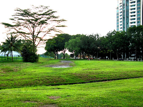
The old Keat Hong Camp lies behind the fence on the left. Palm Gardens on the right.

This could be it, I told myself.

Could be what?

If you stand at the road bend beside our object of interest, you'd see the two lanes merging and Ave.1 changing from a dual carriageway to a single carriageway.

Choa Chu Kang Ave.1Choa Chu Kang Ave.1
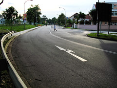
Left: In the direction of old Keat Hong Camp. The road becomes a single carriageway after the bend, the double white lines changing to a single white line.
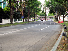
Right: Palm Gardens on the left. The two lanes merge just before the bend.


Let's take a closer look at our object of interest. The place is state land now and dumping and burning are not allowed. However I found evidence of burning - from the seventh month?

Old Choa Chu Kang RoadOld Choa Chu Kang Road
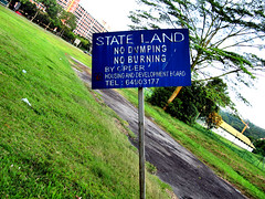
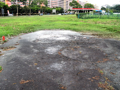
Left: State Land - no dumping, no burning. By order, HDB.
Right: Did somebody disobey the no burning order?


Old Choa Chu Kang Road
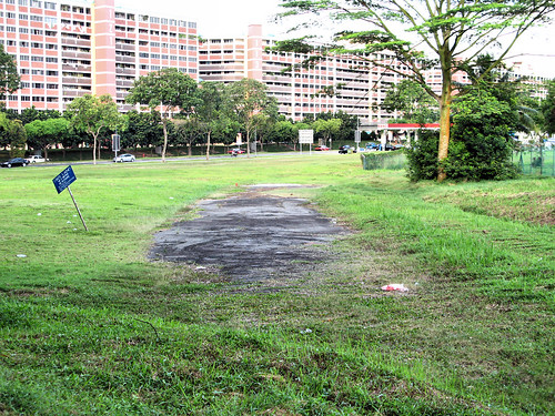
Our object of interest in all its splendor. Erm, splendor?

Let's move on. No, I did not make a mistake. I really mean - let's move on.

The next destination was not unexpected like the first. You see, while looking at the street directory, I saw a Keat Hong Shopping Center beside Ave. 1. I thought, wah, a shopping center at the fringe of the new town. Maybe it would be like the one at Holland Village. A good place to enjoy the aircon. A good place to buy a drink. A good place to rest the legs.

That was during planning.

Imagine my excitement turning into disappointment upon seeing the real thing.

Keat Hong Shopping Centre
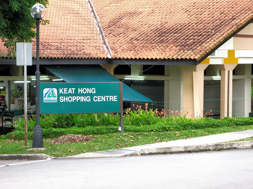
Let me introduce you .... Keat Hong Shopping Center! The building behind is called - unabashedly - Choa Chu Kang Market.

We have come to the last of the trio. The mystery, of which there are actually two.

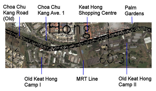
The first is our object of interest. It looks like a road, or what used to be a road. The road should be Choa Chu Kang Road. It is quite sad as this once famous road exists only between Teck Whye LRT Station and Ten Mile Junction today, widened, so the stretch doesn't look original. Ironically the stretch that looks original, at Tengah, is not Choa Chu Kang Road but Old Choa Chu Kang Road. So the new has usurped the old and original.

The second is Choa Chu Kang Road as it passed through the old Keat Hong Camp I. During my search for the artillery gun, I did a (mid 1960s) map overlay on Google Earth. The overlay showed the road passing through the present camp compound. This means the 1960s Choa Chu Kang Road did not follow the alignment of Choa Chu Kang Ave. 1 outside Keat Hong Camp I. This is not altogether inconceivable as there are no buildings along the suggested path of the road. So 40 years ago, the road might have ran inside the camp. Or maybe the camp was built after that. Or maybe the camp was smaller in the past. Do you happen to know the answer?

Choa Chu Kang Road @ Keat Hong Camp

Oct 13, 2008

Second Shot: Steel Railway Bridge @ Tamarkan (II)

The current entry is part of a series of articles on my first overseas Second Shot project, undertaken in August 2008.
  1. Prelude: A Dream Up North
  2. Photo Essay: H-Hour 0630
  3. Kanchanaburi: First Look
  4. Photo Essay: To Kanburi with Love
  5. Second Shot: Steel Railway Bridge @ Tamarkan (I)
  6. Second Shot: Steel Railway Bridge @ Tamarkan (II)


Steel Railway Bridge @ Tamarkan
Source
Record Date: post 1945
2nd Shot
Date: August 2008


This was taken from the opposite side of the bank. I'm not sure of the age, but looking at the spans that were replaced, the photo must have been taken after the war. In a future post, I will talk more about this fascinating bridge.

In the photo, the train should be travelling forward, so the locomotive was pushing the wagons. I do not know much about trains, having done my first trainspotting less than a month ago, but I think locomotives can pull (the usual setup) and push as well. If there was no locomotive at the front, then this locomotive behind was doing the pushing. Which is a bit funny. I mean, isn't this dangerous?? What if a cow is wandering on the track, oblivious to your incoming train? I heard modern locomotives can go-stun as well, so the photo might be that of an approaching train. Which is no less hilarious.

That part of the bank used to be flooded. How come the bank doesn't flood today? Also in a future post when we compare the Google Earth image with a WWII aerial photo, we see how the river has changed her course. Physical geography is interesting, don't you think so?

The photo puts me to shame, the details are so much clearer compared to mine. The hill is so clear in the background, in mine you have to stare hard to discern just a faint outline.

To get a better second shot, it is necessary to simulate the water level. For that a table can be used, which I think you can find in the foreground. Also I should have moved a bit to the left.

Oct 9, 2008

Second Shot: Steel Railway Bridge @ Tamarkan (I)

The current entry is part of a series of articles on my first overseas Second Shot project, undertaken in August 2008.
  1. Prelude: A Dream Up North
  2. Photo Essay: H-Hour 0630
  3. Kanchanaburi: First Look
  4. Photo Essay: To Kanburi with Love
  5. Second Shot: Steel Railway Bridge @ Tamarkan (I)

Steel Railway Bridge @ Tamarkan

Source
Record Date: circa 1944
2nd Shot
Date: August 2008


It is not often you get to second-shot a scene of destruction. The bridge, bombed by Allied aircraft, gave the lad in the prelude his dream.

The second shot could be better though, if I were to move towards my two o' clock. At that time, the gun sun was hot and glaring, reducing the contrast of the LCD preview. An upcoming second shot mission meant that time was a luxury. So I only took one photo of the bridge at that angle.

So you see, sometimes second shot is the art of precision heritage photography; other times it is not due to a race against time and a battle with the elements, you just press the shutter and hope for the best. In Victor's case, he was watching out for Uncle Sam on his maiden second shot.

The original of the original (huh?) does not look so eerie. No wonder the original gave the lad nightmare. I believe the original of the original should be closer to the one below which I found only a few days ago.

bridge_04

Oct 4, 2008

Photo Essay: To Kanburi with Love

The current entry is part of a series of articles on my first overseas Second Shot project, undertaken in August 2008.
  1. Prelude: A Dream Up North
  2. Photo Essay: H-Hour 0630
  3. Kanchanaburi: First Look
  4. Photo Essay: To Kanburi with Love


Ploy Guesthouse

Dear Kanburi,

It has been more than a month since I left you. How are you? I hope things are going well there.

These few days, there have been a few torrential rains at my side. Oh my, I remember waddling along a mini River Kwai in the park on my way home. It was terrible. How's the weather at your side? It is rainy season now, I remember, and Erawan Waterfall is most impressive after a heavy rain.

Oh yes, I want to thank you too for the formal introduction to the Thailand-Burma Death Railway. The first time I visited you was many years back, as a conscript. It was one of the best experience I had during those dark months. This time round, I'm glad to have travelled along the historic railway. The bridge crossing at River Kwai was memorable and so was the view from the viaduct at Wampo. The experience revived my interest in railway and trains and do you know, I have done my first trainspotting in Singapore?

The three days spent with you was as enjoyable as it was short. There was just so much to see but so little time. I could not finish covering the museums. The plan to go Hellfire Pass was aborted. Neither did I go Chungkai Cemetery.

Time was short but I had a fulfilling second shot mission exploring the old railway and the catch for second shot photos was good. With so many things to cover, there will be a next time, a second time.

Do give my regards to the lady boss at Ploy Guesthouse. Tell her I miss their toast with pineapple jam.

Before ending, I have something to confess. You are hot. You are hotter than I care to admit.

Warmest regards,
Icemoon.
Singapore.

PS: This is not what you think. No, Kanburi is not Kanchanaburi, I found this out later in Bangkok when none of the Thais I spoke to knew about Kanburi - I told them I came from Kanburi and they were like, huh? The usage is historical. For POWs, it was one of the POW camps in today's Kanchanaburi Town. Before the trip, I chanced upon the name and assumed it to be the short form for Kanchanaburi. But alas, so much for my attempt to reduce a five-syllable name to three syllables. The name will stay, nonetheless, because I just cannot find a shorter name to call a friend.


Room at Ploy Guesthouse
Our room at Ploy Guesthouse with attached garden. The beds are on this spacious wooden platform that accomodates my luggage, my bag and of course our butts. The shower is visible to the left, and from our room.


Floating Restaurant, River Kwai
The floating restaurant on River Kwai. We had our dinner the first night in this restaurant to the right of the Bridge, from the Kanchanaburi side. After a long walk from the guesthouse and my second shot mission, I can tell you the crushed ice in my lime juice was heavenly!


The Bridge on the River Kwai
The famous Bridge on the River Kwai. Less than three months after I stepped on my first railway bridge at Sunset Way, I walked across this world-renowned railway bridge. Woohoo!


Donrak War Cemetery
The war cemetery at Donrak. A short 15 minutes walk from our guesthouse, the cemetery is located next to the main road and beside a Chinese cemetery. Lying on flat land with only grave markers, this is in stark contrast with Singapore's Kranji War Cemetery. Those buried are, however, equally deserving of a place in history.


Erawan Waterfall
Erawan Waterfall. Our plan to conquer the seven tiers of Erawan was a success. It was a good workout too. The water is good for swimming and I read playful fishes love to nibble at your feet.