I have covered Metal Box Company of Malaya earlier and I believe I have found the place. Today I’m moving a little south to touch on the Woodlands-Marsiling Road Junction.
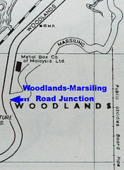
 So where is the junction today? On a 2009 street directory, Woodlands Road runs in a north-north-west direction after the T-junction with Woodlands Ave. 3. and bends gradually right to a north-east direction almost parallel to the railway track. Outside Woodlands Fire Station, Woodlands Industrial Park D Street 2 meets Woodlands Road. This may be the site of Woodlands-Marsiling Road Junction, after comparing with the 1963 street directory. We need more concrete evidence. Enters Chun See’s “Hill 100 from 500 Feet” photo.
You may like to read how Chun See managed to snap a photo at 500 feet here.
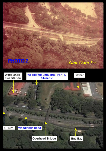
His photo from 500 feet shows the Woodlands-Marsiling Road Junction in the 1970s. I shall use Google Earth to do a “second shot” of the area today.
 Top: Old air photo showing Woodlands-Marsiling Road Junction by Lam Chun See.
Bottom: Google Earth terrain (circa. 2008) showing area outside Woodlands Fire Station. Annotations by me.
In 30+ years much have changed, but Woodlands Road in the foreground still runs towards the Johore Causeway (service 170 uses it) and the area below is still forested. On closer look, the U-turn and bus bay look like they were carried over from the past.
Nothing beats a ground observation so I made my way to Kranji on MRT and Bus 11. Standing on the overhead bridge, I commanded a good view of Woodlands Road running below.
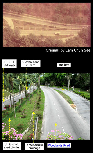
 Top: The old air photo blown up.
Bottom: View of Woodlands Road in the southerly direction. Annotations by me.
I made the following observation:
- The loop that is now the bus bay existed from the 1970s (it might not have been a bus bay last time).
- Google Earth seems to show two rows of lane markers beside the bus bay, so they might have been erased recently (before March 2009).
- The road divider on the right side still has the perpendicular network of drains. The bus bay exit coincides with the second road-connecting drain from the overhead bridge and the old photo agrees with this (on the old photo, try peering through the foliage).
- The southern U-turn would be where the overhead bridge is now.
- The fence demarcates the limit of the old 1970s road divider.
- The pedestrian walkway is next to the kerb, but in the 1970s it was some distance from the road. In the old photo, you can see trees planted between the walkway and the road.
- There is a sharp bend of the kerb to accommodate a bus bay, after which Woodlands Road bends noticeably. In the 1970s, this part of Woodlands Road was smooth.
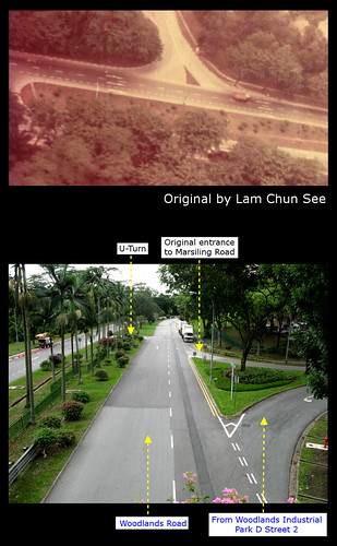
 Top: The old air photo blown up.
Bottom: View of Woodlands Road in the northerly direction. Annotations by me.
I made the following observation:
- Assuming the U-turn existed from the 1970s, the lane markers can lead us to the Woodlands-Marsiling Road junction. I’m assuming the marker interval remains fairly unchanged.
- In the old photo, there are five markers between the U-turn and the left turn into Marsiling Road. In my March 2009 photo, there are also five markers between the U-turn and the left turn into Woodlands Industrial Park D Street 2. I believe I have found the original entrance to Marsiling Road.
- The original exit from Marsiling Road cannot be the exit today because the triangular divider is too wide. Furthermore, the exit today is very near the overhead bridge. In the old photo the exit is pretty far from the southern U-turn (invisible in the blow-up) and earlier we agreed (I hope you do) the southern U-turn would be where the overhead bridge is now.
- Land was taken from the Baxter side to build the new exit to Woodlands Road. The span of Woodlands-Marsiling Road Junction is about eight markers wide, from the old photo. Eight markers from the left turn today will bring you to the corner of the triangular divider, a little short of the exit.
I believe I have found the exact location of Woodlands-Marsiling Road Junction. What do you think, readers?
Articles in the series:
Part 1 – Was This Metal Box Company of Malaya?
Part 2 – Where (exactly) is Woodlands-Marsiling Road Junction?


4 comments:
Wah .. so detail. I have to come back another time to read slowly. But more important .... is my conclusion that Hill 100 is at present Baxter location correct?
Please go to the Picassa site and view Ngiam Shih Tung's 1978 topo map. It clearly shows Hill 100. My photos were taken in Aug 1977.
By the way, I did not take the aerial photos. We went up in groups of 4 or 5 people per group. The chopper had to make several trips for the entire group of us.
The helicopter was one of the small ones with no side doors. As the chopper banked sideways, I was so worried that I would drop out becos I wasn't 100% sure I had fastened my safety belt properly. Everything was very rushed, and we being officers, the pilot never bothered to check whether we were strapped properly.
Must be the Huey (UH-1H during my time) Chun See took. Wah, Chun See did not take the photo, who's the mysterious photographer? That means somebody else in Singapore should have the same set of photos ..
Yes. I think my whole batch of trainees had the photos. As I described in my article about age of films, usually the photographer will print one set, circulate in a mini-album with the film number. Those who want to order will indicate the nos. and the guy will collate and send the negatives to shop for printing, and then diseminate to the members and collect the money.
Post a Comment