


The Singapore Airshow at Changi Exhibition Centre drew 71,000 people over the weekend. Many must have came for the heart-stopping flying displays by the display teams. Unfortunately, this year's displays were a letdown as they featured mainly single aircraft. On Thursday, an aerial display was aborted in front of hundreds of trade visitors after safety was breached - The T-50 Golden Eagle's flight this afternoon was observed to have infringed the safety boundaries and the pilot was instructed to terminate his flying display as a precaution.
At $20 a ticket, the air show was not a free event of course. Now imagine you could watch one free outside your home. Some East Coast Road residents had this "privilege" in 1951, of seeing an aircraft performing aerial stunts over their house. Unfortunately the "performance" did not end with applause nor disappointment, but shock and horror as the aircraft ended in scattered debris with fatalities.
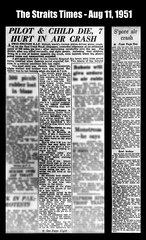
The Straits Times headline of Aug 11, 1951 reads:
A twin-engined R.A.F. Hornet, world's fastest piston-driven plane, crashed on the East Coast Road, Singapore, yesterday afternoon at an estimated speed of 200 miles per hour after performing aerobatics over the sea. The British pilot was killed instantly, and eight people, including four children, living in a row of houses opposite the crash, were injured, when the plane's petrol tanks and ammunition exploded.

Hornet F 3, c. 1948. The crashed Hornet should look like this. (Image credit: wikipedia)

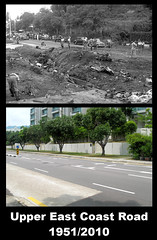
Air crash along Upper East Coast Road. Box in blue shows scene of crash. (Image credit: streetdirectory.com)
It was not to be a flying display. The pilot, Sgt. George Edmund Howson (age 27), was authorized for flying practice but turned the practice into an aerobatics display. Ace-pilot wannabe perhaps? The news report tells us how the display turned into tragedy:
Mrs Ganderton always sat outside, in front of the house in the afternoon, while the children played, and Mrs Nepos and I usually joined her for a drink and chat. When they saw the plane coming in low over the houses from the sea and somersaulting, Mrs Ganderton told me that she admonished the pilot, "Don't play any of your fancy pranks on us, young man." The next moment the plane had crashed on the road right in front of the house and they were screaming with agony. In the garden, Philip's tricycle and Pamela's toy pram, overturned and scorched, bore mute testimony to the peaceful scene that was so tragically broken.
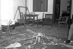
Scene of crash in garden. I think that is Pamela's overturned and scorched toy pram. Mrs Ganderton and Mrs Nepos could have sat on those chairs before the accident. (Photo credit: SPH)
Pamela (age 3), her brother Philip (age 2) and Michael Alphonso (age 5) were to become fatal casualties of the accident.
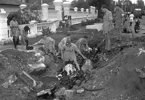
The explosion of petrol tanks and ammunition damaged a row of houses and injured their occupants. The news report describes the havoc in detail:
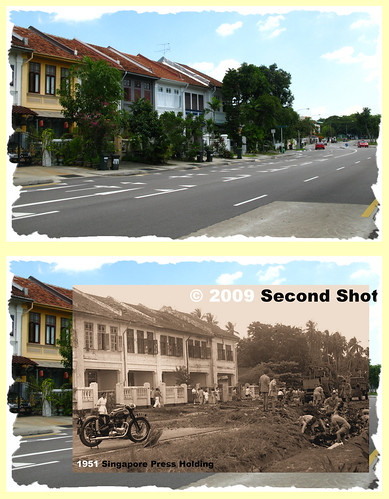
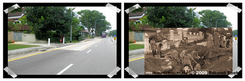
A row of seven two-storeyed houses facing the spot received the full force of the explosion. All windows were smashed and the walls splattered with earth. The roof of one house caved in and tiles were broken on the others. One engine of the plane flew over the houses to fall in a lane behind.I may not have lived in the 1950s but having lived in nearby Bedok South when young, those two-storeyed houses remain fresh in my mind. They stand out as one of a kind along that stretch of Upper East Coast Road. Since they are still standing today, I went back late last year for a second shot:
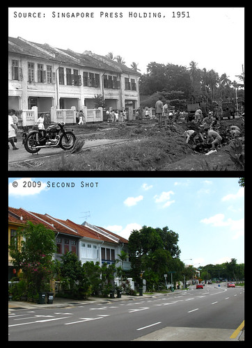
Second shot of air crash in front of the row of seven two-storeyed houses. Old roads like Upper East Coast were very much narrower in the past, i.e. single carriageway with two lanes. From the pictures, the original road now becomes the two lanes in the easterly direction. Amazingly even the old drain can be traced, if you look carefully.
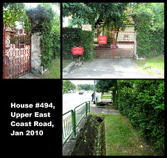
For the opposite direction, the 1951 press photo shows a long concrete fence behind the wreckage. I nearly missed this one, until Peter guided me to the correct house in the photo. The house #494, with its fence, is still standing behind a bus stop.
The white concrete fence in the 1951 photo hidden by foliage today. The fence is truncated and abruptly ends behind the bus stop. I believe #494 and its neighbour (now the Calvary Assembly of God Church) were originally built as a pair of bungalow houses. We see RAF personnel digging out an engine embedded in the road in front of what is The Calypso today.
Clockwise from left,
(1) The gate pillar, still the same after 58 years. In the old photo, you can see a group of people standing in front of it.
(2) Driveway into #494. The house behind can be seen in the old photo.
(3) The driveway today truncated as a result of "land reclamation" from the government for road widening
View from front of The Calypso. Riviera Residences in the background. "A forested slope" is pretty much my memory of the Parbury side of Upper East Coast Road. Condos like The Summit and The Baycourt came later.
One interesting observation: the government acquired land for road widening (driveway of #494 was much longer) but when lots were resold to developers, the new properties were built further away from the road. As a result the modern lots are much smaller than their antecedent. Next time if you travel along Upper East Coast Road, try to spot properties with frontage closer to the road. Those should be the original lots.

Left: #494 with The Calypso on left and Calvary Assembly of God Church on right.
Right: Hua Yu Wee Seafood with Aldea Blanca on left.
Edit on 20 June 2010: I added the original crash photo from the National Archives because the grandson of the owner of #494 has replied in the comments below.
Related post


32 comments:
Not only good second shot but excellent overlay for photo #1.
Victor (are u listening/reading???), you got competition lah!
If you check the man-holes on the road, that should give you an idea of the original road-width. Sometimes you can spot the "year" engraved on the cover. This tells you when the man-hole was dug. Check for SingTel and water sewerage man-holes. There are a couple of man-holes along Upper East Coast Road which has "Singapore Telecom" which was the old name for SingTel. BUT BEWARE OF ON-COMING TRAFFIC when you snap photos.
Peter, I must admit that I am no match for Icemoon's excellent skills. Even my equipment (camera I mean) is inferior. I got no DSLR but only point-and-shoot.
Oh, I forgot to say this. I also got no shifu to guide me lor. :p
Haha, Victor is too modest. I also have (prosumer) point and shoot. :P
Peter, when I checked those man-holes on pavement, some have dates. Never checked what's on the road. The second shot for #494 was a bit of a risk, with traffic from behind.
Icemoon. I think this one is one of your best 'projects'. I think it takes a lot of passion and discipline for details to produce this type of work. Helps that you are quite an IT wizard.
By the way. How did you get hold of the old newspaper photos?
I enjoyed your article very much -- very informative, educational and interesting.
Keep up the good work of documenting the changes in the Singapore environment. Do you have pictures of the seafront of the former St.Andrews Othopaedic Hospital (opposite Laguna Park) which will soon become another condominium?
I think you have the ingredients for an excellent book on the Katong-Bedok environment.
Thanks for the compliment. The two storey houses are unusual along that stretch of Upper East Coast. Never knew of such interesting history behind.
Chun See, the photos are from PICAS.
WK, I've seen pictures of the Bedok-Katong seafront, but not exactly one in front of the Orthopaedic Hospital.
RE: Sgt Pilots
The RAF had Sgt Pilots until, I believe, the early 60s. The 50s for sure. During WWII many pilots were sergeants and flew everything from fighters to Lancaster bombers, many giving their lives in the service of their country. Their ages ranged from 19 upwards.
Ooh, thanks for the info Peter Stubbs, never knew that.
Hmm, perhaps manpower issues and to make up for the shortfall, they rope in the NCO corps.
Corner kopi-tiam of the row of houses has a history. It was the meeting place to settle "gangland talks" between the 60s and mid-70s.
Hi Icemoon,
I'm glad I stumbled upon your post! I live at the Calypso and house 494 belongs to my friend's grandparents! My friend recounted how the seafront used to come all the way right up to the backyard of that house, and their grandparents used to set off from there on a boat! How interesting!
I was told that the property behind where the shophouses are (near Parbury and Lucky Heights) used to be a gravesite during the Japanese occupation. Do you know anything about that (whether it's true)? Perhaps that explains why there were many accounts about hauntings in the houses situated around the Lucky Heights area (hearsay only).
Cheers,
Ling
Hey LingtheMerciless, thanks for reading my blog!
Your friend must be old enough, for him/her to remember the old seafront. 494 should be declared heritage; there are not many 1950s houses left along that stretch.
There was a small cemetery, IIRC, along Lucky Heights - the road connecting Bayshore Road. I can't place it today. My relative still live beside the famous graveyard beside Blk 70 and we used to go there for our gathering but nope, we were not scared :P
Do update us if you know anything interesting about the area.
Hi Icemoon,
Not sure if the cemetary you are referring to is the mini Malay cemetary around the Lucky Heights area...if you look at the map below, the green patch next to the Lucky Gardens Playground is the Lucky Gardens Graveyard...
http://www.streetdirectory.com/asia_travel/travel/travel_id_1/travel_site_74600/
My friend (who grew up in the East and who used to stay at the Sennett area) brought to my attention that the word "Parbury" actually means graveyard
(http://www.thefreedictionary.com/graveyard)
Perhaps that's how Parbury Avenue got it's name!
Hey, I chanced upon this website (noticed from the comments that you had already gone to this website)...but I thought it was an interesting read!
"During our pursuit of the subject, we discovered a more somber past. Many are familiar with the massacre sites at Siglap, Amber Road, Upper Changi Road and Changi Creek but Bedok Hill Massacre is seldom mentioned. Why is this so? Unlike the Sook Ching victims, Bedok Hill Massacre involved captured Malay and Chinese military personnel who stood in defense of Singapore....."
http://goodmorningyesterday.blogspot.com/2009/12/world-war-two-at-upper-east-coast-road.html
Hi LingtheMerciless, the Lucky Gardens Graveyard is the one beside Blk 70, that is the one outside my relative's house. From my memory, there's another one visible if you walk along Lucky Heights down to Upper East Coast. I remember my cousin telling me long time ago there were two or three graveyards in the area.
The website you mentioned, I also helped in the research (c.f. our pursuit of the subject), haha
Cool! I've always lived in the West and only recently moved to the East and am slowly discovering my neighbourhood! I walk my doggies around this area and even to the green lung bordering the ECP at the back....and thought it would be interesting to know more about the history of this place.
Thanks for sharing!
Ling, do update us (through your blog) if you discover anything interesting. I realize you are an avid cyclist.
WOW!!!! Thanks Ling for sending me this blog! 494 is my grandparents house. The house (and the house that is now a church) was built by my granddad in 1949. Back then it was 343 and 343-1 (now 494) before the street systems changed. My mum and her siblings were living there at that time (she was 12) and that day they had gone for their classes and only the cook was home. She recalls he was so scared he hid under the table. The plane clipped and tore off the top of a tree in the house, it was a tall Areca Nut Tree (replaced by a Haru Manis mango tree since). My mum lived there until 1959 and then my paternal grandparents since then, and my granddad is still there! Over the decades I have had the occasionaly discussion about this crash, but never saw or read any articles about it until now. THanks so much for this article! My parents and all their siblings have since received it from me and are thrilled (despite it being a tragedy) to be reading about it now again... Paul
Hey Paul, thanks for reading! I'm glad your family enjoyed the dose of nostalgia :P
I added the #494 photo from NAS. Look carefully and you see a group of people in front of the gate. Could they be your mum and her siblings??!
I read the 1951 ST article again, seems like the row of shophouses opposite got all the attention. But there is a line - "It suddenly rolled and skimmed the roof of a seaside house before crashing into the road.". And you mentioned the plane clipped #494's Areca Nut Tree!
#494 is a gem along Upper East Coast. Do tell your granddad to do Singapore a favour and preserve this piece of heritage. Don't become like Butterfly House hor.
Hi Icemoon, just looked at the enlarged photo with my mum and aunt. Confirmed the people at the front of the gate - the man in white with the black specs was my mum's dad, and the girl on his left (the shorter one) is my mum, and the girls on his right (short ones) are my aunt/uncle etc.. can you let me know if the national archives has a negative i get my hands on to print this photo in higher res?
Hi Paul you can view the NAS page.
Kindly confirm again if that is your mom and relatives, haha. If you like, there's an ordering link at the top of the page. Glad to provide you a good dose of nostalgia :)
George Edmund Howson is my 92 year old grandfathers older brother...i would love more info on this incident if possible as even though we knew of how he died we had no details! and we are quite shocked!
Matt nadin (grandson of Charles howson)
email me mcnadinportraits@aol.com
George Howson was actually my fathers younger brother (Charles) who is now 92 and living in Worksop England . Thanks for the info I am sure that he will be pleased to see the photographs that you have published in your blogg. Regards Margaret Nadin (nee Howson)
Hello Margaret, I assume you are Matt' mother.
I have told Matt where his granduncle is buried. If there is anything I can help, feel free to approach me through email.
Mrs Ganderton was my late mother in law.
She had two more children both daughters.
She passed away in 1982.
Hi stu cairns, what a coincidence! Do you mean you married one of Mrs Ganderton's daughter?
Hi Paul I would love to talk to you about this further as I am the relative of the deceased Airman, And possibly will be visiting his grave this year for the first time
Hi there it is Matt the relative of George howson you spoke to previously could you please get in touch with me matt@findersbeepers.co.Uk
Concrete Driveway Augusta | This post on the 2nd Shot blog provides a historical look at a 1950s air crash that occurred in the Upper East Coast area of Singapore. The author shares archival photographs and personal reflections to document the site of the accident, offering a somber reminder of the region's aviation history and how the landscape has transformed since the mid-20th century.
The author uses archival photographs and "second shots" to document the tragedy, which killed the pilot and three children on the ground, while illustrating how the local landscape and architecture have transformed over the decades. Check out Concrete Patio Port Saint Lucie
Post a Comment