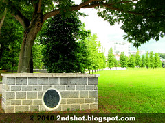
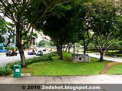
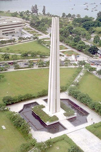
Can you see that? Imagine for a moment you are driving from Esplanade Dr. to Nicoll Highway. As the Chopstick Memorial loomed before you on your left, shift your eyes to that inconspicuous brick wall underneath the tree (hint: yellow arrow in Google Street View). What is that?
The first time I noticed it while walking along the pedestrian mall, I thought it look like some sort of commemorative wall for the War Memorial Park. By coincidence, this parapet wall sits beside the walkway leading to the War Memorial. There are four diagonal walkways leading to the Memorial and this one sits at the Esplanade Dr. entrance. There is no such wall at the Beach Road entrance where I uncovered the canal.
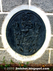
There is no other clue to its origin other than the ovalish emblem. Let us take a closer look. Oooh, I think I see Majulah Singapura.
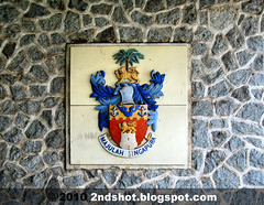
This is the second time I have seen such an emblem. My first encounter was at Mount Emily and that version was more colorful. I took a photo then so I could blog about it.
Turns out the emblem, granted in 1948, is the coat of arms for the City of Singapore. The 'City of Singapore' label was an honest mistake as Singapore did not achieve city status until 1951 (in 1948 it was a municipality). You can read more about Singapore emblems here.
A Singapore emblem (I did not know that is the coat of arms for City of Singapore) at that location is not terribly interesting, after all we know the plot of land was specially set aside by the fledgling government for the War Memorial construction. The adventure would have ended here and this blog not written (well maybe not, I could have used the photo for my infamous red dot quiz).
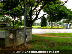
Then a few days later, I saw it again! A similar parapet wall, just metres away. How could I have missed that out the first time? Or how could I have missed out both of them all these years? I blamed the trees. Under the shade, both walls are really inconspicuous.
The other wall sits right outside the Esplanade underpass exit at War Memorial Park. It greets visitors as they descend the steps at the exit (remember exits are raised nowadays to prevent flooding at subterranean level). I do not remember using the exit before, the reason why the wall has eluded me all these years.
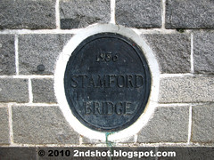
This wall is the key to unlock the mystery today - what is their purpose and why are they sitting inside the War Memorial Park? The answer lies on the emblem. Looks like we are seeing the coat of arms again .... but no.
We have found our answer! The relic is Stamford Bridge, constructed in 1956. It is a most noteworthy relic as I believe this is the only bridge remnant along Stamford Canal today. What used to span the canal - like Polglase Bridge at North Bridge Road and Malcolm Bridge at Victoria Street - are removed when the canal was covered over to become the pedestrian mall we see today.
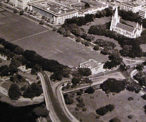
Before the Bay area and Esplanade Dr were developed, Nicoll Highway linked up with Connaught Dr at Stamford Road junction. In the 1980 photo when Stamford Canal was already covered over, you can see Nicoll Highway touching very close to the diagonal walkway leading to the War Memorial Park. Today the spot is occupied by the Esplanade underpass exit mentioned earlier. This explains why after road realignment, both walls sit further away from the road, giving the impression they are located in the park.
If you look carefully at the 1980 photo, you can see the parapet wall opposite the road under a tree. The wall would have been removed for the realignment of the road. I'd imagine four such parapet walls used to sit at the four corners of the bridge, i.e. the bridge piers. Heritage bridge markers, anyone?
A 1950s photo shows the area in its original landscape before land reclamation. No War Memorial. No pedestrian mall over Stamford Canal, i.e. the canal uncovered. You can see Nicoll Highway joining up with Connaught Dr.
The bridge remnants remind us of the days when bridges span Stamford Canal. When Stamford Bridge was constructed in 1956, it had the distinction of being the first bridge over Stamford Canal (just like Anderson Bridge was the first bridge over Singapore River until Esplanade Bridge stole the fame).




8 comments:
i walk by the place so often and i had never noticed it before too!!
Yes polestar, this is one forgotten Raffles landmark. I found only one blog posting about it and it is a Chinese blog.
This is the only bridge remnant over Stamford Canal. NHB should erect a heritage marker beside it.
is there any students visit this area?
Thanks for this very informative piece. Unfoortunately I have not been closup to those places you mention for years. Would you believe I have not even traveled along Esplanade Dr before. But this place does hold memories for us; and maybe I shall blog about it one day.
me, this is beside the pedestrian walkway used by public, including students.
Yes Chun See you should blog about town. I notice you tend to concentrate on outlying areas.
the two parapet wall is the old coastline of Singapore, so those building after the two parapet wall (toward the sea) are all reclaimed land.
Good observation from anon!
Hello, this is a nicely explained article. Your piece was very informative. Thanks for your hard work.
branding agency selangor
social media management agency malaysia
design agency kuala lumpur
Post a Comment