Pages
Mar 22, 2009
Hill 100 from 500 Feet: Air and Land Survey of Hill 100 Today
Posted by
Icemoon
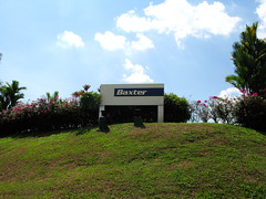
Chun See is right. Hill 100 is at the current Baxter location. :)
Because the hill was flat on top, the highest elevation would correspond to the plateau as seen in his photo from 500 feet. It was here that Chun See did his field fortification simulation exercise – Exercise Albino – in the mid 70s. The plateau is today within the Baxter compound. Therefore Woodlands Ave. 3 outside Baxter did not cut through the tip of Hill 100.
As to why the exercise was codenamed Albino, my guess is that the plateau, devoid of trees, stood out against the surrounding green from aerial observation. Indeed, aerial photos from late 60s show the plateau as one striking white patch.
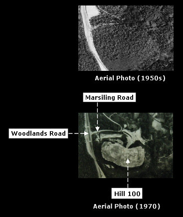
Hill 100, Different Era. The plateau stood out in the 1970 aerial. At first, I mistook the aerial for a CT scan or ultrasound.
But the white patch did not exist in an 1950 aerial. I do not know why the white patch exists thereafter. In his blog, Chun See recounted his experience of seeing cows grazing on a hill side along Woodlands Road and he believed the hill to be Hill 100. If that is true, then cows may be the culprit. Okay, I’m joking.
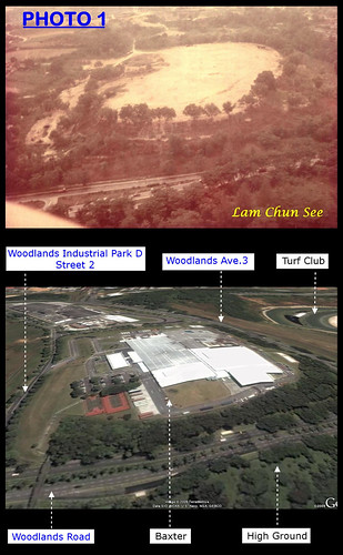
Fast forward to the present. Here is a ‘second shot’ taken at 500 feet.
Top: Old air photo (mid 1970s) from 500 feet showing Hill 100 with Woodlands Road in the foreground.
Bottom : Google Earth Terrain (circa. 2008) at 500 feet. Annotations by me.
I believe my ‘second shot’ is accurate because in the previous blog on Woodlands-Marsiling Road Junction, I have determined the U-turn along Woodlands Road to be where the overhead bridge is today. Furthermore, the high ground beside Woodlands Road are very similar in both pictures.
For many days, I poured over old aerials, photos and topographical maps, checking them against Google Earth, to ascertain how Hill 100 has changed over the years. In particular, I’m intrigued as to where Woodlands Ave. 3 cut the hill. The road was added to link Woodlands Road at Kranji with Woodlands New Town and later BKE.
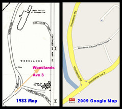
Left: Woodlands Road beside Hill 100. Map and annotation by Chun See.
Right: Google Map of the same area today. Note the addition of Woodlands Ave. 3.
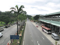
Woodlands Road at Kranji MRT Station. Ave. 3 can be seen in the background, up an incline, cutting the contours of Hill 100.
From my research, I do not think Woodlands Ave. 3 cut through the tip of Hill 100 where the plateau used to be. From the layout of Baxter and comparison with surrounding terrain, I believe the plateau was flattened for the building of Baxter (or whoever used to occupy the site).
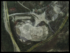
Overlay of Google Map (satellite) and aerial photo from 1970.
Today, the highest point of Hill 100 (accessible to public) is the junction of Woodlands Ave. 3 with Woodlands Industrial Park D Street 1.
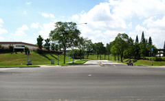
Highest point of Hill 100 today accessible to public.
It was here that I had that moment of euphoria. Walking along Woodlands Ave. 3 beside Tech Semiconductor Singapore, I noticed the slope looked suspiciously ancient. This was an area untouched by development. But not for long; the Singapore Turf Club Riding Centre is being built on the site. At the junction of Woodlands Ave. 3 with Woodlands Industrial Park D Street 1, I saw what could be the original elevation in the 1970s.
Possible original elevation opposite Baxter. In the blown up 1970s air photo, the 'white patch' plateau is in the foreground.
Articles in the series:
Part 1 – Was This Metal Box Company of Malaya?
Part 2 – Where (exactly) is Woodlands-Marsiling Road Junction?
Part 3 - Air and Land Survey of Hill 100 Today.




5 comments:
Thank you for clearing my doubts. Even up to the day when I went to check out Hill 180 with Peter, we were still debating.
Your 'second shot' at 500 ft is truly amazing. I still cannot understand how you can do that with Google earth.
More exciting research about Hill 100 to come.
Thanks Chun See for his 500ft photo. Without which the second shot would not exist.
Yes I must admit Chun See's memory is much better than mine. I "lost track" because I did not come back to this place until 2009. The last visit was 1974. So many things have changed. In particular,
I notice the Woodlands Road at the junction of Woodlands Ave 2 (location: Kranji MRT Station) and Woodlands Road has shifted more to the right to accomodate the canal. Thus the new link is more straight now whereas the old Woodlands Road was a curve.
The other change is the Woodlands and Kranji Road junction has moved to the left of the original line.
Chun See
There is a new method called OVERLAY; using the old over the new and vice versa. I wonder what kind of technique is that?
Ha? Still got more exciting research on Hill 100? Wonder what our CSI man is going to come up with next. Let me guess. Is it about the Woodlands Home of the Aged?
Post a Comment