


Collecting ang pow and stuffing yourself silly with bak kwa or pineapple tarts are traditional New Year activities for youngsters. The more "outgoing" ones may visit the Istana and Museum for free during the annual Open House. I was more "outrageous", visiting the ex-cemetery at Jalan Tanah Puteh which I blogged about here, to Victor's bewilderment. On the same day I also visited Marine Parade, to begin my search for the original coastline of East Coast, Singapore.
This mission is a response to WK who wrote in the comments:
Do you have pictures of the seafront of the former St.Andrews Othopaedic Hospital (opposite Laguna Park) which will soon become another condominium?
I do not have pictures of the seafront of the former St. Andrews Orthopaedic Hospital. Anyway the hospital has made way for an upcoming St. Andrew's Autism Centre (still under construction, TOP - 2010). What I have is an aerial photo of the seafront between the hospital and Nallur Road. Unlike the cemetery which I already knew was gone, the mission was an exercise in
For a long time, I have known the old East Coast seafront used to lie alongside Upper East Coast Road - Marine Parade Road - Amber Road. I have read narratives and seen photos of the old coastline, very nostalgic though I do not belong to that "era". How does it feel to stand at the very spot in the old photo and look at remnants or structures that used to stand majestically in the past? Few years ago, I undertook my inaugural mission to Butterfly House at 23 Amber Road. I think the mansion has been demolished or half-demolished. Also unfortunate is the fact that I have misplaced the photos taken then. So the Nallur Road seafront will be what I'm blogging today.

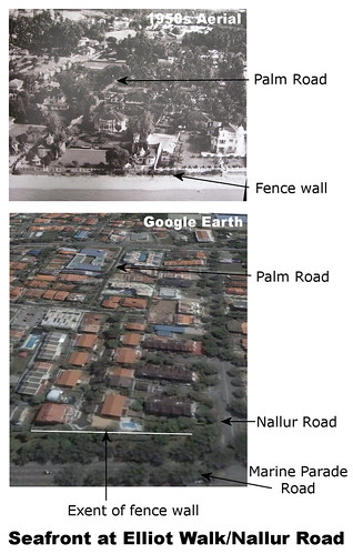
Bottom: Google Earth showing the same area today. So Marine Parade Road was the sea. Grass patch behind was the beach. The fence wall, still standing today, divides the lawn from the beach.
So I struck the jackpot. I found what appears to be the original fence wall from the old East Coast era. Now I am beginning to think whether WK was trying to lead me to the fence wall by his innocent question - "do you have pictures of the seafront .. which will soon become another condominium?" The condominium is Elliot at the East Coast which will TOP in 2013. I found the fence wall to the east, in front of Elliot Walk.
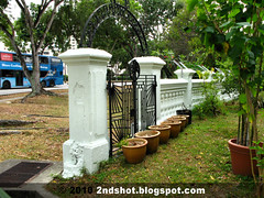
Today the fence wall is incorporated into the perimeter fence of the houses at Elliot Walk save for the portion in front of Casa Nallur. You see potted plants - a mini garden - between the fence and Casa Nallur. That small plot of land is openly accessible because the fence is truncated just before Nallur Road. A flight of stairs which I believe not to be original is built over the fence today, to connect pedestrians from Marine Parade Road to Elliot Walk.
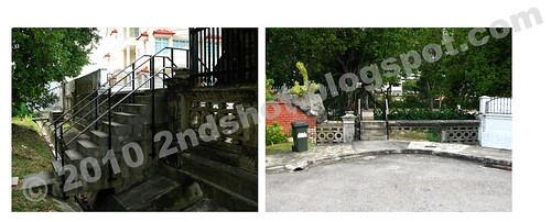
Left: The flight of stairs leading to Elliot Walk.
Right: Standing on Elliot Walk looking towards Marine Parade Road.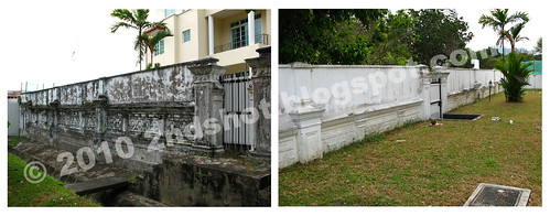
Right: A different, whitewhased view from behind, of the owner's lawn.
Is the fence wall the one in the old aerial photo? Evidence should corroborate. The fence today should look similar or near identical to the one in the aerial photo. So I examined the fence closely, counting the pillars that are found along intervals of the fence. Then I squinted my eyes to check the intervals in the aerial. What did I see?
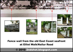
Summary of findings. Truly second shot in action, in clockwise order of thumbnails:
1.In front of the left house at Elliot Walk. Three pillars to the left will be left limit of the plot, which borders the upcoming condominium.
2. In front of the right house at Elliot Walk. Swimming pool behind.
3. In front of Casa Nallur. Three pillars to the left will be its border with the previous fence (see 1 and 2).
4. In front of Casa Nallur. Fence is truncated here. Nallur Road to the right. Thus land was taken to make way for or widen the road.
5. Same gate but different angle. Note the arch which is faintly visible in the aerial. From the gate, count the pillars .. 1 .. 2 .. 3 .. then closer interval for 4 and 5 .. 6 .. 7 .. then the previous gate. Gotcha!


16 comments:
There were several mishaps at the junction of Nallur Road and Marine Parade Road when the sea was there.
One of my friends related a story of a drowning case when they went for a swim.
The other was in 1964 when a bomb, planted by Indonesian saboteurs who landed in Singapore during Confrontation, went off and blew a hole at the old concrete fence. The photo could be found in the old Straits Times issue in 1964.
I used to take Sunday walks with my toddler in the early 80s and observe there was this huge "bell-shaped" tower of a 2-storey mansion. I think the property belonged to the Tan Lark Sye family. Now it is a row of terraced houses. The bomb explosion took place in front of the Tan residence which is now acquired by the widened Nallur Road.
Good work Icemoon! have u tried the condo at the corner of Still Road and marine Parade Road which was once a hotel? You still can see the concrete steps leading to the beach (now lokang).
Thanks for another great article.
There is also another bit of
"seaside wall" remnant at the
junction of Telok Kurau Road and
Marine Parade Road. This is a
short walk from the old hotel
site that Peter mentioned.
Incidentally, a couple of the
grand old bungalows that had a
sea-front are still around.
Let me know if you are doing more
"Second Shot" of this area. Peter,
Victor and I live in the vicinity
and I will be happy to buy lunch
for the occasion.
Regards,
Tan Wee Kiat
dr.wktan@gmail.com
---------------------------
I get excited reading this. lol. Maybe it's cos the sea was so so so near to the residential area.
Thanks icemoon for the effort. It makes our past alive...
i noticed a seawall behind the bus-stop opposite blk 57, marine parade road, it runs for a good 30 metres, before merging as part of the new drainage along that road. It was of solid stone boulder constructed unlike the normal cement mixed enbankment.
Alots could be traced of the east coast shoreline if we track from here to where the hotel site was; or we track from here to Nallur road site.
From Peter's description, looks like the concrete fence is the truncated fence I mentioned, I think I can see the bell in the aerial photo. Must check the 1964 photo, to be sure.
I remember the hotel at corner of Still Road cut into half by the construction of Still Road, lol
Dr Tan WK is very kind. Incidentally Peter and Victor had bought lunch before at different occasions. Sure, I will be doing more "second shot" of the area.
Adelin, aren't you excited because the mansions and lawns were so much bigger than today? :P
franciskum, thanks for the info. Will check out the place in future.
franciskum may be thinking of the
same sea wall I mentioned (opposite
Blk 47, and can be seen from Blk 57 Marine Terrace).
The wall is joined to the wall and
drain outside CHIJ-Katong Primary
School.
Incidentally, one afternoon while
waiting for my grand-daughter
after school I saw several small
mudskippers in this drain.
This shows that the "seaside"
connection still exists today (probably via the tidal canal next
to St Patrick's School).
Regards,
Tan Wee Kiat
Between the overhead bridge and the bus stop (in front of the Katong Convent) was a WW2 pull-box.
Between the Siglap Mosqure 9recently on fire) and the bus stop oppposite Laguna Park was also a Ww2 pill-box.
We used to run from one pill box to the other during the school holidays in late 60s. That was the time the land reclamation was completed but the ground was still very soft. If I am not mistaken there was a small pond on the reclaimed land between the 2 pill-boxes.
Some jokers in school advised us to strenthen our thigh muscles, it was best to run on the beach.
icemoon, i was with wee kiat on 25feb and i took some pictures of the same seawall. he had pointed out the wall to me on an earlier visit. after that we went for lunch - wee kiat is always buying lunch for fellow bloggers - somewhere near the siglap centre.
How I envy the retired and self-employed. They can explore seawalls and makan, blog and travel, without taking leave. Every day is like weekend.
lol, did you think that I care for the size of those landed property? I ain't no money for that! but it's really a great post.
What a great article Icemoon.A former KC girl I had a chill of melancholy reading it and the comments.Peter mentioned a hotel at the corner of Still Rd & Marine Parade Rd that apparently doesn't exist anymore.It was The Grand Hotel and I grew up in the area behind it.I gather its now another condo.Twas such a quant & sleepy area and everyone of all classes & races knew each other so we didn't need to lock our doors all the time.I've been away for many yrs and learned not too long ago that our old house in St.Patrick's Rd was torn down to build yet another condo.Apparently its not such a sleepy area anymore.I'll always be a Katong goreng as my fellow KC girls used to call ourselves.Thanks for the walk down memory lane...
the long canal running along the length of Marine Parade Rd used to be completely exposed, but sections of it were later covered up (maybe around the early to mid '90s) e.g. between Still Rd South & Parkway Parade (that's why the pedestrian footpath there is extra wide). was told that this canal marks the boundary between the former seafront & the reclaimed land that the HDB & HUDC (Lagoon View, Laguna Park & Neptune Court) flats of Marine Parade stand on. think the flats were completed after the mid-'70s & my parents moved in around 1977.
as WK mentioned, there were many grand seafront bungalows along what is now Marine Parade Rd, was told that some were owned by prominent business/plantation owner families. a few of the bungalows have been or will be incorporated into condo developments e.g. the one next to Blk 29 of The Seaview condo near the Amber Rd roundabout, the one within Grand Duchess at St Patrick's (next to St Patrick's Sec Sch), & the one near Paramount Hotel that recently made it into the news. however, the bungalow that used to stand at the northwest corner of the Telok Kurau-Marine Parade Rd junction (where the remnant of the 'seaside wall' that WK mentioned is found) has been demolished, although the plot remains empty (there were plans for a condo but the financial crisis hit).
the 2 halves of Grand Hotel still stand. for a while it served backpackers, & after it ceased operations we sometimes had ang moh backpackers wandering up & down Still Rd South hunting for the place. these days i still see people (presumably the owners?) around in the St Patrick's half of it - the other half was boarded up a few years ago. read it used to be called Karikal Mahal, & nearby there is a road (where the Shell petrol station is) named Karikal Lane.
near the junction of Marine Parade Rd & Bedok South Ave 1 end, there is a small canal running along the northern boundary of Bayshore Park condo. there used to be an old abandoned bungalow along this canal, & if memory serves me right the main entrance faced the canal & the tennis practice court between Jade & Emerald towers of Bayshore Park while the back faced Jln Hajijah...think such an orientation would make sense only if it was designed as a seafront property with the main porch & living room facing the beach? when exploring this bungalow in the late '80s & early '90s we found old user manuals for deep freezers dating from the '50s inside, & pieces of what looked like a gravestone. wonder if this canal also traces the former coastline?
That's a lot of information, straycat! Thank you very much. Will go back to the area again, for second shot and further research. :)
We started out with this very plain space and before the day was over, we had a lovely piece of art that we created. contract fencing
Post a Comment