


In his series of articles by guest bloggers on Sembawang Hills Estate, Chun See blogged on a 1966 photo from Robin Brewster that shows a young elephant strolling - purportedly - along Seraya Crescent. With no clue from Robin, many of the estate's old timers believe the elephant came from Tai Thean Kew Circus when it pitched its tent in the estate in the 1960s. However they are less sure about the exact location in the photo. Was the photo taken at Seraya Crescent? One old resident has his doubts and so far nobody can pinpoint the exact location. The lingering question remains. While I know nuts about Sembawang Hills Estate, I decide to do what I do best in this blog - explore the estate, nail down this old spot from 4 1/2 decades ago … and take a "second shot" of the same location.

Sembawang Hills Estate (source: Bing Maps)
Seraya Crescent joins Upper Thomson Road and with the neighboring roads named after trees and shrubs - Casuarina, Nemesu, Jacaranda - form phase 1 of Sembawang Hills Estate. The housings across Upper Thomson Road form phase 2. From recollections of Edward Williams and Freddy Neo, the circus tent was pitched on this side of the estate where we find the petrol station and food centre today. It is not a coincidence that Seraya Crescent is across the road and convenient enough for the mahout to bring his elephant for a stroll. In reality however, Upper Thomson today is a six-lanes dual carriageway not including the central divider island and the nearest pedestrain crossing is a distance away. Rather than risking to cross the road, wouldn't it make more sense for the mahout to exercise his animal on the same side, e.g. a circuit around Jalan Leban and Jalan Gelenggang?
An elephant roaming our street straight out of a Thai movie scene must have been a rare sight. I wonder how many living at Seraya Crescent today are in-situ residents from the 1960s; and whether they remember this cute elephant passing by their house. Many of the terrace houses there have been extensively renovated, some even torn down and rebuilt. Observe hard enough and you can still make out the original 1960s architecture from some units.
One unit struck me as odd during the exploration. #26 Seraya Crescent would not normally capture one's attention; the porch was spartan to the core, can you believe it - no potted plants, no furniture, no bicycle, only an open umbrella and some footwear. Take away the verandah supported by two thin pillars and modern aluminium grille, you are very much close to its original 1960s look, complete with circular ventilation holes above the door and windows.
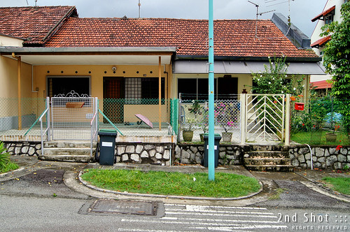
#26 Seraya Crescent on the left, an odd unit; spartan and devoid of life if not for the umbrella and footwear. #24 on the right presents a different picture.
What first aroused my suspicion was the motif on top of the gate and design of the fence. These were quite your average gate and fence in private residences in the 1960s and yet I did a double take. With Robin Brewster's photo in my hand, I asked myself, "can this be true?" I am not referring to the gate or fence that are similar in Robin's photo, but the mysterious pole-like object in the photo that suggests more than a mere coincidence at what I just saw - the two thin pillars supporting the verandah. The moment of truth arrived. I aligned myself with the gate post and pillar to match the angle shown in the photo.
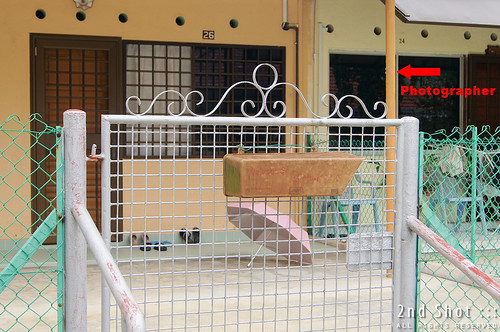
From this angle, corresponding to the gate post and pillar alignment in the photo, it looks like the photographer was standing behind the pillar when the shot was taken.
From the layout of the two terrace houses today, I suspect the photographer was standing at the edge of the tiled floor of #24 (right unit), in front of the chair and behind the fence dividing #24 and #26. In Robin's 1966 photo, we can see part of the dividing fence at the bottom and what looks like a frond leaf on the left. The leaf is probably from a potted plant beside the fence. Any gardening enthusiast like to take a shot at the plant? Oddly enough, #24 today has potted plants on all sides of the fence except at the dividing fence; the mysterious plant is also nowhere to be found though there is a tree at the corner (check the previous photo showing the two units). Lastly if Robin was a kid in 1966, the photo would have to be taken by an adult, most likely his parent.
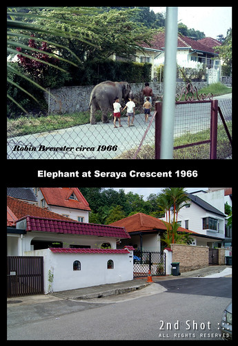
After aligning myself, I turned 180 degrees for the shot. Not exactly a precision heritage shot but since light travels in a straight line, this will do for the time being...
Finally we have the "then and now" scene at Seraya Crescent, or is it? On a cursory glance, the scene does not look anything like the 1966 photo and would have been dismissed right away if not for the pillar at #26. The saving grace is the inclination of the road and that the road is flushed with the entrance of the rightmost gate (#61) in both photos. It appears therefore that the elephant was passing by what would be the white-walled residence today (#59). As to why #59 today is not elevated from the road level, I suspect the bungalow was demolished and the land flattened, to flush the entrance with the road. Over the years, the road could also have been raised perceptibly. Another oddity is that the units on this side of Seraya Crescent are not terrace houses but semi-detached, though in 1966 they are more bungalow-like. The "stone platform" also ends abruptly behind the elephant and we can't be sure whether #57, the unit with louvered gate today, existed in 1966. Honestly, the incongruity with the 1966 photo does bother me.


18 comments:
I notice that in the 1966 photo, the gate has a horizontal bar dividing it into upper and low halves. The gate shown in photo 4 (the photo where you have the red arrow) does not have the horizontal bar.
Also, it has side rails whereas the one in the 1966 photo does not.
good observation from anonymous...
could it due to similar gates owned by the neighbours in the 60s?
anyway good effort by the author!
Good observation by Anon. What gave the game away was the gate motif and pillar. It is possible gates were similar in the 60s, but I thought it is such a coincidence you have this pair of gate and pillar at Seraya Crescent! Furthermore the inclination of the road pretty much restrict the houses to one side of a sloping road. Maybe Robin can tell us where was the photo taken, lol
Hi. Unfortunately I do not have Robin's email so I cannot refer to it. But he did refer to it as Seraya Crescent. As for whether or not this is the same place, I guess only people who have stayed there before can confirm. Perhaps I should alert my readers to come here and give their views.
Icemoon, I don’t think Upper Thomson Road was a 6-lane dual carriageway with a central divider island during the 60s. There were no pedestrian crossings as well. I notice from Google maps that there are trees on the central divider island. All these were absent during the late 50s to the 60’s. I vaguely recall that Upper Thomson Road was quite narrow, 2 lanes each way. The road was probably widened after the mid 70s. The traffic along Upper Thomason Road would have been much lighter in the 60s as the surrounding area was less populated. During this period Ang Moh Kio was not yet built; the region behind Jalan Lanjut in Phase 2 was entirely rural.
Yes, the estate has undergone dramatic changes since my departure. Up to the mid 70s there were no two-storey houses there. All the homes were either 3 bedroom terraced or semi-detached bungalows. Not all houses have a parking space within the property. Jalan Lanjut, for example, is fairly steep and most of the houses are raised above ground level. Residents have to park along the street. Today all the houses in Phase 2 have been rebuilt. Now you see 2 and 3 storey houses in every street. The entire Phase 2 has been transformed from a typical working class estate to an exclusive upper class estate. This was a big surprise to me when I took a tour of Phase 2 via Google map. I could not recognise most of the streets there. And this was my home town for 2 decades.
Over the years I’ve looked at Robin’s photo several times and became more and more convinced that the street could well be Seraya Crescent. From your investigative experience I gather that you are also convinced that it is Seraya Crescent. That makes the two of us! Nice article and good photos too.
1966 pic has a granite retaining wall, which means to say that the house was built on a higher ground than street level. The granite wall also indicates that one owner of the semi-d house has concrete steps as his "main gate" whereas his neighbour who owns the other half of the house has a main gate with a short driveway. Your modern day pic - the last one in particular has a side road whereas the owner with the driveway shares a common fence with his other neighbour to his right.
Also the elephant seemed to be walking uphill. You probably have to find the street in that area which has a slope. Sloping roads are seldom raised unless there is a history of flooding.
Chances are the house could have been demolished.
If I assume the house owner with the granite wall has demolished his wall to make it level with the street today, he would have to demolished his house/rebuilt to make it level with the street too.
If you ask the question whether his semi-d neighbour did likewise to rebuild the house. If he did then you have a pair of new semi-ds at the same level with the street. This way it will be difficult to find the former 1966 houses.
The strongest clue is the sloping road; this does not change.
I think Icemoon has got it right. As for that gate; very very unlikely that it is the same gate after nearly 40 years. I have been staying in the same house for about 25 years and I have changed my gate twice.
Icemoon, why don’t you dispel all your doubts by a face-to-face enquiry with the occupants of #59 and #57? The surrounding neighbours could also be of some assistance. This may seem somewhat intrusive, but there is the added opportunity to promote Second Shot and GMY to them! Many of the original residents would have sold out and moved onto other areas. My memory of Phase 1 (where Seraya Crescent is situated) is not good mainly because I hardly had much to do with that part of the estate (which is across Upper Thomson Road from Phase 2) during the mid 60s.
I'm the same Anon who posted the first comment. Just want to add that the mysterious pole in the 1966 photo is probably not the pillar shown in photo 4.
The pillar appears to be thicker. It would cover a larger portion of the photo if the photographer was standing behind it.
When I went back a second time before CNY, the door (not the gate) was wide open in #24 but there was a dog. I figure it is better to collect more information in the blog first, before asking the owner, "did you rent out your house in the 1960s to an ang moh family?"
As to #59 and #57, we can kind of forget it. #57 is advertised for rent and #59 (with the white wall) is occupied by this young Caucasian man, maybe expat. He would not know the house's history.
the average life span of elephant can be up to 70 years old
i'd like to believe that the elephant is still alive today :P
Hi, Icemoon,I read with interest about your reference to possibly a Tai Thean Kew (TTK) Circus pitched at a site at Sembawang Hill Estate in the sixties. However, I do remember there was a circus (not sure the name)at a vacant field (now Bishan Park) along Ang Mo Kio Ave 1 around 1984 or so. The cirucs site was somewhere opposite the present Blks 235 or 244. I knew about it because I was on official field duties around the that area then. I hope some older residents in AMK still staying there, could be able to confirm it. When our family was staying in a kampong in Tanjong Pagar (formerly S'pore Harbour Board land), there was indeed a TTK Circus right at our kampong doorstep !! That was around 1961 or 1962. We were lucky then because as kids we loved the circus with all the wild animals.
I'm a relatively new resident in seraya crescent. The picture shown indeed looks like seraya crescent. In fact u still can find the low granite retaining walls in units 47 & 49. However, what is puzzling is the clear color photos supposedly taken in 1966..?
Thanks FL for sharing. I'd like to believe, like Jumbo, the elephant is still alive too. I wonder what happened to the circus animals?
Meaningful cloud ... you staying in Seraya Crescent?! Yes, the photo taken in 1966. If possible maybe you like to chat with the occupant of #24, who may be the original occupant of the house in 1966! You can show them the photo and produce the real second shot. If you are interested, email me and we take this offline. :)
Hi, I remebered watching a performance at TTK Circus in the late 60s. I was staying at Jalan Bukit Merah then and the circus tent was pitched on an empty field opposite Blk 105 (where I stayed). The field is now filled with flats. Back then, the circus helpers were leading the elephants during feeding time plucking leaves from the trees which lined the road.
Thanks to oldies like Edward who reminisces how Sembawang Hills Estate was like during the early days. I crossed the road in my latest blog post to check out the Phase 2 houses. They still retain the favour of the original design!
@Icemoon,
Actually if you noticed, the motif above the gate seems to be the original design for all houses. Using google street view, notice that there are a couple or so houses still have this gate. But interesting, move down to unit #12, notice the house still has the orginal gate with the motif, but this time, it doesn't have the front handle bars as exactly to the '66 photo. And 1 more interesting thing, see the unit opposite the road, it is sitting on a broken granite wall! And steps running down the wall to the road! And the road is still inclining. But there seems to be a slight problem, the angle of the motif gate to the granite wall seems a bit off. So it could also be unit #10/#8, which also could mean the said motif gate is no longer existing.
Post a Comment