


Recently it was announced that 20 new parks would be opened in the next five years and at the opening of the $76 million Bishan-Ang Mo Kio Park, we were told that some of the existing parks like East Coast Park and Jurong Lake Park would be rejuvenated. It is laudable of the planning authorities that despite the built-up, of buildings and population, we are still very much a garden in a city. One park, however, seems to have been forgotten by the authorities and regrettably, part of its history - a cannon - had been erased. This is not your normal neighborhood or seaside park; it does not sit on reclaimed land like East Coast Park but on the old shoreline of Pasir Panjang.
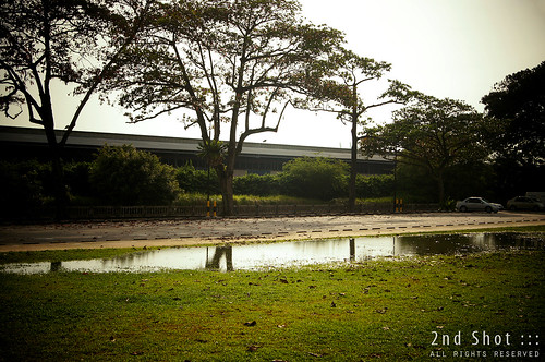
It was a sorry sight at Pasir Panjang Park on my visit during the Circle Line Open House. I have blogged about the missing 'Kulasingha cannon'. Also missing were the park benches and park signboard from the green lawn that was covered with fallen leaves, so there was no place to rest our butt. The park is not promoted as an attraction in SMRT website on the Circle Line; and on the NParks website, I could not even find it under the Park directory! With no physical park structures and no mention under NParks website, my greatest fear is that it has been de-gazetted.
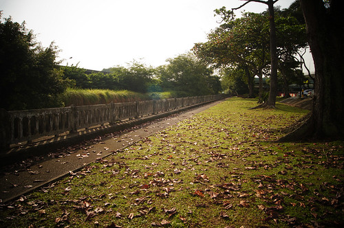
I am much intrigued by this small park with its weather-beaten concrete railings that marks out the original shoreline still standing. Where once folks could look out to the sea much like Labrador Park today, the sea-view is now blocked by Pasir Panjang Wharves on reclaimed land. A small canal separates the railings from the wharves and the murky water reminds us of what used to be the sea.
This is a largely forgotten 'heritage park' which neither NParks nor NHB have erected a marker to introduce the history. As usual, curious of a site's geographical past, I browsed through some of the old news articles but before I sat down to compiling them (as usual, procrastination), reader Pat beat me to it. Luckily she did; what she kindly shared in my previous post as comments was a first-class, concise summary of Pasir Panjang Park! A substantial write-up on the park's history, a delightful reading that I must share with the audience. She even gave the most plausible reason for the existence of 'Kulasingha cannon'!
Here I reproduce Pat's comments verbatim; photos and captions from me:
This is definitely one of those parks which both the Municipal and the people fought very hard for -- to bring it into existence, and to keep it intact.
The original 5-acre site beside the sea used to house a former mental hospital and a beri-beri hospital. Between 1928 and 1930, there was a long-drawn debate between the Municipal Council (which wanted to convert the disused site to a public seaside park) and the colonial government (which was strongly against the idea). Mr J.W. Harries of the Municipal had envisioned a green belt of public coastal parks stretching from the proposed Pasir Panjang Park all the way to Katong, so as to counter private individuals who were enclosing much of the remaining seafront.
Development works apparently began in 1931; by May 1933 (or earlier), Pasir Panjang Park had come into existence. The park became very popular as an outdoor sports venue -- it had a football-cum-golf field which was also used as a play area by European kids.

By Sep 1937, the palms and flowering shrubs in the park proved so attractive that they were "taken away" at night by nearby residents -- and transplanted into their own gardens. (To deal with these plant thefts, the S'pore Rural Board proposed to protect the park's flora with "a high enclosure of barbed wire" !)
In the run-up to WWII, the park was one of 2 sites (the other being S'pore Botanic Gardens) used as demonstration plots for growing vegetable crops and fruit trees in the government's campaign to encourage self-sufficiency in food supplies.
During the WWII occupation, the Japanese army apparently "reduced [the park] to shambles", and built 3 big timber buildings on the site for use as army camps. In the immediate post-war period, the site became out-of-bounds to the public, as the British military was using it as a army depot until Jun 1951.
After the Rural Board reacquired the site in Jun 1951, a series of disputes arose over how the place should be utilized. The Rural Board declined to convert the site back to open space, but instead leased out 2 of the buildings to the Colonial Police for use as living quarters by its married officers. Earlier in May 1951, the Rural Board suggested that a replacement park be built "on the opposite side of the road", but this was met with opposition from the public who felt that the "barren ridge" (ie. now Kent Ridge) was too steep and inaccessible.
In the same month, Mr H.J.C. Kulasingha (chairman of the Pasir Panjang Rural District Committee) proposed to use one of the big timber buildings at the park as a temporary community hall. However, the plan was abandoned in Apr 1952, because Mr Kulasingha felt that the "estimated $30,000 for repairs was 'a colossal amount' to spend on such 'an old building'".
The Colonial Police returned the site to the Rural Board in Jun 1954. Subsequently, the "dilapidated" buildings were demolished and some improvements made to the site, before it was officially re-opened as a public park by the Chief Minister on 23 Jul 1955.
In Jan 1956, the Rural Board announced a $70,000 "face lift" project that aimed to transform Pasir Panjang Park into a "rural seaside promenade". The redevelopment plan included a new playground, swimming facilities, bathing and changing rooms, park benches, flowering shrubs, as well as hawker's stalls and a carpark. (Note: The mini cannon as presented by Mr Kulasingha in Jan/Feb 1957 was most likely meant to commemorate the launch of the re-developed park.)
Over the next 25 years, Pasir Panjang Park appeared to be a "happening" destination visited by nearby residents and even tourists. The Police Band also held regular public concerts there, while the Pasir Panjang Boys' Club provided movie screenings at its club house located beside the park.
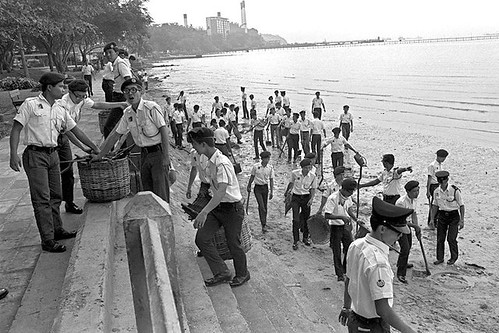 Beach cleanup at Pasir Panjang Park in 1971 (source: MITA). Pasir Panjang Power Station visible in the background.
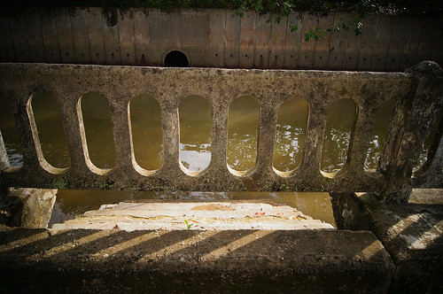 The weather-beaten concrete railing visible in the 1971 photo. I'd like to think this was the same railing and steps in the 1971 photo.
Thanks Pat for this delightful reading of the history of Pasir Panjang Park! See more photos of the park in my album here.
In Jun 1980, a member of the public (who had observed "rapid reclamation work" along the western coast of S'pore) wrote to the ST Forum with a suggestion to extend the park all the way to West Coast Road, and proposed that the new coastal belt be called "West Coast Parkway".
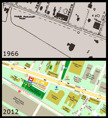
Today, looking at the tiny Pasir Panjang Park and the ghastly Pasir Panjang Container Terminal that had since invaded most of the southwestern coast of S'pore, my reaction is: Alas, alas ... what happened ??
Thanks Pat for this delightful reading of the history of Pasir Panjang Park! See more photos of the park in my album here.


12 comments:
Thanks for a most fascinating and enlightening account of the history of Pasir Panjang Park, Icemoon. I am completely oblivious to the many nuggets of history of this park.
Hmm... how come I never get such professionally written comments such as Pat's on my blog? :p
Maybe Victor should start blogging again, so we can have more of such fascinating and enlightening accounts. I miss his most readable and humorous style.
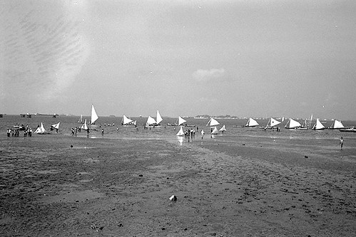
In the 1966 map,at the top left hand corner where there is right angled piece of land, there was a one story prewar house which I think was a club with Caucasian members. Tied to post around the area, were small sail boats for two and four. On certain weekends, I think depending on tide condition, they are many of them in the building.
Very interesting account, I'm left wondering what happened as well. Thanks for once again taking time to try and chart the changes. And of course the wonderful write-up by Pat.
Thanks Anon for the memory of the one storey prewar house.
Hope you guys enjoy this excellent write-up by reader Pat.
Nice post.
I remembered visiting the beach off Pasir Panjang Park 25 years ago. That time was 1991 and I was with NCC (Sea) for my sch ECA. Our training was carried out at centralised Sea Training Centres (STC). As I was then studying in Fairfield Methodist Sec Sch, I was assigned to the Pasir Panjang STC.
I remembered PPSTC was located at the junction of Hui Meng Keng Terrace and Pasir Panjang Road. The STC was a single story colonial bungalow that were built on concrete stilts. There was a rear gate which leads out .... not to the sea but to West Coast Highway! I was told by the old malay caretaker that the shoreline used to be where the rear gate was till land reclamation pushed the sea further out.
To reach the sea, we had to use the small canal which was next to the STC. From google map, you can still see the outline of the canal (located to the left of Singapore Bible Baptist Church). So you can imagine a group of sec sch students carrying canoes, 15 feet boats and the outboard motors from the STC, into the canal and then walking around 200 metres along the drain which went under West Coast Highway before we reached the sea. Most of the time, we would be praying for a high tide and that meant we could "float" the canoes/boats instead of carrying them.
Anyway, the STC has since been demolished when I was drove past the area 6 yrs ago.
Thanks Ken for the interesting account of PPSTC at the junction of Heng Mui Keng Terrace and Pasir Panjang Road! It looks like the STC colonial bungalow is the empty land in front of the junction.
Ken recalled walking along the drain that went under the West Coast Highway. Eh, cannot just jaywalk across? Anyway there is a overhead bridge there today. Someone must have seen the plight of the students and gave the authorities feedback :P
Haha!
Back then, there were no overheard bridges and we couldn't jaywalk at all as the West Coast Highway had a speed limit on 70 km/h for the vehicles travelling on it. Just imagine trying to carry 50-60 kg canoes while crossing a 3 lane road (in each direction). Not very safe!
oh boy i used to stay beside the infamous pasir panjang starlire cinema n beside my house ws the alexander brickworks. my mom use to rear chickens n ducks so when i was little i use to collect seaweed on the beach, i would start right my primary school thats batu berlayer.
i will spent time colleting lots of seaweed when its low tide all the way nwar hawpar villa. i still remember my dogs accompaying me lol. when i come back i would go around my kampung collecting stale rice, after that i would chop the seaweed n feed it to our chicken n ducks. sometime i would follow my mom to wait for the fishermen to come to shore n my mom would buy fished n crabs from them too. i miss staying i in pasir panjang i have sooo many happy childhood memories there. oh ya in food around the cinema is the best in the world!!!!
HI
Happened to come across this site while searching for Pasir Pangjan Military Cemetery. I know it was vacated in 1975 to make room for redevelopment, but does anyone know where exactly it was? My twin brother was buried there prior to being reburied in Kranji
Thanks for history
Hi Richard, the exact site is Pine Grove condominium today along Ulu Pandan Road.
Exciting development coming to Pasir Panjang with the upcoming Greater Southern Waerfront.
https://sghomeinvestment.com/
Post a Comment